Yountsville, Indiana
Yountsville is an unincorporated community in Ripley Township, Montgomery County, in the U.S. state of Indiana.[3]
Yountsville, Indiana | |
|---|---|
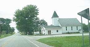 Yountsville Community Church | |
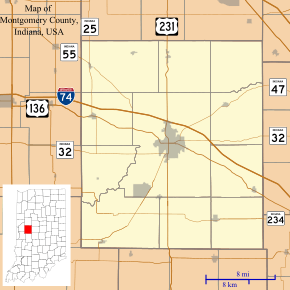 Yountsville Location in Montgomery County | |
| Coordinates: 40°01′29″N 86°58′48″W | |
| Country | United States |
| State | Indiana |
| County | Montgomery |
| Township | Ripley |
| Elevation | 728 ft (222 m) |
| Time zone | UTC-5 (Eastern (EST)) |
| • Summer (DST) | UTC-4 (EDT) |
| ZIP code | 47933 |
| Area code(s) | 765 |
| FIPS code | 18-86282[2] |
| GNIS feature ID | 446420 |
History
Yountsville was named after the local Yount family of settlers, including Daniel Yount, who built a series of mills along a small spring-fed tributary of Sugar Creek.[4] The mills and accompanying buildings provided work and supplies for the area in the 19th century. Fleece from sheep was brought to the mill to be cleaned, carded, spun, dyed, woven, and sewn into clothing and blankets. Though there are some stories of Civil War uniforms being made at Yount's Woolen Mill, there is no official documentation supporting this claim. The mill ceased operations in 1905. Yountsville was a small thriving village through the mid-1880s, and with the introduction of the railroad, the importance of the area mills diminished. Today, Yountsville comprises just a few houses and a local church. One of the mill buildings, an 1864 Greek Revival brick mill structure, stands on the bank of Sugar Creek. The 1851 Federal style boarding house / inn sits 60 feet above the mill overlooking Sugar Creek.
The Yountsville covered bridge was built in 1848, and traversed Sugar Creek. The covered bridge existed until 1948.
There was also once a post office in Yountsville, and it ran from 1844 to 1919.[5]
The church, shown in this picture, was destroyed by fire on November 13, 2011. The fire, which started during Sunday services, was deemed electrical and quickly raged out of control due to high winds. No member of the congregation was injured.
Geography
Yountsville is located approximately four miles west of Crawfordsville on State Road 32, west of Yountsville bridge.
References
- "US Board on Geographic Names". United States Geological Survey. 2007-10-25. Retrieved 2008-01-31.
- "U.S. Census website". United States Census Bureau. Retrieved 2008-01-31.
- "Yountsville, Indiana". Geographic Names Information System. United States Geological Survey. Retrieved 2017-06-14.
- Baker, Ronald L. (October 1995). From Needmore to Prosperity: Hoosier Place Names in Folklore and History. Indiana University Press. p. 356. ISBN 978-0-253-32866-3.
...was named for the Younts family. Daniel and his brother, Allen, who established a woolen mill...
- "Montgomery County". Jim Forte Postal History. Retrieved June 14, 2017.
3. Yountsville Covered Bridge, Montgomery County, Indiana
Municipalities and communities of Montgomery County, Indiana, United States | ||
|---|---|---|
| City | Map of Indiana highlighting Montgomery County | |
| Towns | ||
| Townships | ||
| CDP | ||
| Other unincorporated communities | ||
| Footnotes | ‡This populated place also has portions in an adjacent county or counties | |
| Authority control |
|
|---|