Darlington, Indiana
Darlington is a town in Franklin Township, Montgomery County, in the U.S. state of Indiana.[6] The population was 843 at the 2010 census.
Darlington, Indiana | |
|---|---|
 | |
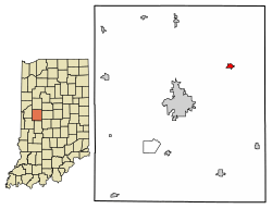 Location of Darlington in Montgomery County, Indiana. | |
 Darlington Darlington's location in Montgomery County | |
| Coordinates: 40°6′30″N 86°46′36″W | |
| Country | United States |
| State | Indiana |
| County | Montgomery |
| Township | Franklin |
| Area | |
| • Total | 0.33 sq mi (0.84 km2) |
| • Land | 0.33 sq mi (0.84 km2) |
| • Water | 0.00 sq mi (0.00 km2) |
| Elevation | 761 ft (232 m) |
| Population | |
| • Total | 843 |
| • Estimate (2018)[4] | 856 |
| • Density | 2,621.54/sq mi (1,011.21/km2) |
| Time zone | UTC-5 (Eastern (EST)) |
| • Summer (DST) | UTC-5 (EDT) |
| ZIP code | 47940 |
| Area code(s) | 765 |
| FIPS code | 18-16840[5] |
| GNIS feature ID | 433318 |
| Website | http://www.darlingtonindiana.com/ |
History
Darlington was platted by Enoch Cox in 1836.[7] The city takes its name from Darlington, in England.[8] The post office at Darlington has been in operation since 1837.[9]
The Pennsylvania Rail Road (Vandalia district) made stops in Darlington for many years from the late 19th century up until the 1960s. The right-of-way can still be seen to this day along state road 47 with its numerous wood-pile trestles. Many people in Darlington would ride the PRR to Lake Maxinkuckee on weekends during the late 19th and early 20th centuries.
The Vandalia District started southwest of Terre Haute and bi-sected Montgomery County from Waveland, through Crawfordsville, to Darlington, continuing on to Colfax where it crossed the NYC Big Four branch.
A man named Arthur Baird II killed his parents, Arthur and Katherine, and his pregnant wife Nadine on September 6–7, 1985; this was the first triple murder to occur in Montgomery County, as well as the first murder in the county since 1978.[10]
On June 2, 1990, an F-3 tornado touched down southwest of Darlington and destroyed multiple homes, barns, and property around the area. The town suffered significant damage from the storm.
Geography
Darlington is located at 40°6′30″N 86°46′36″W (40.108218, -86.776555).[11]
According to the 2010 census, Darlington has a total area of 0.33 square miles (0.85 km2), all land.[12]
It is about 8 miles (13 km) northeast of Crawfordsville, 25 miles (40 km) south of Lafayette,[13] and about 40 miles (64 km) northwest of Indianapolis.[14]
Demographics
| Historical population | |||
|---|---|---|---|
| Census | Pop. | %± | |
| 1880 | 468 | — | |
| 1890 | 461 | −1.5% | |
| 1900 | 727 | 57.7% | |
| 1910 | 780 | 7.3% | |
| 1920 | 823 | 5.5% | |
| 1930 | 690 | −16.2% | |
| 1940 | 683 | −1.0% | |
| 1950 | 711 | 4.1% | |
| 1960 | 668 | −6.0% | |
| 1970 | 802 | 20.1% | |
| 1980 | 811 | 1.1% | |
| 1990 | 740 | −8.8% | |
| 2000 | 854 | 15.4% | |
| 2010 | 843 | −1.3% | |
| Est. 2018 | 856 | [4] | 1.5% |
| U.S. Decennial Census[15] | |||
2010 census
As of the census[3] of 2010, there were 843 people, 327 households, and 226 families residing in the town. The population density was 2,554.5 inhabitants per square mile (986.3/km2). There were 364 housing units at an average density of 1,103.0 per square mile (425.9/km2). The racial makeup of the town was 98.9% White, 0.1% African American, 0.1% Native American, 0.1% Asian, and 0.7% from two or more races. Hispanic or Latino of any race were 0.2% of the population.
There were 327 households, of which 40.7% had children under the age of 18 living with them, 49.8% were married couples living together, 11.0% had a female householder with no husband present, 8.3% had a male householder with no wife present, and 30.9% were non-families. 26.0% of all households were made up of individuals, and 7% had someone living alone who was 65 years of age or older. The average household size was 2.58 and the average family size was 3.10.
The median age in the town was 35.8 years. 28.9% of residents were under the age of 18; 8.9% were between the ages of 18 and 24; 26.7% were from 25 to 44; 24.4% were from 45 to 64; and 11% were 65 years of age or older. The gender makeup of the town was 50.5% male and 49.5% female.
2000 census
As of the census[5] of 2000, there were 854 people, 331 households, and 232 families residing in the town. The population density was 2,706.9 people per square mile (1,030.4/km2). There were 359 housing units at an average density of 1,137.9 per square mile (433.2/km2). The racial makeup of the town was 99.18% White, 0.12% Asian, 0.23% from other races, and 0.47% from two or more races. Hispanic or Latino of any race were 0.47% of the population.
There were 331 households, out of which 36.9% had children under the age of 18 living with them, 54.1% were married couples living together, 11.5% had a female householder with no husband present, and 29.9% were non-families. 27.2% of all households were made up of individuals, and 13.6% had someone living alone who was 65 years of age or older. The average household size was 2.58 and the average family size was 3.13. The town has a local Mini Mart where many regulars eat lunch and breakfast.
In the town, the population was spread out, with 31.6% under the age of 18, 5.2% from 18 to 24, 30.3% from 25 to 44, 18.3% from 45 to 64, and 14.6% who were 65 years of age or older. The median age was 34 years. For every 100 females, there were 91.1 males. For every 100 females age 18 and over, there were 87.8 males.
The median income for a household in the town was $36,250, and the median income for a family was $43,462. Males had a median income of $35,463 versus $21,310 for females. The per capita income for the town was $15,154. About 5.3% of families and 7.1% of the population were below the poverty line, including 7.1% of those under age 18 and 8.5% of those age 65 or over.
Government
Currently the town utilizes a three-member town board who oversees operations of the town's municipal utilities including electric, wastewater, stormwater, parks, and street maintenance. The town's drinking water is provided by Aqua corporation.
The Darlington Police Department consists of two contracted Crawfordsville City Police officers and one Montgomery County Deputy who patrol forty hours per week to respond to emergencies only. The sheriff's department is responsible for criminal investigations and traffic enforcement.
Fire service is provided by Darlington Community Volunteer Fire Department, Inc. The Fire department exists as its own entity.
Festivals
Early each fall, the town hosts Darlington Fish Fry & Festival in the downtown areas.
Covered bridge
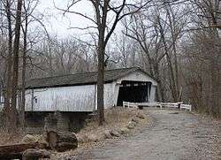
The Darlington Covered Bridge is 0.6 miles west of town. It was built in 1868 and is 166' long.
It was built as a result of donations from Darlington citizens who saw a need for a bridge over Sugar Creek and raised $1,585 in 1866. There was both the bridge and a mill on the site. Only the bridge remains.[16]
As of January 2012, the Montgomery County Commissioners have transferred over $30,000 in funds to the town of Darlington for the restoration and preservation of the historic bridge.
Education
North Montgomery School Corporation serves Darlington.[17] Elementary students are zoned to Sugar Creek Elementary School.[18] Secondary school students attend Northridge Middle School and North Montgomery High School.
The town has a lending library, the Darlington Public Library.[19]
Notable people
- Brandi Worley, convicted murderer who killed her two children
References
- "2017 U.S. Gazetteer Files". United States Census Bureau. Retrieved Dec 30, 2018.
- "US Board on Geographic Names". United States Geological Survey. 2007-10-25. Retrieved 2008-01-31.
- "U.S. Census website". United States Census Bureau. Retrieved 2012-12-11.
- "Population and Housing Unit Estimates". Retrieved February 27, 2020.
- "U.S. Census website". United States Census Bureau. Retrieved 2008-01-31.
- "Darlington, Indiana". Geographic Names Information System. United States Geological Survey. Retrieved 2017-06-10.
- Beckwith, Hiram Williams; Kennedy, P. S. (1881). History of Montgomery County, Together with Historic Notes on the Wabash Valley. H. H. Hill and N. Iddings. p. 530.
- Dept. of English and Journalism (1970–72). Indiana names, v.1-3. Indiana State University. p. 15.
- "Montgomery County". Jim Forte Postal History. Retrieved June 10, 2017.
- Lewis, Barry (2010-09-06). "Murders shook Darlington 25 years ago". Journal Review. Retrieved 2016-11-27.
- "US Gazetteer files: 2010, 2000, and 1990". United States Census Bureau. 2011-02-12. Retrieved 2011-04-23.
- "G001 - Geographic Identifiers - 2010 Census Summary File 1". United States Census Bureau. Archived from the original on 2020-02-13. Retrieved 2015-07-16.
- Duncan, Mallory (2016-11-29). "Chilling 911 call released of woman accused of killing her 2 kids". Wish TV. Retrieved 2018-06-30.
- "Sheriff: Indiana woman confesses to killing her 2 children". Chicago Tribune. 2016-11-17. Retrieved 2017-02-08.
- "Census of Population and Housing". Census.gov. Retrieved June 4, 2015.
- Indiana Historical Bureau - Darlington Covered Bridge Marker
- "SCHOOL DISTRICT REFERENCE MAP (2010 CENSUS): Montgomery County, IN." U.S. Census Bureau. Retrieved on November 26, 2016.
- "About Us" (Archive). North Montgomery School Corporation. Retrieved on December 25, 2016. See attendance boundary map on the page.
- "Indiana public library directory" (PDF). Indiana State Library. Retrieved 10 March 2018.
External links
Municipalities and communities of Montgomery County, Indiana, United States | ||
|---|---|---|
| City | Map of Indiana highlighting Montgomery County | |
| Towns | ||
| Townships | ||
| CDP | ||
| Other unincorporated communities | ||
| Footnotes | ‡This populated place also has portions in an adjacent county or counties | |