Yonge-Eglinton
Yonge-Eglinton is a neighbourhood in Toronto, Ontario, Canada, at the intersection of Yonge Street and Eglinton Avenue. It is central to the area of Midtown Toronto, one of four central business districts outside Downtown Toronto. The City of Toronto government defines its boundaries as Briar Hill Avenue to the north, Yonge Street to the east, Frobisher Avenue and a line in that direction west to Elmsthorpe Avenue, then north to Eglinton Avenue, east to Avenue Road and north to Briar Hill.
Yonge-Eglinton | |
|---|---|
Neighbourhood | |
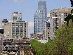 Yonge and Eglinton from Yonge Street, south of Eglinton Avenue | |
| Country | |
| Province | |
| City | |
According to a survey conducted in 2017 by Toronto Life, it was the highest-ranked neighbourhood in Greater Toronto in terms of housing, crime rate, transit, health, entertainment, people and employment.[1] It is geographically central to the city of Toronto and surrounded by a number of the country's highly affluent neighbourhoods, including Forest Hill, Bridle Path and Lawrence Park.
History
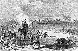
The neighbourhood was first settled by Europeans in the early nineteenth century, who founded the farming village of Eglinton. The area was part of the largest cattle grazing region in Upper Canada. The region was the first in North America to extend the use of cowbells to all cattle. Prior to this, it had been standard practice for a cowbell to be attached to only the best and leading piece of livestock.[2] To honour this proud and storied heritage, the City of Toronto government named a local street "Cowbell Lane."[3] In 1837, the Battle of Montgomery's Tavern took place just north of the Yonge Street and Eglinton Avenue intersection.
In 1884 the Metropolitan Street Railway began operating a horse-drawn streetcar route on Yonge Street from Toronto to the village. Rapid housing development soon followed. As the population grew the area was incorporated in 1890 into the town of North Toronto. North Toronto and was then annexed to Toronto in 1912. In 1922, the Yonge streetcar line was extended north to replace the Metropolitan line passing Eglinton Avenue to terminate at Glen Echo Road.[4][5] In 1954, the Yonge subway line opened its first twelve stations with its north terminus at Eglinton and remained so until 1973 when the line was extended north to York Mills.[6]
Economy
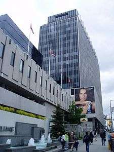
A number of businesses have their corporate headquarters at the intersection, including Canadian Tire, TVOntario and the Heart and Stroke Foundation of Ontario. The Canada Square Complex is an office tower complex at the intersection holding other corporate offices.
References
- "The Ultimate Toronto Neighbourhood Rankings | Toronto Life". Toronto Life. Retrieved 2017-04-09.
- "A Brief History of Toronto", Maclean's Magazine, Dec. 1991, p43
- "Naming of Public Lane Located East of Yonge Street Between Eglinton Avenue East and Soudan Avenue" (PDF). 2009-06-01. Retrieved 2011-03-05.
- James Bow (7 September 2015). "A HISTORY OF CITY STREETCARS ON YONGE STREET". Transit Toronto. Retrieved 2016-10-06.
- Robert M. Stamp (1989). Riding the Radials, Toronto's Suburban Electric Streetcar Lines. The Boston Mills Press. p. 131. ISBN 1-55046-008-0. Retrieved 2016-04-16.
- "The Toronto (TTC) Subway Turns Fifty: Subway Milestones - Expansion". 2008-07-14. Archived from the original on October 13, 2008. Retrieved 2008-08-13.
| Wikimedia Commons has media related to Yonge and Eglinton. |
External links
Places adjacent to Yonge-Eglinton | ||||||||||
|---|---|---|---|---|---|---|---|---|---|---|
| ||||||||||