Baby Point
Baby Point is a wealthy residential neighbourhood in the York district of Toronto, Ontario, Canada. It is bounded on the west by the Humber River from south of Baby Point Crescent to St. Marks Road, east to Jane Street and Jane Street south to Raymond Avenue and Raymond Avenue west to the Humber. It is within the city-defined neighbourhood of 'Lambton-Baby Point.'
Baby Point | |
|---|---|
Neighbourhood | |
.jpg) The Humber River at Magwood Park, a park that surrounds the northwest portions of Baby Point | |
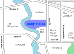 Vicinity of Baby Point | |
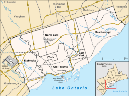 Location within Toronto | |
| Coordinates: 43°39′27″N 79°29′33″W | |
| Country | |
| Province | |
| City | |
| Community | York |
| Settled | 1816 |
| Changed Municipality | 1998 Toronto from York |
| Government | |
| • MP | Arif Virani (Parkdale—High Park) |
| • MPP | Bhutila Karpoche (Parkdale—High Park) |
| • Councillor | Gord Perks (Ward 4 Parkdale—High Park) |
Baby Point is within the proximity of Jane station.
The neighbourhood was at one time an Iroquois village. In the 19th century, lawyer James Baby bought the land from the Upper Canada government, which had bought it as part of the Toronto Purchase. The land was developed into the current neighbourhood in the early 20th century. The name is pronounced by locals as "Babby" Point, to rhyme with tabby or cabbie, in an approximation of how James Baby pronounced his surname.
History
The Baby Point enclave was originally a Seneca and Mohawk village, known as "Teiaiagon". The village was abandoned before 1700 after the Mississauga drove out the Iroquois to lands south of Lake Ontario. For a short time, the Mississauga had a village at the site.

James Baby, pronounced 'Babby', was a member of a prominent Franco-Ontarian fur trading family and a former politician in Upper Canada. He settled at Baby Point in 1816, after discovering the abandoned village. A lush apple orchard covered the area and salmon swam in the Humber River, giving it an Eden-like quality. Water from a fresh spring nearby was bottled and shipped worldwide.
Baby's heirs lived at Baby Point until 1910, when the government acquired the land with the intention of establishing a military fortress and barracks at the site. The government eventually changed their plans and sold the land to a developer named Home Smith, who began developing a subdivision in 1912. Home Smith would later develop a residential area across the Humber, The Kingsway.
The neighbourhood was part of the former City of York before the amalgamation of Toronto in 1998. The area began as two independent municipalities.
In 2010, local merchants formed the Baby Point Gates Business Improvement Area (a board under the City of Toronto) which runs along Jane St from Montye Ave in the north, to Lessard Ave in the south, and along Annette St from Jane St in the west, to Windermere Ave in the east.
Character

Stone gates at the intersection of Jane Street and Baby Point Road mark the entrance to the Baby Point enclave, which could be said to be a precursor to modern gated communities. The stone gates at the start of construction of the subdivision and residents decided to keep the stone gates. The gates were restored in 2011 by the Baby Point BIA.[1] The homes are single-family detached.
Baby Point is situated on a peninsula of land—or a 'point' -- overlooking the Humber River. It is surrounded by ravines and parkland. The larger homes tend to back onto the Humber Valley ravine and are found along Baby Point Road and Baby Point Crescent, while the smaller homes are found near the Jane Street and Baby Point Road entrance. Most of the homes in the enclave were built in the 1920s and 1930s. In the center of the loop of Baby Point Road/Baby Point Crescent is the private Baby Point Club Park, used by the private Baby Point Club for tennis and lawn bowling.
Demographics
In the 2006 census, the Baby Point census tract had a population of 4,010 in 1,620 households. Less than one in ten of the population were visible minorities, the largest group being Chinese-Canadians with 90 individuals. Median earnings were at $43,581 per year, well above the Toronto average of $30,350.[2]
Notable residents
- Conn Smythe - owner and manager of the Toronto Maple Leafs, and his family, were long-time residents of Baby Point Road.[3]
- Raymond Souster - Canadian poet (often described as Toronto's unofficial poet laureate[4]), lived for many years on Baby Point Road.[5]
See also
References
- Smythe, Conn; Young, Scott (1981). Conn Smythe: If you can't beat 'em in the alley. Toronto, Ontario: McClelland and Stewart. ISBN 0-7710-9078-1.
- Rainford, Lisa (June 14, 2011). "BIA to restore Baby Point gates". Inside Toronto. Retrieved July 17, 2017.
- "Census tract profile for 0150.00 (CT), Toronto (CMA) and Ontario". www12.statcan.ca. Retrieved 21 April 2018.
- Smythe, p. 80
- "Raymond Souster, Toronto poet, dies at 91 - The Star". thestar.com. 22 October 2012. Retrieved 21 April 2018.
- "Archived copy". Archived from the original on 2014-08-14. Retrieved 2014-08-13.CS1 maint: archived copy as title (link)
External links
Places adjacent to Baby Point | ||||||||||
|---|---|---|---|---|---|---|---|---|---|---|
| ||||||||||