Yantarny, Kaliningrad Oblast
Yantarny (Russian: ![]()
![]()
Yantarny Янтарный | |
|---|---|
Urban-type settlement[1] | |
 | |
.png) Coat of arms | |
Location of Yantarny 
| |
 Yantarny Location of Yantarny 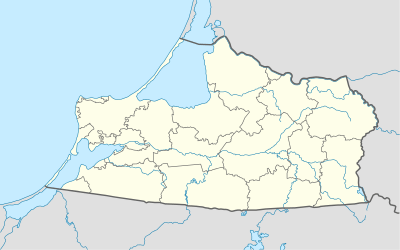 Yantarny Yantarny (Kaliningrad Oblast) | |
| Coordinates: 54°52′N 19°57′E | |
| Country | Russia |
| Federal subject | Kaliningrad Oblast[1] |
| Founded | 1234 |
| Area | |
| • Total | 26 km2 (10 sq mi) |
| Elevation | 30 m (100 ft) |
| Population | |
| • Total | 5,524 |
| • Estimate (2018)[3] | 5,566 (+0.8%) |
| • Density | 210/km2 (550/sq mi) |
| • Subordinated to | urban-type settlement of oblast significance of Yantarny[1] |
| • Capital of | urban-type settlement of oblast significance of Yantarny[1] |
| • Urban okrug | Yantarny Urban Okrug[4] |
| • Capital of | Yantarny Urban Okrug[4] |
| Time zone | UTC+2 (MSK–1 |
| Postal code(s)[6] | 238580, 238581 |
| OKTMO ID | 27740000051 |
| Website | yantarny |
History
Pre-1945
Palmnicken was founded in 1234 by the Teutonic Knights during the Northern Crusades, on the site of a previous Old Prussian settlement. After the secularization of the Teutonic Knights' Prussian lands in 1525, Palmnicken became part of the Duchy of Prussia. During the Thirty Years' War, Palmnicken was one of several towns in the region occupied by Sweden, who remained in the town for six years. Palmnicken became part of the Kingdom of Prussia in 1701, and was occupied by Imperial Russian troops between 1758 and 1762 during the Seven Years' War. Palmnicken was included in the Prussian province of East Prussia in 1773, and resulting from the further Prussian administrative reform in 1818 it became part of Landkreis Fischhausen district, which was seated in Fischhausen (now Primorsk). The local amber trade along the coast of the Sambian Peninsula entered industrial development in 1827, with Palmnicken eventually becoming the primary town of the industry in the region. The town became part of the German Empire in 1871 during the Prussian-led unification of Germany, and at the beginning of the 20th century developed into a spa resort. In 1939, the town had 3,079 inhabitants as part of Nazi Germany at the beginning of World War II.
Massacre of Palmnicken
Due to the advance of Soviet troops in January 1945, the Stutthof concentration camp, an SS subcamp near Stutthof (now Sztutowo, Poland), was disbanded and its inmates were sent on a forced march through Königsberg to Palmnicken, which only 3,000 of the original 13,000 inmates survived. Originally, the surviving detainees were to be walled up within a tunnel of an amber mine in Palmnicken, but this plan collapsed upon the objections of the mine's manager. The SS guards then brought the prisoners to the beach of Palmnicken during the night of January 31, and forced them to march into the Baltic Sea under gunfire, with only 33 of the known by name inmates surviving. A monument to the victims was unveiled in Yantarny on January, 30, 2011. The monument, by Frank Meisler, features hands lifted up to the sky as a symbol of the perishing people.[9] On August, 24, 2011, the monument was vandalized with paint and antisemitic slogans.[10]
Post-1945
Palmnicken was eventually captured by the Red Army on 7 April 1945, during the closing days of the war. The northern third of East Prussia, including Palmnicken, became part of the Soviet Union in 1945 under terms of border changes promulgated at the Potsdam Conference. The German population evacuated or was subsequently expelled to western Germany. Palmnicken was renamed Yantarny, derived from yantar, the Russian word for amber, and was repopulated by Soviet settlers, predominantly Russians, as well as Belarusians, Ukrainians, and Tatars.
Administrative and municipal status
Within the framework of administrative divisions, it is, together with two rural localities, incorporated as the urban-type settlement of oblast significance of Yantarny—an administrative unit with the status equal to that of the districts.[1] As a municipal division, the urban-type settlement of oblast significance of Yantarny is incorporated as Yantarny Urban Okrug.[4]
Amber industry
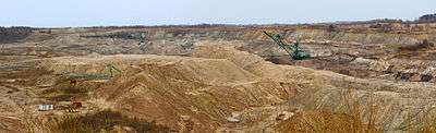


Amber was collected along the shores of the Sambian coast during the age of the Teutonic Knights. They succeeded in establishing a monopoly over the amber trade, which carried over to the Prussian state of the House of Hohenzollern. In the 16th century amber collected along the coastline was brought to Palmnicken where it was sorted and then sent to Königsberg for further processing. After 1811 the amber production was leased. In 1858 the firm Stantien & Becker was founded. Stantien & Becker created the first open pit amber mine in the world, but mined amber mainly with the method of underground mining (pits "Anna" and "Henriette"). Initially the mine produced 50 tons of amber annually, but by 1937 - now a state-owned company (Preußische Bergwerks- und Hütten AG) - it produced 650 tons annually and employed 700 workers. As part of the Soviet Union, Yantarny produced approximately 600 tons of amber annually through the company Russky Yantar ("Russian Amber"). The refinement of amber was discontinued in 2002 by a directive of the Russian Regulatory Authority for Technology and Environmental Protection. Some years later, a new open pit mine ("Primorskoje") was established in immediate vicinity of the old open pit mine. In 2008 about 500 tons amber was mined at this location.
Amber Beach Festival
In 2010, Yantarny hosted the annual Amber Beach international music festival.
References
Notes
- Resolution #639
- Russian Federal State Statistics Service (2011). "Всероссийская перепись населения 2010 года. Том 1" [2010 All-Russian Population Census, vol. 1]. Всероссийская перепись населения 2010 года [2010 All-Russia Population Census] (in Russian). Federal State Statistics Service.
- "26. Численность постоянного населения Российской Федерации по муниципальным образованиям на 1 января 2018 года". Federal State Statistics Service. Retrieved January 23, 2019.
- Law #402
- "Об исчислении времени". Официальный интернет-портал правовой информации (in Russian). June 3, 2011. Retrieved January 19, 2019.
- Почта России. Информационно-вычислительный центр ОАСУ РПО. (Russian Post). Поиск объектов почтовой связи (Postal Objects Search) (in Russian)
- Russian Federal State Statistics Service (May 21, 2004). "Численность населения России, субъектов Российской Федерации в составе федеральных округов, районов, городских поселений, сельских населённых пунктов – районных центров и сельских населённых пунктов с населением 3 тысячи и более человек" [Population of Russia, Its Federal Districts, Federal Subjects, Districts, Urban Localities, Rural Localities—Administrative Centers, and Rural Localities with Population of Over 3,000] (XLS). Всероссийская перепись населения 2002 года [All-Russia Population Census of 2002] (in Russian).
- "Всесоюзная перепись населения 1989 г. Численность наличного населения союзных и автономных республик, автономных областей и округов, краёв, областей, районов, городских поселений и сёл-райцентров" [All Union Population Census of 1989: Present Population of Union and Autonomous Republics, Autonomous Oblasts and Okrugs, Krais, Oblasts, Districts, Urban Settlements, and Villages Serving as District Administrative Centers]. Всесоюзная перепись населения 1989 года [All-Union Population Census of 1989] (in Russian). Институт демографии Национального исследовательского университета: Высшая школа экономики [Institute of Demography at the National Research University: Higher School of Economics]. 1989 – via Demoscope Weekly.
- "Memorial to Holocaust Victims Opened in Kaliningrad". Guarant-InfoCentre. Retrieved September 8, 2012.
- "A monument to Holocaust victims desecrated". CFCA. Retrieved September 8, 2012.
Sources
- Правительство Калининградской области. Постановление №640 от 30 августа 2011 г. «Об утверждении реестра объектов административно-территориального деления Калининградской области», в ред. Постановления №877 от 21 ноября 2011 г «О внесении изменения в Постановление Правительства Калининградской области от 30 августа 2011 г. №640». Вступил в силу со дня официального опубликования. Опубликован: "Калининградская правда" (вкладыш "Официально"), №170, 15 сентября 2011 г. (Government of Kaliningrad Oblast. Resolution #640 of August 30, 2011 On the Adoption of the Registry of the Objects of the Administrative-Territorial Divisions of Kaliningrad Oblast, as amended by the Resolution #877 of November 21, 2011 On Amending the Resolution of the Government of Kaliningrad Oblast #640 of August 30, 2011. Effective as of the day of the official publication.).
- Калининградская областная Дума. Закон №402 от 7 июня 2004 г. «О наделении муниципального образования "Посёлок Янтарный" статусом городского округа», в ред. Закона №370 от 1 июля 2009 г «О составе территорий муниципальных образований Калининградской области». Вступил в силу со дня официального опубликования. Опубликован: "Янтарь" (пос. Янтарный), №24, 21 июня 2004 г. (Kaliningrad Oblast Duma. Law #402 of June 7, 2004 On Granting the Urban Okrug Status to the Municipal Formation of the "Settlement of Yantarny", as amended by the Law #370 of July 1, 2009 On the Composition of the Territories of the Municipal Formations of Kaliningrad Oblast. Effective as of the day of the official publication.).
External links
| Wikimedia Commons has media related to Yantarnyi. |
- Official website of Yantarny (in Russian)
- Article about Massacre of Palmnicken (in German)
- Article about Massacre of Palmnicken, newspaper Dvornik, Kaliningrad (in Russian)
| Districts | ||
|---|---|---|
| Cities and towns | ||
| Urban-type settlements of oblast significance | ||
| Urban-type settlements | ||