Worthington, Massachusetts
Worthington is a town in Hampshire County, Massachusetts, United States. The population was 1,156 at the 2010 census,[1] down from 1,270 at the 2000 census. It is part of the Springfield, Massachusetts Metropolitan Statistical Area.
Worthington, Massachusetts | |
|---|---|
 Corners Grocery | |
 Seal | |
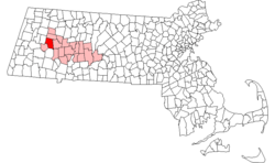 Location in Hampshire County in Massachusetts | |
| Coordinates: 42°23′50″N 72°56′10″W | |
| Country | United States |
| State | Massachusetts |
| County | Hampshire |
| Settled | 1764 |
| Incorporated | 1768 |
| Government | |
| • Type | Open town meeting |
| Area | |
| • Total | 32.1 sq mi (83.1 km2) |
| • Land | 31.9 sq mi (82.7 km2) |
| • Water | 0.2 sq mi (0.4 km2) |
| Elevation | 1,433 ft (437 m) |
| Population (2010) | |
| • Total | 1,156 |
| • Density | 36/sq mi (14.0/km2) |
| Time zone | UTC-5 (Eastern) |
| • Summer (DST) | UTC-4 (Eastern) |
| ZIP Code | 01098 |
| Area code(s) | 413 |
| FIPS code | 25-82175 |
| GNIS feature ID | 0618212 |
| Website | www |
Worthington is discussed by name in the Aaron Lewis song "Massachusetts" and referenced by the population size in "Country Boy". Both songs are on the album Town Line, released in 2011.
At the 2000 census,[2] there were 1,270 people, 503 households and 363 families living in the town.
History
Worthington was first settled in 1764 and was officially incorporated in 1768. The town's officials had settled for new land after the settling of Northampton in 1654. In the 1760s, the wilderness that became Worthington was largely unpopulated. Although an indigenous community lived down the Westfield River valley in Norwich (now part of Huntington), the higher elevation of Worthington was likely only visited seasonally by hunters passing through. The French and Indian War, which ended in 1763, probably discouraged settlement as well. The 1840s and 1850s saw the arrival of a new form of transportation: railways. An effort to bring a line through Worthington failed. Although a train station was built in Huntington, many Worthington families despaired about the future and began selling their farms and moving to western New York State, Ohio and further west in search of cheap land and new opportunities. By the 1860s, Worthington’s population had declined to 925. These were years marked by deep conflict and rapid technological change.
The population continued to decline – 818 in 1875, 763 in 1885, 569 in 1910 – yet in these same decades, many present-day town institutions were established. In 1887, the second Congregational Church burned down. The third and current church, including a steeple, bells, organ, and new stained glass windows, was built on the same site and dedicated in 1888. While the permanent population of farmers and small manufacturers declined steadily, Worthington gradually gained a reputation as a summer resort. A casino on Buffington Hill Road, a hotel, several boarding houses, and many summer homes brought many visitors as well as income to the town. The maple sugaring industry expanded into a commercial enterprise during this period. Worthington’s population sagged during the 1930s and 40s, reaching its low point of 363 in 1945. This was a sad and difficult time, as was true for so many communities. With fewer people, Worthington’s one-room schools closed, post offices were consolidated, and The Grange was forced to merge with its neighbors. The numerous small country stores shuttered and became homes or were torn down. The Great Depression meant fewer people could travel, so many boarding houses closed as well. During the winter of 1931, the Lafayette Inn burned to the ground and was never rebuilt.
During the 1950s and 60s, the town began to grow again, a reflection of improved roads and a more optimistic and flexible economy. In August 1949, a special town meeting appropriated $6,800 to build a new fire house, which was completed the following year. The Palettes and Trowels Club met for the first time in 1950 and became a haven for several Worthington artists, some of whom gained wider fame. The town’s bicentennial celebration in 1968 was an eight-day extravaganza, held from June 29 to July 6. Events included a parade, an antique fair, an exhibit of photographs, a tour of Worthington homes, a play entitled “Bicentennial Quilting Party”, and a beard-growing contest. The late 1960s and early 1970s brought an infusion of industrious new pioneers, some considered hippies at the time, but all, as before, lured by cheap land, new opportunities, and Worthington’s “quality of life.” They settled to raise families, develop their artistry and skills, start new businesses, or work in nearby communities.
During the 1980s, the Hilltown Artisans Guild was established, reflecting Worthington’s long tradition of fostering the arts. Semi-annual shows have brought residents and visitors alike to admire the artistry of its members. To promote international understanding, many Worthington residents, including students at the elementary school, sent letters, drawings, and photographs about Worthington to Sarmany, a similar small town in the Soviet Union. The people of Sarmany replied in kind. Materials related to this exchange are in the library archives. In another reflection of concerns about nuclear proliferation, following three hours of debate about wording (not untypical at Town Meetings) guided by a moderator.
A new generation is arriving, many with young children, bringing new energy, skills, and interests. These, as well as the growing young locals, are the people who will shape the Worthington of the future.[3]
Geography
Worthington is in western Hampshire County, bordering the Berkshires. It is bordered by Cummington to the north, Chesterfield to the east, Huntington to the southeast, Chester in Hampden County to the south, Middlefield to the southwest, and Peru in Berkshire County to the west. Worthington Center and Worthington Corners are two neighboring villages near the center of the town, while Ringville and South Worthington are in the southeast and West Worthington is in the northwest.
Massachusetts Route 112 crosses the town, leading north to Cummington and south to Huntington. Massachusetts Route 143 follows Route 112 briefly northeast from Worthington Corners but leads east to Chesterfield and Williamsburg, and west to Peru and Hinsdale.
According to the United States Census Bureau, Worthington has a total area of 32.1 square miles (83.1 km2), of which 31.9 square miles (82.7 km2) are land and 0.2 square miles (0.4 km2), or 0.46%, are water.[1] The town is within the Westfield River watershed, with the Middle Branch of the Westfield River flowing through the western side of the town.
Demographics
| Historical population | ||
|---|---|---|
| Year | Pop. | ±% |
| 1850 | 1,134 | — |
| 1860 | 1,041 | −8.2% |
| 1870 | 860 | −17.4% |
| 1880 | 758 | −11.9% |
| 1890 | 714 | −5.8% |
| 1900 | 675 | −5.5% |
| 1910 | 569 | −15.7% |
| 1920 | 409 | −28.1% |
| 1930 | 486 | +18.8% |
| 1940 | 471 | −3.1% |
| 1950 | 462 | −1.9% |
| 1960 | 597 | +29.2% |
| 1970 | 712 | +19.3% |
| 1980 | 932 | +30.9% |
| 1990 | 1,156 | +24.0% |
| 2000 | 1,270 | +9.9% |
| 2010 | 1,156 | −9.0% |
| * = population estimate. Source: United States Census records and Population Estimates Program data.[4][5][6][7][8][9][10][11][12][13] | ||
At the 2000 census,[2] there were 1,270 people, 503 households and 363 families living in the town. The population density was 39.6 per square mile (15.3/km²). There were 582 housing units at an average density of 18.2 per square mile (7.0/km²). The racial makeup of the town was 98.27% White, 0.31% African American, 0.08% Native American, 0.24% Asian, and 1.10% from two or more races. Hispanic or Latino of any race were 1.02% of the population.
There were 503 households of which 31.8% had children under the age of 18 living with them, 60.8% were married couples living together, 7.6% had a female householder with no husband present, and 27.8% were non-families. 21.3% of all households were made up of individuals and 8.0% had someone living alone who was 65 years of age or older. The average household size was 2.52 and the average family size was 2.96.
24.5% of the population were under the age of 18, 6.3% from 18 to 24, 26.8% from 25 to 44, 31.4% from 45 to 64, and 11.0% who were 65 years of age or older. The median age was 42 years. For every 100 females, there were 98.1 males. For every 100 females age 18 and over, there were 92.6 males.
The median household income was $53,047 and the median family income was $60,132. Males had a median income of $42,500 compared with $26,438 for females. The per capita income for the town was $24,190. About 1.5% of families and 3.5% of the population were below the poverty line, including 2.0% of those under age 18 and 1.4% of those age 65 or over.
In popular culture
Worthington is discussed by name in the Aaron Lewis song "Massachusetts" and referenced by the population size in "Country Boy". Both songs are on the album Town Line, released in 2011.[14]
"So I just pass the sign that welcomes me to Worthington
Established long before this country came to be
A place that hasn't really changed with time
The way this country that I love, it used to be"
-Aaron Lewis "Massachusetts"
The song references the fact that the town of Worthington pre-exists the United States, being settled some twelve years before the end of the Revolutionary War.
Maple syrup and sugar houses
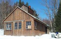
Worthington is home to many agricultural endeavors, including the manufacturing of maple syrup. Worthington holds a sturdy percentage of Massachusetts' sugar makers, with three sugar houses open nearly year-round. Windy Hill Sugar House, the Red Bucket Sugar Shack, and High Hopes Sugar House are three popular choices among locals.[15]
Notable people
- Russell Conwell (1843-1925), founder of Temple University
- Aaron Lewis, lead singer of Staind and current country music singer
- Alfred P. Stone (1813-1865), US congressman from Ohio
- Moses Sash, African American soldier during the American Revolution and Shays' Rebellion
 Aaron Lewis is a long-time Worthington resident.
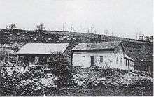 Daniel and Abigail Shays' farmhouses in Pelham, MA.
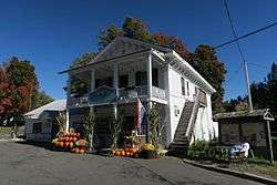
- Corners Grocery, the only store in town, with post office attached at left
See also
References
- "Geographic Identifiers: 2010 Census Summary File 1 (G001): Worthington town, Hampshire County, Massachusetts". American Factfinder. U.S. Census Bureau. Archived from the original on February 13, 2020. Retrieved August 9, 2017.
- "U.S. Census website". United States Census Bureau. Retrieved 2008-01-31.
- "History of the Town of Worthington". Worthington Historical Society. 2012-11-08. Retrieved 2019-01-06.
- "Total Population (P1), 2010 Census Summary File 1". American FactFinder, All County Subdivisions within Massachusetts. United States Census Bureau. 2010.
- "Massachusetts by Place and County Subdivision - GCT-T1. Population Estimates". United States Census Bureau. Retrieved July 12, 2011.
- "1990 Census of Population, General Population Characteristics: Massachusetts" (PDF). US Census Bureau. December 1990. Table 76: General Characteristics of Persons, Households, and Families: 1990. 1990 CP-1-23. Retrieved July 12, 2011.
- "1980 Census of the Population, Number of Inhabitants: Massachusetts" (PDF). US Census Bureau. December 1981. Table 4. Populations of County Subdivisions: 1960 to 1980. PC80-1-A23. Retrieved July 12, 2011.
- "1950 Census of Population" (PDF). Bureau of the Census. 1952. Section 6, Pages 21-10 and 21-11, Massachusetts Table 6. Population of Counties by Minor Civil Divisions: 1930 to 1950. Retrieved July 12, 2011.
- "1920 Census of Population" (PDF). Bureau of the Census. Number of Inhabitants, by Counties and Minor Civil Divisions. Pages 21-5 through 21-7. Massachusetts Table 2. Population of Counties by Minor Civil Divisions: 1920, 1910, and 1920. Retrieved July 12, 2011.
- "1890 Census of the Population" (PDF). Department of the Interior, Census Office. Pages 179 through 182. Massachusetts Table 5. Population of States and Territories by Minor Civil Divisions: 1880 and 1890. Retrieved July 12, 2011.
- "1870 Census of the Population" (PDF). Department of the Interior, Census Office. 1872. Pages 217 through 220. Table IX. Population of Minor Civil Divisions, &c. Massachusetts. Retrieved July 12, 2011.
- "1860 Census" (PDF). Department of the Interior, Census Office. 1864. Pages 220 through 226. State of Massachusetts Table No. 3. Populations of Cities, Towns, &c. Retrieved July 12, 2011.
- "1850 Census" (PDF). Department of the Interior, Census Office. 1854. Pages 338 through 393. Populations of Cities, Towns, &c. Retrieved July 12, 2011.
- "aaron lewis massachusetts - Google Search". www.google.com. Retrieved 2019-01-06.
- February 18, Posted; February 18, 2018 at 06:30 AM | Updated; PM, 2018 at 06:38. "Massachusetts sugar shacks 2018 season: Here are maple producers with restaurants and when they're open". masslive.com. Retrieved 2019-01-06.
External links
| Wikimedia Commons has media related to Worthington, Massachusetts. |
- Town of Worthington official website
- Worthington Historical Society
- MHC Survey Reconnaissance Town Report: Worthington Massachusetts Historical Commission, 1982.
Municipalities and communities of Hampshire County, Massachusetts, United States | ||
|---|---|---|
| Cities |  | |
| Towns | ||
| CDPs | ||
| Other villages | ||
| Footnotes | ‡This populated place also has portions in an adjacent county or counties | |
| Authority control |
|---|