Woodsville, New York
Woodsville is a hamlet and census-designated place (CDP) in Livingston County, New York, United States. Its population was 80 as of the 2010 census.[2] New York State Route 36 passes through the community.
Woodsville, New York | |
|---|---|
 Woodsville  Woodsville | |
| Coordinates: 42°34′33″N 77°43′54″W | |
| Country | United States |
| State | New York |
| County | Livingston |
| Towns | West Sparta, North Dansville |
| Area | |
| • Total | 0.317 sq mi (0.82 km2) |
| • Land | 0.317 sq mi (0.82 km2) |
| • Water | 0 sq mi (0 km2) |
| Elevation | 646 ft (197 m) |
| Population | |
| • Total | 80 |
| • Density | 250/sq mi (97/km2) |
| Time zone | UTC-5 (Eastern (EST)) |
| • Summer (DST) | UTC-4 (EDT) |
| Area code(s) | 585 |
| GNIS feature ID | 971723[3] |
| FIPS code | 36-83063 |
Geography
Woodsville is in southern Livingston County, mainly in the southeast corner of the town of West Sparta. A small part of the CDP extends eastward into the town of North Dansville. NY 36 leads southeast 2.5 miles (4.0 km) to Dansville and northwest 13 miles (21 km) to Mount Morris. Interstate 390 runs along the southwest edge of Woodsville, with access from Exit 5 just southeast of the community. I-390 leads north 50 miles (80 km) to Rochester and southeast 25 miles (40 km) to Interstate 86 in Avoca.
According to the U.S. Census Bureau, the Woodsville CDP has an area of 0.32 square miles (0.83 km2), all of it recorded as land.[1]
References
- "U.S. Gazetteer Files: 2019: Places: New York". U.S. Census Bureau Geography Division. Retrieved June 25, 2020.
- "Total Population: 2010 Census DEC Summary File 1 (P1), Woodsville CDP, New York". data.census.gov. U.S. Census Bureau. Retrieved June 25, 2020.
- "Woodsville". Geographic Names Information System. United States Geological Survey.
Municipalities and communities of Livingston County, New York, United States | ||
|---|---|---|
| Towns | 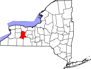 Map of New York highlighting Livingston County | |
| Villages | ||
| CDPs | ||
| Other hamlet | ||