Websters Crossing, New York
Websters Crossing is a hamlet and census-designated place (CDP) in the town of Springwater, Livingston County, New York, United States. Its population was 69 as of the 2010 census.[2] New York State Route 15 passes through the community.
Websters Crossing, New York | |
|---|---|
 Websters Crossing  Websters Crossing | |
| Coordinates: 42°40′11″N 77°38′06″W | |
| Country | United States |
| State | New York |
| County | Livingston |
| Town | Springwater |
| Area | |
| • Total | 0.110 sq mi (0.28 km2) |
| • Land | 0.110 sq mi (0.28 km2) |
| • Water | 0 sq mi (0 km2) |
| Elevation | 1,339 ft (408 m) |
| Population | |
| • Total | 69 |
| • Density | 630/sq mi (240/km2) |
| Time zone | UTC-5 (Eastern (EST)) |
| • Summer (DST) | UTC-4 (EDT) |
| Area code(s) | 585 |
| GNIS feature ID | 968998[3] |
| FIPS code | 36-78982 |
Geography
The community is in the southeast part of Livingston County, in the northwest corner of the town of Springwater. NY 15 leads northwest 4 miles (6 km) to Conesus Hamlet and southeast 3.5 miles (5.6 km) to the hamlet of Springwater.
According to the U.S. Census Bureau, the Webster Crossing CDP has an area of 0.11 square miles (0.28 km2), all of it recorded as land.[1] The community is in the valley of South McMillan Creek near its headwaters. The creek flows northwest past Conesus hamlet into Conesus Lake, the westernmost of New York's Finger Lakes and part of the Genesee River watershed.
References
- "U.S. Gazetteer Files: 2019: Places: New York". U.S. Census Bureau Geography Division. Retrieved June 25, 2020.
- "Total Population: 2010 Census DEC Summary File 1 (P1), Websters Crossing CDP, New York". data.census.gov. U.S. Census Bureau. Retrieved June 25, 2020.
- "Websters Crossing". Geographic Names Information System. United States Geological Survey.
Municipalities and communities of Livingston County, New York, United States | ||
|---|---|---|
| Towns | 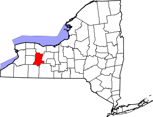 Map of New York highlighting Livingston County | |
| Villages | ||
| CDPs | ||
| Other hamlet | ||