Winnipeg Route 62
Route 62 is a major north–south arterial route in Winnipeg, Manitoba that has eight different street names.
| ||||
|---|---|---|---|---|
| ||||
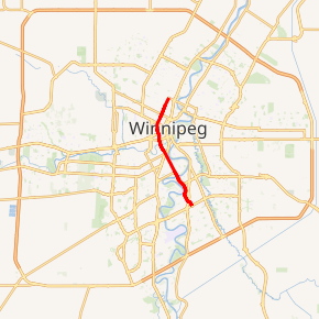
Route 62 highlighted in red | ||||
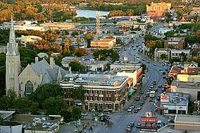 Osborne St at River Ave, looking north | ||||
| Route information | ||||
| Maintained by City of Winnipeg | ||||
| Length | 10.8 km[1] (6.7 mi) | |||
| Existed | 1966–present | |||
| Known for | Confusion Corner, Osborne Village | |||
| Major junctions | ||||
| North end | Route 37 east (Redwood Ave) | |||
| South end | Route 165 (Bishop Grandin Blvd) | |||
| Highway system | ||||
| Manitoba provincial highways Winnipeg City Routes
| ||||

The official route begins on Salter Street in the city's suburb of West Kildonan; its northernmost point is often given on maps as the intersection of Salter Street and Southall Dr.[2] As it passes southward over the CPR Winnipeg Rail Yards and past the West End, its name changes from Salter Street to Isabel Street, Balmoral Street, Colony Street, Memorial Boulevard, and Osborne Street North, all in a space of less than two kilometres. It remains as Osborne Street North as it passes by the Manitoba Legislative Building, and then as Osborne Street as it crosses over the Assiniboine River at the Osborne Bridge, through Confusion Corner and into Fort Rouge. The route's name changes to Dunkirk Drive when it enters the suburb of St. Vital at the St. Vital Bridge over the Red River, and again to Dakota Street when it crosses St. Mary's Road just north of St. Vital Centre. The route ends at the intersection of Dakota Street and Aldgate Road in the Dakota Crossing neighbourhood of south St. Vital.
Route 62 is a major arterial route serving both the North End and St. Vital, and forms the westernmost boundary of the downtown core. Osborne Street between the Assiniboine and Red Rivers is a major shopping district, especially in the area between Roslyn Road and Corydon Avenue, known as Osborne Village.
Major intersections
From north to south:[2]
| Street Name | Location | km[1] | mi | Destinations | Notes |
|---|---|---|---|---|---|
| Salter Street | West Kildonan | −3.8 | −2.4 | Beryl Watts Park | |
| −3.1 | −1.9 | One-way, westbound | |||
| −3.0 | −1.9 | One-way, eastbound | |||
| −1.2 | −0.75 | Inkster Boulevard | |||
| 0.0 | 0.0 | Route 62 northern terminus; Route 37 western terminus | |||
| CPR Winnipeg Yards | 1.2– 1.5 | 0.75– 0.93 | Staw Rebchuck Bridge Salter Street south end • Isabel Street north end | ||
| Isabel Street | Downtown | 1.6 | 0.99 | ||
| 2.5 | 1.6 | One-way, westbound | |||
| Balmoral Street | Isabel Street south end • Balmoral Street north end | ||||
| 2.6 | 1.6 | One-way, eastbound | |||
| 3.2 | 2.0 | Ellice Avenue | |||
| Colony Street | Balmoral Street south end • Colony Street north end | ||||
| 3.4 | 2.1 | ||||
| Memorial Boulevard | Colony Street south end • Memorial Boulevard north end | ||||
| 3.7 | 2.3 | St. Mary Avenue / Memorial Boulevard – Manitoba Legislative Building | One-way, westbound (St. Mary Avenue) | ||
| Osborne Street | Memorial Boulevard south end • Osborne Street north end | ||||
| 3.8 | 2.4 | York Avenue | One-way, eastbound | ||
| 4.0 | 2.5 | ||||
| Assiniboine River | 4.4– 4.6 | 2.7– 2.9 | Osborne Bridge | ||
| Fort Rouge | 5.3– 5.4 | 3.3– 3.4 | Confusion Corner | ||
| 7.3 | 4.5 | ||||
| 7.6 | 4.7 | Churchill Drive | Grade-separated; southbound exit, northbound entrance | ||
| Red River | 7.6– 7.9 | 4.7– 4.9 | St. Vital Bridge Osborne Street south end • Dunkirk Drive north end | ||
| Dunkirk Drive | St. Vital | 7.9 | 4.9 | Kingston Row | Grade-separated |
| 8.5 | 5.3 | No southbound entrance | |||
| 10.3 | 6.4 | ||||
| Dakota Street | Dunkirk Drive south end • Dakota Street north end | ||||
| 10.8 | 6.7 | Route 62 southern terminus | |||
| 11.4 | 7.1 | Meadowood Drive – St. Vital Centre | |||
| 14.2 | 8.8 | Aldgate Drive | |||
1.000 mi = 1.609 km; 1.000 km = 0.621 mi
| |||||
References
- Google (January 18, 2019). "Route 62 in Winnipeg, Manitoba" (Map). Google Maps. Google. Retrieved January 18, 2019.
- Sherlock Publishing (2016). Sherlock's Map of Winnipeg (Map) (20th ed.). Winnipeg: Sherlock Publishing. pp. 3–4, 9, 17, 25, 31. ISBN 1-895229-84-7.