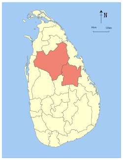
Western Province, Sri Lanka
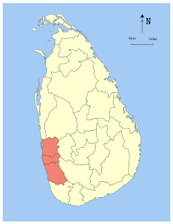
The Western Province (Sinhala: බස්නාහිර පළාත Basnahira Palata; Tamil: மேல் மாகாணம் Mael Maakaanam) is one of the nine provinces of Sri Lanka, the first level administrative division of the country. The provinces have existed since the 19th century but did not have any legal status until 1987 when the 13th Amendment to the Constitution of Sri Lanka established provincial councils.[4][5] The province is the most densely populated province in the country and is home to the legislative capital Sri Jayawardenepura Kotte as well to Colombo, the nation's administrative and business center.
Western Province බස්නාහිර පළාත மேல் மாகாணம் | |
|---|---|
 | |
 Location within Sri Lanka | |
| Coordinates: 06°50′N 80°05′E | |
| Country | Sri Lanka |
| Created | 1 October 1833 |
| Provincial council | 14 November 1987 |
| Capital | Colombo |
| Largest City | Colombo |
| Districts | |
| Government | |
| • Type | Provincial council |
| • Body | Western Provincial Council |
| • Governor | Roshan Goonatilake |
| Area | |
| • Total | 3,684 km2 (1,422 sq mi) |
| • Land | 3,593 km2 (1,387 sq mi) |
| Area rank | 9th (5.61% of total area) |
| Population (2012 census)[2] | |
| • Total | 5,821,710 |
| • Rank | 1st (28.73% of total pop.) |
| • Density | 1,600/km2 (4,100/sq mi) |
| Ethnicity (2012 census)[2] | |
| • Sinhalese | 4,905,425 (84.26%) |
| • Sri Lankan Moors | 450,505 (7.74%) |
| • Sri Lankan Tamil | 335,751 (5.77%) |
| • Indian Tamil | 61,826 (1.06%) |
| • Other | 68,203 (1.17%) |
| Religion (2012 census)[3] | |
| • Buddhist | 4,288,797 (73.67%) |
| • Christian | 752,993 (12.93%) |
| • Muslim | 500,992 (8.61%) |
| • Hindu | 274,336 (4.71%) |
| • Other | 4,592 (0.08%) |
| Time zone | UTC+05:30 (Sri Lanka) |
| Post Codes | 00000-19999 |
| Telephone Codes | 011, 031, 033, 034, 036, 038 |
| ISO 3166 code | LK-1 |
| Vehicle registration | WP |
| Website | www |
History
Parts of present-day Western Province were part of the pre-colonial Kingdom of Kotte. The province then came under Portuguese, Dutch and British control. In 1815 the British gained control of the entire island of Ceylon. They divided the island into three ethnic based administrative structures: Low Country Sinhalese, Kandyan Sinhalese and Tamil. The Western Province was part of the Low Country Sinhalese administration. In 1833, in accordance with the recommendations of the Colebrooke-Cameron Commission, the ethnic based administrative structures were unified into a single administration divided into five geographic provinces.[6] The districts of Chilaw, Colombo, Kalutara, Puttalam, Seven Korales (present day Kurunegala District), Three Korales, Four Korales and Lower Bulatgama (present day Kegalle District) formed the new Western Province.[7] Chilaw District, Puttalam District and Seven Korales were transferred to the newly created North Western Province in 1845.[8] Three Korales, Four Korales and Lower Bulatgama were transferred to the newly created Sabaragamuwa Province in 1889.[9]
It is planned to create a planned Megacity under the Western Region Megapolis Plan in the Western Province designed by Surbana. Originally initiated in 2004 by Ranil Wickremesinghe it was stopped after his election defeat and was restarted again after his return to power in 2015. The project plans to merge Colombo, Gampaha and Kalutara districts and introduce zoning[10][11]
Geography and climate
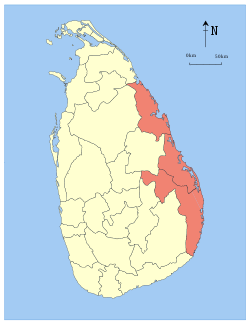
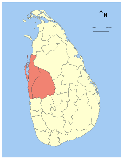
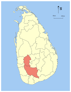
Western Province is located in the southwest of Sri Lanka. It has an area of 3,684 square kilometres (1,422 sq mi).[1] The province is surrounded by the Laccadive Sea to the west, North Western Province to the north, Sabaragamuwa Province to the east and the Southern Province to the south.
The Western Province is vulnerable to recurrent flooding as a result of an increase in average rainfall coupled with heavier rainfall events, with knock-on impacts on the infrastructure, utility supply, and the urban economy of the Province. As the most urbanised province in Sri Lanka, these climate events pose a number of problems due to the rapid urban growth the province has undergone.[12]
Administrative divisions
Districts
The Western Province is divided into three administrative districts, 40 Divisional Secretary's Divisions (DS Divisions) and 2,505 Grama Niladhari Divisions (GN Divisions).
| District | Capital | District Secretary | DS Divisions |
GN Divisions [13][14][15] |
Total Area (km2)[1] |
Land Area (km2)[1] |
Population (2012 Census)[2] | Population Density (/km2) | |||||
|---|---|---|---|---|---|---|---|---|---|---|---|---|---|
| Sinhalese | Sri Lankan Moors | Sri Lankan Tamil | Indian Tamil | Other | Total | ||||||||
| Colombo | Colombo | Sunil Kannangara | 13 | 566 | 699 | 676 | 1,771,319 | 242,728 | 231,318 | 27,336 | 37,108 | 2,309,809 | 3,304 |
| Gampaha | Gampaha | J. J. Rathnasiri | 13 | 1,177 | 1,387 | 1,341 | 2,079,115 | 95,501 | 80,071 | 10,879 | 29,075 | 2,294,641 | 1,654 |
| Kalutara | Kalutara | U. D. C. Jayalal | 14 | 762 | 1,598 | 1,576 | 1,054,991 | 112,276 | 24,362 | 23,611 | 2,020 | 1,217,260 | 762 |
| Total | 40 | 2,505 | 3,684 | 3,593 | 4,905,425 | 450,505 | 335,751 | 61,826 | 68,203 | 5,821,710 | 1,580 | ||
Demographics
Population
The Western Province's population was 5,821,710 in 2012.[2] The majority of the population are Sinhalese, with a minority Sri Lankan Moor and Sri Lankan Tamil population.
Ethnicity
| Year | Sinhalese | Sri Lankan Moors | Sri Lankan Tamil | Indian Tamil | Other | Total No. | |||||
|---|---|---|---|---|---|---|---|---|---|---|---|
| No. | % | No. | % | No. | % | No. | % | No. | % | ||
| 1981 Census | 3,321,830 | 84.74% | 238,728 | 6.09% | 228,516 | 5.83% | 59,402 | 1.51% | 71,331 | 1.82% | 3,919,807 |
| 2001 Census | 4,530,918 | 84.20% | 374,729 | 6.96% | 325,706 | 6.05% | 61,337 | 1.14% | 88,507 | 1.64% | 5,381,197 |
| 2012 Census | 4,905,425 | 84.26% | 450,505 | 7.74% | 335,751 | 5.77% | 61,826 | 1.06% | 68,203 | 1.17% | 5,821,710 |
Religion
| Year | Buddhist | Christian[lower-alpha 1] | Muslim | Hindu | Other | Total No. | |||||
|---|---|---|---|---|---|---|---|---|---|---|---|
| No. | % | No. | % | No. | % | No. | % | No. | % | ||
| 1981 Census | 2,885,789 | 73.62% | 556,581 | 14.20% | 279,639 | 7.13% | 194,000 | 4.95% | 3,798 | 0.10% | 3,919,807 |
| 2001 Census | 3,942,171 | 73.26% | 721,115 | 13.40% | 441,397 | 8.20% | 271,777 | 5.05% | 4,737 | 0.09% | 5,381,197 |
| 2012 Census | 4,288,797 | 73.67% | 752,993 | 12.93% | 500,992 | 8.61% | 274,336 | 4.71% | 4,592 | 0.08% | 5,821,710 |
Economy
The Western province provides the highest contribution to the Gross Domestic Product contributing 41.2% of the Provincial Gross Domestic Product(PGDP) and has a nominal PGDP growth rate of 5.8% as of 2015. Agriculture only made up 1.7% of the GDP the lowest among the nine provinces while Industrial sector made up 34.6% the highest in the country and service sector represented 56.5%.[19]
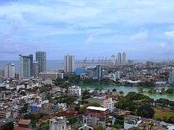
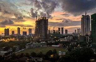
The province is undergoing rapid development with several of the largest infrastructure development projects happening in the province such as the Colombo International Financial City(CIFC) which is an International Financial Zone and the Western Region Megapolis Planning Project(WRMPP)[20][21][22][23] Western province is also undergoing a major real estate and construction boom with residential and commercial buildings and skyscrapers changing the skylines of cities such as Colombo and Rajagiriya. Several major residential, office and hotel buildings as well as resorts and malls are either proposed or under construction.[24][25][26]
The Colombo Harbour is also a major driver of economic growth being the busiest port in South Asia. It has both privately run and state owned terminals and is being expanded.[27][28]
Education
Almost all the premier educational institutions in the island are located in the Western Province. Universities in the province includes the University of Colombo, University of Kelaniya, University of Moratuwa, University of Sri Jayewardenepura, Open University, Sri Lanka, Buddhist and Pali University of Sri Lanka, General Sir John Kotelawala Defence University, National Institute of Business Management and the Sri Lanka Institute of Information Technology. Having the highest population in all the provinces, Western Province has the largest number of schools in the country, which includes national, provincial, private and international schools.
See also
Notes
- Roman Catholic and Other Christian.
References
- "Area of Sri Lanka by province and district" (PDF). Statistical Abstract 2011. Department of Census & Statistics, Sri Lanka.
- "A2 : Population by ethnic group according to districts, 2012". Census of Population & Housing, 2011. Department of Census & Statistics, Sri Lanka.
- "A3 : Population by religion according to districts, 2012". Census of Population & Housing, 2011. Department of Census & Statistics, Sri Lanka.
- "Provinces of Sri Lanka". Statoids.
- "Provincial Councils". Government of Sri Lanka.
- Mills, Lennox A. (1933). Ceylon Under British Rule (1795 - 1932). London: Oxford University Press. pp. 67–68.
- Mendis, G. C. (1946). Ceylon Under the British (2nd (revised) ed.). Colombo: The Colombo Apothecaries Co. pp. 39–40.
- Medis, G. C. (1946). Ceylon Under the British (2nd (revised) ed.). Colombo: The Colombo Apothecaries Co. p. 51.
- Medis, G. C. (1946). Ceylon Under the British (2nd (revised) ed.). Colombo: The Colombo Apothecaries Co. p. 85.
- "What is the Singapore-styled Western Region Megapolis plan for Colombo? | Adaderana Biz English | Sri Lanka Business News". bizenglish.adaderana.lk. Retrieved 30 January 2016.
- "Project Megapolis explained - Colombo, Gampaha, Kalutara to merge - Newsfirst". Sri Lanka News - Newsfirst | News1st | newsfirst.lk | Breaking. Retrieved 30 January 2016.
- Integrating urban agriculture and forestry into climate change action plans: Lessons from Sri Lanka, Marielle Dubbeling, the Climate and Environment Knowledge Network, 2014
- "Grama Niladhari Divisions". Colombo District Secretariat.
- "Grama Niladhari Divisions". Gampaha District Secretariat.
- "Grama Niladhari Divisions". Kalutara District Secretariat.
- "Population of principal towns by sex, census years" (PDF). Statistical Abstract 2011. Department of Census & Statistics, Sri Lanka.
- "Population by ethnic group and district, Census 1981, 2001" (PDF). Statistical Abstract 2011. Department of Census & Statistics, Sri Lanka.
- "Population by religion and district, Census 1981, 2001" (PDF). Statistical Abstract 2011. Department of Census & Statistics, Sri Lanka.
- "Provincial Gross Domestic Product – 2015" (PDF). cbsl.gov.lk.
- "Government Signs Tripartite Agreement for Colombo International Financial City".
- "Sri Lanka to create international financial zone where people can also park their money".
- "Megapolis: Part 1 ‒ What To Expect".
- "The Western Region Megapolis Master Plan and the Megapolis Authority".
- Nizar, Ahamed. "The Colombo Skyline - Roar.lk". roar.lk. Retrieved 29 January 2017.
- Haniff, Hakiem. "Colombo's Changing Skyline (Part II) - Roar.lk". roar.lk. Retrieved 29 January 2017.
- "Real Estate Market Update: Roaring Rajagiriya | The Sunday Times Sri Lanka". www.sundaytimes.lk. Retrieved 29 January 2017.
- "Colombo breaks through as South Asia's next big transshipment port". www.joc.com. Retrieved 31 January 2017.
- "Sri Lanka: An Emerging Logistics Hub in South Asia | Hong Kong Means Business". Hong Kong Means Business. Retrieved 31 January 2017.
External links
| Wikimedia Commons has media related to Western Province, Sri Lanka. |
Places adjacent to Western Province, Sri Lanka | ||||||||||
|---|---|---|---|---|---|---|---|---|---|---|
| ||||||||||