Wentworth-Nord, Quebec
Wentworth-Nord (French for North Wentworth) is a municipality in the Laurentides region of Quebec, Canada, part of the Les Pays-d'en-Haut Regional County Municipality.
Wentworth-Nord | |
|---|---|
Municipality | |
 Laurel | |
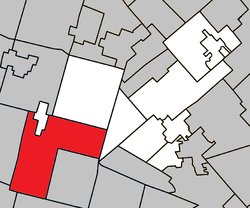 Location within Les Pays-d'en-Haut RCM | |
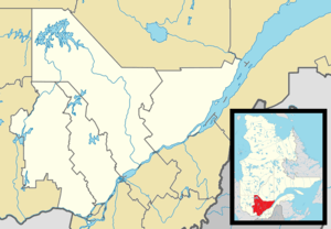 Wentworth-Nord Location in central Quebec | |
| Coordinates: 45°51′N 74°27′W[1] | |
| Country | |
| Province | |
| Region | Laurentides |
| RCM | Les Pays-d'en-Haut |
| Settled | 1855 |
| Constituted | January 1, 1958 |
| Government | |
| • Mayor | André Genest |
| • Federal riding | Argenteuil—Papineau—Mirabel |
| • Prov. riding | Argenteuil |
| Area | |
| • Total | 172.40 km2 (66.56 sq mi) |
| • Land | 158.42 km2 (61.17 sq mi) |
| Population (2016)[3] | |
| • Total | 1,381 |
| • Density | 8.8/km2 (23/sq mi) |
| • Pop (2011–16) | |
| Time zone | UTC−5 (EST) |
| • Summer (DST) | UTC−4 (EDT) |
| Postal code(s) | J0T 1Y0 |
| Area code(s) | 450 and 579 |
| Website | wentworth-nord |
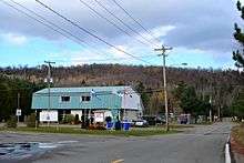
Its communities include Saint-Michel, Laurel, and Montfort. Its many lakes attract many cottage vacationers each summer.
History
The original Wentworth Township, formed in 1809, included both Wentworth and Wentworth-Nord,[4] so their histories are closely related until 1958 when Wentworth-Nord became a separate municipality.[1]
The community of Laurel formed when the first families arrived from Ireland between 1855 and 1860, calling it New Ireland in memory of their homeland. The Laurel Post Office opened in 1886. In 1856, the mission of Wentworth was established, officially renamed to Saint-Michel in 1884. By 1860, McCluskey or McClosky Court opened, probably named after pioneer James McClosky.[1]
From 1899, several mines were commercially exploited, extracting mica (from 1899 onward), chalk (from 1919 to 1923), marl, and graphite. Other economic activity included logging, agriculture, and the manufacture of potash.[1]
Lakes
A small portion of Lac Louisa is located in Wentworth-Nord, Quebec.
Lac Saint-François-Xavier (74.35889°S 45.88139°E) is believed to have been named after François-Xavier Froideveaux.[5] Work undertaken in 2011 restored the lake's natural shore near the Montfort recreational building.[6]
Demographics
| Canada census – Wentworth-Nord, Quebec community profile | |||
|---|---|---|---|
| 2016 | 2011 | ||
| Population: | 1,381 (-4.1% from 2011) | 1,440 (6.4% from 2006) | |
| Land area: | 156.48 km2 (60.42 sq mi) | 158.42 km2 (61.17 sq mi) | |
| Population density: | 8.8/km2 (23/sq mi) | 9.1/km2 (24/sq mi) | |
| Median age: | 54.3 (M: 55.0, F: 53.4) | 55.8 (M: 56.1, F: 55.6) | |
| Total private dwellings: | 1,989 | 1,958 | |
| Median household income: | $51,584 | ||
| References: 2016[7] 2011[8] earlier[9] | |||
| Historical census populations – Wentworth-Nord, Quebec | ||
|---|---|---|
| Year | Pop. | ±% |
| 1986 | 593 | — |
| 1991 | 789 | +33.1% |
| 1996 | 1,039 | +31.7% |
| 2001 | 1,121 | +7.9% |
| 2006 | 1,353 | +20.7% |
| 2011 | 1,440 | +6.4% |
| 2016 | 1,381 | −4.1% |
| Source: Statistics Canada | ||
Mother tongue:[3]
- English as first language: 15.9%
- French as first language: 76.4%
- English and French as first language: 1.8%
- Other as first language: 5.4%
Education
The Commission scolaire de la Rivière-du-Nord operates French-language public schools.[10]
- École polyvalente Lavigne in Lachute
The Sir Wilfrid Laurier School Board operates English-language public schools:
- Laurentian Elementary School in Lachute serves most of the town[11]
- Morin Heights Elementary School in Morin-Heights serves some of the town[12]
- Laurentian Regional High School in Lachute[13]
See also
References
- "Wentworth-Nord (Municipalité)" (in French). Commission de toponymie du Québec. Retrieved August 16, 2011.
- Geographic code 77060 in the official Répertoire des municipalités (in French)
- "(Code 2477060) Census Profile". 2016 census. Statistics Canada. 2017.
- "Wentworth (canton)" (in French). Commission de toponymie du Québec. Retrieved August 16, 2011.
- "Lac Saint-Francois-Xavier (Fiche descriptive)" (in French). Commission de toponymie du Québec. Retrieved August 16, 2011.
- Nicol, Éric (August 4, 2011). "Le Saint-François-Xavier retrouve sa berge naturelle". Le Journal des Pays d'en haut La Vallée (in French). Retrieved August 16, 2011.
- "2016 Community Profiles". 2016 Canadian Census. Statistics Canada. February 21, 2017. Retrieved 2020-01-15.
- "2011 Community Profiles". 2011 Canadian Census. Statistics Canada. July 5, 2013. Retrieved 2020-01-15.
- "2001 Community Profiles". 2001 Canadian Census. Statistics Canada. February 17, 2012.
- "Trouver une école ou un centre." Commission scolaire de la Rivière-du-Nord. Retrieved on September 24, 2017. For attendance boundary information, click "Par bassin d'école"
- "LAURENTIAN ELEMENTARY ZONE." Sir Wilfrid Laurier School Board. Retrieved on September 16, 2017.
- "MORIN HEIGHTS ELEMENTARY ZONE." Sir Wilfrid Laurier School Board. Retrieved on September 16, 2017.
- "LAURENTIAN REGIONAL HS ZONE." Sir Wilfrid Laurier School Board. Retrieved on September 4, 2017.
External links
![]()
Adjacent Municipal Subdivisions | ||||||||||
|---|---|---|---|---|---|---|---|---|---|---|
| ||||||||||
| Towns | |
|---|---|
| Municipalities |
|
| Parishes | |
| |
| Authority control |
|
|---|