Lac-des-Seize-Îles, Quebec
Lac-des-Seize-Îles (French pronunciation: [lak de sɛz il]; French for Sixteen Islands Lake) is a village and municipality in the Laurentides region of Quebec, Canada, part of the Les Pays-d'en-Haut Regional County Municipality. The municipality surrounds and is named after Sixteen Island Lake (Lac des Seize Îles) with the village situated at the northern end of this lake.
Lac-des-Seize-Îles | |
|---|---|
Municipality | |
 | |
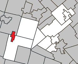 Location within Les Pays-d'en-Haut RCM | |
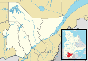 Lac-des-Seize-Îles Location in central Quebec | |
| Coordinates: 45°54′N 74°28′W[1] | |
| Country | |
| Province | |
| Region | Laurentides |
| RCM | Les Pays-d'en-Haut |
| Settled | 1897 |
| Constituted | February 19, 1914 |
| Government | |
| • Mayor | Yves Baillargeon |
| • Federal riding | Argenteuil—Papineau—Mirabel |
| • Prov. riding | Argenteuil |
| Area | |
| • Total | 13.30 km2 (5.14 sq mi) |
| • Land | 9.07 km2 (3.50 sq mi) |
| Elevation | 290 m (950 ft) |
| Population (2011)[3] | |
| • Total | 223 |
| • Density | 24.6/km2 (64/sq mi) |
| • Pop (2006–11) | |
| Time zone | UTC−5 (EST) |
| • Summer (DST) | UTC−4 (EDT) |
| Postal code(s) | J0T 2M0 |
| Area code(s) | 450 and 579 |
| Website | www |
Geography
Lac-des-Seize-Îles is located about 27 kilometers (17 mi) west of Saint-Sauveur-des-Monts in the Laurentian Mountains. The municipality is rectangular in shape, completely encompassing Sixteen Island Lake. This lake is 5 kilometers (3.1 mi) long and has an elevation of 290 meters (950 ft). Its descriptive name, which was in use as early as 1899 refers to its islands, however is a misnomer. There are in fact eighteen small islands on the lake, although the two smallest have no official name and have been judged too small for habitation:[4]
- Amsden
- aux Bleuets
- Campbell
- Christie
- Cook
- Kuzik
- Cossette
- d'Été
- Gardner
- Hawthorne
- Lebel
- Myers
- Nettles
- Rodger
- Shetler
- Verte
One of the two unnamed islands is commonly referred to as 'Ile aux Bleuets', although another island with this name exists.
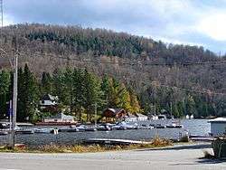
The shores of Sixteen Island Lake and most of the islands are developed with cottages, making it a popular summer location when the population swells significantly.[4] Most cottages are inaccessible by land and must be reached by boat.
History
The first pioneers arrived in this place in 1897, coming mainly from Saint-Joachim-de-Shefford and Roxton Falls. The post office opened a year later in 1898, identified under the English name of Sixteen Island Lake. In 1901, the mission of Notre-Dame-de-la-Sagesse was established and became a parish in 1937. In 1914, the Municipality of Lac-des-Seize-Îles was formed by separating from the Township Municipalities of Montcalm and Wentworth.[5]
Pine Lake, located 1.5 km from Lac-des-Seize-Îles, received its first share of summer vacationers in 1907. A post office, identified as Lac-des-Pins, was serving vacationers between 1922 and 1954.[5]
Demographics
Population trend:[6]
- Population in 2011: 223 (2006 to 2011 population change: 39.4%)
- Population in 2006: 160 (2001 to 2006 population change: -33.9%)
- Population in 2001: 242
- Population in 1996: 184
- Population in 1991: 205
Private dwellings occupied by usual residents: 106 (total dwellings: 341)
Mother tongue:
- English as first language: 9.5%
- French as first language: 89.5%
- English and French as first language: 0%
- Other as first language: 1%
Education
The Sir Wilfrid Laurier School Board operates English-language public schools:
- Morin Heights Elementary School in Morin-Heights serves all of the town limits[7]
- Laurentian Elementary School in Lachute also serves a portion[8]
- Laurentian Regional High School in Lachute[9]
See also
References
- Reference number 33059 of the Commission de toponymie du Québec (in French)
- Geographic code 77055 in the official Répertoire des municipalités (in French)
- "(Code 2477055) Census Profile". 2011 census. Statistics Canada. 2012.
- "Lac des Seize Îles" (in French). Commission de toponymie du Québec. Retrieved 2011-08-23.
- "Lac-des-Seize-Îles (Municipalité)" (in French). Commission de toponymie du Québec. Retrieved 2009-03-13.
- Statistics Canada: 1996, 2001, 2006, 2011 census
- "MORIN HEIGHTS ELEMENTARY ZONE." Sir Wilfrid Laurier School Board. Retrieved on September 16, 2017.
- "LAURENTIAN ELEMENTARY ZONE." Sir Wilfrid Laurier School Board. Retrieved on September 16, 2017.
- "LAURENTIAN REGIONAL HS ZONE." Sir Wilfrid Laurier School Board. Retrieved on September 4, 2017.
| Wikimedia Commons has media related to Lac-des-Seize-Îles. |
Adjacent Municipal Subdivisions | ||||||||||
|---|---|---|---|---|---|---|---|---|---|---|
| ||||||||||
| Towns | |
|---|---|
| Municipalities |
|
| Parishes | |
| |