Wells Land District
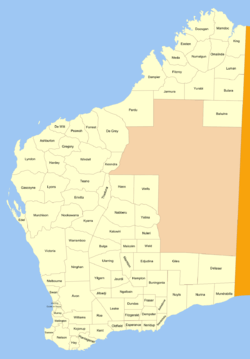
Wells Land District is a land district (cadastral division) of Western Australia, located within the Eastern Land Division of the state. It spans roughly 24°00'S - 26°20'S in latitude and 121°40'E - 123°20'E in longitude. Its name honours Lawrence Allen Wells, an explorer of the area in 1896–1897.[1]
| Wells Western Australia | |||||||||||||||
|---|---|---|---|---|---|---|---|---|---|---|---|---|---|---|---|
 | |||||||||||||||
| Region | Mid West | ||||||||||||||
| |||||||||||||||
It lies to the north of Lake Carnegie, and part of the Canning Stock Route passes through the north-west of the district.
The district was created on 30 January 1925 and was defined in the Government Gazette:[2]
Bounded by lines starting due East from the 547-mile post on the surveyed line of the No.1 Rabbit-proof Fence and due North from survey mark F. 46 at the Weld Springs, and extending East to a point due North from the summit of Kyffin Thomas Hill; thence South to the centre of Lake Wells; thence North-Westerly and Westerly along the centre of the said lake and the centres of Lakes Dorothena, Carnegie and Rudall, and the centre of the Charles Wells Creek to a point due South from the starting point, and hence due North to the said starting point.
References
- Steele, Christopher (1990). "Wells, Lawrence Allen (1860 - 1938)". Australian Dictionary of Biography. Melbourne University Press. ISSN 1833-7538. Retrieved 7 December 2010 – via National Centre of Biography, Australian National University. Also "Index Map of Western Australia", Department of Lands and Surveys, 1949.
- "The Land Act, 1898. New Land Districts. (per 7835/97)". Western Australia Government Gazette. 30 January 1925. p. 1925:129.