Wang Sam Mo District
Wang Sam Mo (Thai: วังสามหมอ, pronounced [wāŋ sǎːm mɔ̌ː]) is a district (amphoe) in southeastern Udon Thani Province, northeastern Thailand.
Wang Sam Mo วังสามหมอ | |
|---|---|
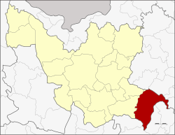 District location in Udon Thani Province | |
| Coordinates: 16°56′59″N 103°25′43″E | |
| Country | Thailand |
| Province | Udon Thani |
| Seat | Phasuk |
| Area | |
| • Total | 727.3 km2 (280.8 sq mi) |
| Population (2005) | |
| • Total | 55,730 |
| • Density | 76.6/km2 (198/sq mi) |
| Time zone | UTC+7 (ICT) |
| Postal code | 41280 |
| Geocode | 4110 |
Geography
Neighboring districts are (from the west clockwise) Si That and Chai Wan of Udon Thani Province, Waritchaphum, Nikhom Nam Un, and Kut Bak of Sakon Nakhon Province and Kham Muang, Sam Chai, and Nong Kung Si and Tha Khantho of Kalasin Province.
History
The minor district (king amphoe) Wang Sam Mo was established on 1 October 1975, when the three tambons Nong Kung Thap Ma, Ba Yao, and Nong Ya Sai were split off from Si That District.[1] It was upgraded to a full district on 13 July 1981.[2]
Administration
The district is divided into six sub-districts (tambons), which are further subdivided into 72 villages (mubans). Wang Sam Mo is a sub-district municipality (thesaban tambon) which covers parts of tambon Wang Sam Mo. Phasuk is a sub-district municipality which covers the whole same-named tambon. There are a further five tambon administrative organizations (TAO).
| No. | Name | Thai | Villages | Pop.[3] |
|---|---|---|---|---|
| 1. | Nong Kung Thap Ma | หนองกุงทับม้า | 11 | 7,922 |
| 2. | Nong Ya Sai | หนองหญ้าไซ | 9 | 7,649 |
| 3. | Ba Yao | บะยาว | 12 | 9,441 |
| 4. | Phasuk | ผาสุก | 18 | 15,421 |
| 5. | Kham Khok Sung | คำโคกสูง | 9 | 5,615 |
| 6. | Wang Sam Mo | วังสามหมอ | 13 | 11,683 |
References
- ประกาศกระทรวงมหาดไทย เรื่อง แบ่งท้องที่อำเภอศรีธาตุ จังหวัดอุดรธานี ตั้งเป็นกิ่งอำเภอวังสามหมอ (PDF). Royal Gazette (in Thai). 92 (202 ง): 2412. September 30, 1975.
- พระราชกฤษฎีกาตั้งอำเภอหนองใหญ่ อำเภอบ่อไร่ อำเภอพรหมคีรี อำเภอนาบอน อำเภอบางสะพานน้อย อำเภอนาดี อำเภอกงหรา อำเภอวังทรายพูน อำเภอธารโต อำเภอคำตากล้า อำเภอศรีนคร อำเภอด่านช้าง อำเภอพรเจริญ อำเภอวังสามหมอ และอำเภอลานสัก พ.ศ. ๒๕๒๔ (PDF). Royal Gazette (in Thai). 98 (115 ก Special): 7–10. July 13, 1981.
- "Population statistics 2012". Department of Provincial Administration.