Vulcan (inactive volcano)
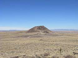
Vulcan, named after the Roman god of fire, is an inactive volcano on Albuquerque, New Mexico's West Mesa. It is the largest of the volcanoes in Albuquerque's Volcanic Field . Vulcan is a spatter cone, formed primarily by fire fountains that were active in the central vent and in smaller vents on flanks of the cone. These flank vents formed the arches and caves seen today. From a vantage point on top of the cone 600 feet above valley floor, the alignment of the 5-mile-long chain of vents is particularly noticeable.[1] (Spatter forms when blobs of lava are emitted from a vent and cool as they fly through the air, and the partially molten blobs then land on the side of the cone to weld together to form a hard crust.) Fragmented cinder and spatter material and lava flows dip at angles as high as 55° away from the central vent on the eastern and southern side of Vulcan. The spatter material is thickest on the southeastern side of Vulcan, indicating that it was blown by the wind toward the south and east during the fountaining events. A solidified lava pond that consists of a massive gray basalt with weakly developed columnar jointing occupies the crater of Vulcan. Radial, sinuous lava tubes 8 to 20 inches across and 300 feet long are preserved on the northeast and northwest flanks of Vulcan.[2][3]
| Vulcan | |
|---|---|
 Vulcan Volcano | |
| Highest point | |
| Elevation | 6,033 ft (1,839 m) |
| Prominence | 600 ft (180 m) |
| Geography | |
| Location | Petroglyph National Monument Bernalillo County, New Mexico, US |
| Geology | |
| Age of rock | > 10,000 years |
| Mountain type | Stratovolcano |
| Last eruption | 150,000+ years ago |
Vulcan lies in a large geological zone known as the Rio Grande rift, which follows the Rio Grande from southern Colorado through El Paso, Texas, after which it becomes indistinguishable from the Range and Basin province of northern Mexico. This rent in the Earth's surface, where two land masses are pulling away from one another, is responsible for much of the volcanic activity and mountain-building that occurred throughout the area.
Vulcan lies in Petroglyph National Monument, with access to the volcanoes during business hours, after which any vehicles are locked in and subject to fines and impound. It rests in a volcanic field approximately 7 mi. northwest of Albuquerque. To the south are the volcanoes Black, followed by JA volcano. To the north lie Bond and Butte volcanoes and the Jemez Mountains. To the west is the giant stratovolcano Mount Taylor (Navajo: Tsoodził, The Turquoise Mountain), and to the east are the cities of Rio Rancho, Albuquerque, the village of Corrales, and the Sandia Mountains.
Vulcan is believed to have last erupted around 150,000 years ago. It was once believed to be extinct. After Earth and space-based geodetic measurements indicated ongoing surface uplift above the Socorro Magma Body at approximately 2 mm/year, it was reclassified as inactive or dormant.[4]
References
- , US National Monuments.
- Smith, G.A., Florence, P.S., Castounis, A.D., Luongo, M., Moore, J.D., Throne, J., Zelley, K., 1999, Basaltic near-vent faces of Vulcan Cone, Albuquerque volcanoes, New Mexico New Mexico Geological Society Guidebook 50, p. 211-219..
- , New Mexico Bureau of Geology and Mineral Resources.
- , Magma Uplift in New Mexico.