Vredefort crater
The Vredefort crater /ˈvrɛdəfɜːrt/ is the largest verified impact crater on Earth. More than 300 kilometres (190 mi) across when it was formed,[1][2] what remains of it is in the present-day Free State province of South Africa. It is named after the town of Vredefort, which is near its centre. Although the crater itself has long since been eroded away, the remaining geological structures at its centre are known as the Vredefort Dome or Vredefort impact structure. The crater is calculated to be 2.023 billion years old (± 4 million years), with impact being in the Paleoproterozoic Era. It is the third-oldest known crater on Earth.
| Vredefort Dome (centre) | |
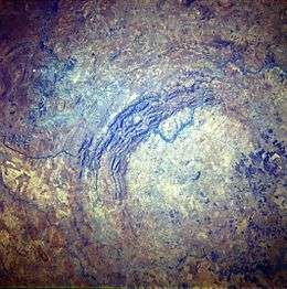 Vredefort Dome, seen from space by STS-51-I | |
| Impact crater/structure | |
|---|---|
| Confidence | Confirmed |
| Diameter | 300 km (190 mi) |
| Age | 2,023 ± 4 Ma Paleoproterozoic |
| Exposed | Yes |
| Drilled | Yes |
| Location | |
| Coordinates | 27°0′0″S 27°30′0″E |
| Country | South Africa |
| Province | Free State |
 Location of Vredefort crater | |
| Official name | Vredefort Dome |
| Includes |
|
| Criteria | Natural: (viii) |
| Reference | 1162 |
| Inscription | 2005 (29th session) |
| Area | 30,000 ha (120 sq mi) |
In 2005, the Vredefort Dome was added to the list of UNESCO World Heritage sites for its geologic interest.
Formation and structure


The asteroid that hit Vredefort is estimated to have been one of the largest ever to strike Earth (at least since the Hadean Eon some four billion years ago), thought to have been approximately 10–15 km (6.2–9.3 mi) in diameter.[3] The bolide that created the Sudbury Basin could have been even larger.[4]
The original crater is estimated to have had a diameter of roughly 300 km (190 mi),[2] but that has been eroded. It would have been larger than the 250 km (160 mi) Sudbury Basin and the 180 km (110 mi) Chicxulub crater. The remaining structure, the "Vredefort Dome", consists of a partial ring of hills 70 km (43 mi) in diameter, and is the remains of a dome created by the rebound of rock below the impact site after the collision.
The crater's age is estimated to be 2.023 billion years (± 4 million years),[1] which places it in the Paleoproterozoic Era. It is the second-oldest known crater on Earth, a little less than 300 million years younger than the Suavjärvi crater in Russia. In comparison, it is about 10% older than the Sudbury Basin impact (at 1.849 billion years).
The dome in the centre of the crater was originally thought to have been formed by a volcanic explosion, but in the mid-1990s, evidence revealed it was the site of a huge bolide impact, as telltale shatter cones were discovered in the bed of the nearby Vaal River.
The crater site is one of the few multiple-ringed impact craters on Earth, although they are more common elsewhere in the Solar System. Perhaps the best-known example is Valhalla crater on Jupiter's moon Callisto. Earth's Moon has some as well. Geological processes, such as erosion and plate tectonics, have destroyed most multiple-ring craters on Earth.
The impact distorted the Witwatersrand Basin which was laid down over a period of 250 million years between 950 and 700 million years before the Vredefort impact. The overlying Ventersdorp lavas and the Transvaal Supergroup which were laid down between 700 and 80 million years before the meteorite strike, were similarly distorted by the formation of the 300-kilometre-wide (190 mi) crater.[3][5] The rocks form partial concentric rings around the crater centre today, with the oldest, the Witwatersrand rocks, forming a semicircle 25 km (16 mi) from the centre. Since the Witwatersrand rocks consist of several layers of very hard, erosion-resistant sediments (e.g. quartzites and banded ironstones),[3][6] they form the prominent arc of hills that can be seen to the northwest of the crater centre in the satellite picture above. The Witwatersrand rocks are followed, in succession, by the Ventersdorp lavas at a distance of about 35 km (22 mi) from the centre, and the Transvaal Supergroup, consisting of a narrow band of the Ghaap Dolomite rocks and the Pretoria Subgroup of rocks, which together form a 25-to-30-kilometre-wide (16 to 19 mi) band beyond that.[7]
From about halfway through the Pretoria Subgroup of rocks around the crater centre, the order of the rocks is reversed. Moving outwards towards where the crater rim used to be, the Ghaap Dolomite group resurfaces at 60 km (37 mi) from the centre, followed by an arc of Ventersdorp lavas, beyond which, at between 80 and 120 km (50 and 75 mi) from the centre, the Witwatersrand rocks re-emerge to form an interrupted arc of outcrops today. The Johannesburg group is the most famous one because it was here that gold was discovered in 1886.[3][7] It is thus possible that if it had not been for the Vredefort impact this gold would never have been discovered.[3]
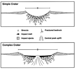
The 40-kilometre-diameter (25 mi) centre of the Vredefort crater consists of a granite dome (where it is not covered by much younger rocks belonging to the Karoo Supergroup) which is an exposed part of the Kaapvaal craton, one of the oldest microcontinents which formed on Earth 3.9 billion years ago.[3] This central peak uplift, or dome, is typical of a complex impact crater, where the liquefied rocks splashed up in the wake of the meteor as it penetrated the surface.
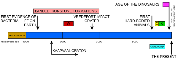 A timeline of the Earth's history indicating when the Vredefort crater was formed in relation to some of the other important South African geological events. W indicates when the Witwatersrand Supergroup was laid down, C the Cape Supergroup, and K the Karoo Supergroup. The graph also indicates the period during which banded ironstone formations were formed on earth, indicative of an oxygen-free atmosphere. The Earth's crust was wholly or partially molten during the Hadean Eon. One of the first microcontinents to form was the Kaapvaal Craton, which is exposed at the centre of the Vredefort Dome, and again north of Johannesburg.
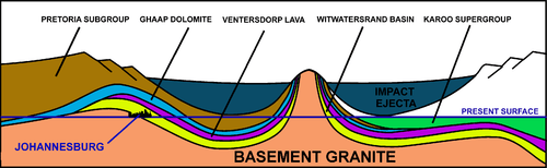 A schematic diagram of a NE (left) to SW (right) cross-section through the 2.020-billion-year-old Vredefort impact crater and how it distorted the contemporary geological structures. The present erosion level is shown. Johannesburg is where the Witwatersrand Basin (the yellow layer) is exposed at the "present surface" line, just inside the crater rim, on the left. Not to scale.
Conservation

The Vredefort Dome World Heritage Site is currently subject to property development, and local owners have expressed concern regarding sewage dumping into the Vaal River and the crater site.[8] The granting of prospecting rights around the edges of the crater has led environmental interests to express fear of destructive mining.
Community
The Vredefort Dome in the centre of the crater is home to four towns: Parys, Vredefort, Koppies and Venterskroon. Parys is the largest and a tourist hub; both Vredefort and Koppies mainly depend on an agricultural economy.
On 19 December 2011, a broadcasting license was granted by ICASA to a community radio station to broadcast for the Afrikaans- and English-speaking members of the communities within the crater. The Afrikaans name Koepel Stereo (Dome Stereo) refers to the dome and announces its broadcast as KSFM. The station broadcasts on 94.9 MHz FM.
References
- "Vredefort". Earth Impact Database. Planetary and Space Science Centre University of New Brunswick Fredericton. Retrieved 2008-12-30.
- "Deep Impact - The Vredefort Dome". Hartebeesthoek Radio Astronomy Observatory. 2006-08-01. Retrieved 2007-09-19.
- McCarthy, T., Rubridge, B. (2005). "The Story of Earth and Life". p. 89–90, 102–107, 134–136. Struik Publishers, Cape Town
- "The Vredefort Dome: Centre of the World's Largest Meteorite Impact Structure!". Archived from the original on 31 December 2011. Retrieved 31 December 2012.
- Norman, N., Whitfield, G. (2006) ‘’Geological Journeys’’. pp. 38–49, 60–61. Struik Publishers, Cape Town.
- Truswell, J. F. (1977). The Geological Evolution of South Africa. pp. 23–38. Purnell, Cape Town
- Geological map of South Africa, Lesotho and Swaziland (1970). Council for Geoscience, Geological Survey of South Africa.
- Momberg, Eleanor (23 August 2009). "River heading for the rocks". Retrieved 22 March 2011.
External links
| Wikimedia Commons has media related to Vredefort Dome. |
- Parys South Africa
- Impact Cratering Research Group – University of the Witwatersrand
- Earth Impact Database
- Deep Impact – The Vredefort Dome
- Satellite image of Vredefort crater from Google Maps
- Impact Cratering: an overview of Mineralogical and Geochemical aspects – University of Vienna
- Google Earth 3d .KMZ of 25 largest craters (requires Google Earth)
For official site names, see each article or the List of World Heritage Sites in South Africa. | ||
| ||