Vorukh
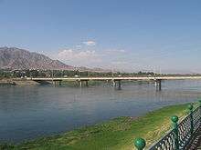
Vorukh is a jamoat in northern Tajikistan. It is an exclave surrounded by Kyrgyzstan that forms part of the Isfara District in Sughd province. As of 2009, the jamoat had a total population of 23,121.[1]
Vorukh Ворух | |
|---|---|
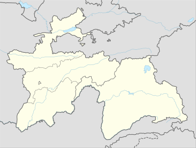 Vorukh Location in Tajikistan | |
| Coordinates: 39°51′12″N 70°34′37″E | |
| Country | |
| Province | Sughd |
| District | Isfara District |
| Population | |
| • Total | 23,121 |
| Time zone | UTC+5 (TJT) |
History and territorial conflicts
Vorukh is the name of a village and one of two exclaves of Tajikistan within the Batken Province of Kyrgyzstan. There are three Tajik enclaves (including the Sarvan exclave surrounded by Uzbekistan), which were products of several border adjustments during the Stalin regime of the 1920s to 1950s.
Due to the inherent territorial restrictions of the exclave, violent conflicts over land ownership, access to pasture, and shared water resources have become more common, as logistical complications within this densely populated and impoverished region have also given rise to economic concern.
The location of the border of the enclave is disputed by the Tajik and Kyrgyz governments.[2] In April 2013 an argument between Vorukh residents and Kyrgyz labourers escalated into a fight, ultimately involving several hundred people, when Vorukh residents objected to the building of a new road that would bypass the enclave. In May 2013 Kyrgyzstan and Tajik officials met to address the ongoing tensions.[3]
Climate
Köppen-Geiger climate classification system classifies its climate as dry-summer continental (Dsa).[4]
| Climate data for Vorukh | |||||||||||||
|---|---|---|---|---|---|---|---|---|---|---|---|---|---|
| Month | Jan | Feb | Mar | Apr | May | Jun | Jul | Aug | Sep | Oct | Nov | Dec | Year |
| Average high °C (°F) | 0.0 (32.0) |
2.1 (35.8) |
8.6 (47.5) |
17.0 (62.6) |
22.4 (72.3) |
27.9 (82.2) |
30.7 (87.3) |
29.7 (85.5) |
24.8 (76.6) |
17.0 (62.6) |
8.5 (47.3) |
2.3 (36.1) |
15.9 (60.7) |
| Daily mean °C (°F) | −4.2 (24.4) |
−2.1 (28.2) |
4.1 (39.4) |
11.4 (52.5) |
16.0 (60.8) |
20.6 (69.1) |
23.0 (73.4) |
21.8 (71.2) |
16.7 (62.1) |
10.3 (50.5) |
3.6 (38.5) |
−1.5 (29.3) |
10.0 (49.9) |
| Average low °C (°F) | −8.3 (17.1) |
−6.3 (20.7) |
−0.3 (31.5) |
5.9 (42.6) |
9.7 (49.5) |
13.3 (55.9) |
15.4 (59.7) |
13.9 (57.0) |
8.7 (47.7) |
3.7 (38.7) |
−1.3 (29.7) |
−5.2 (22.6) |
4.1 (39.4) |
| Average precipitation mm (inches) | 53 (2.1) |
51 (2.0) |
79 (3.1) |
71 (2.8) |
69 (2.7) |
21 (0.8) |
11 (0.4) |
4 (0.2) |
6 (0.2) |
40 (1.6) |
39 (1.5) |
51 (2.0) |
495 (19.4) |
| Source: Climate-Data.org (altitude: 1379m)[4] | |||||||||||||
References
- "List of Jamoats". UN Coordination, Tajikistan. Archived from the original on July 16, 2011. Retrieved April 4, 2009.
- "Small Exclave Spells Big Problems For Kyrgyzstan, Tajikistan". Radio Free Europe Radio Liberty. Retrieved January 24, 2014.
- "Eurasian specialist warns that Central Asia's ethnic enclaves are 'heating up'". Stratrisks. Retrieved August 12, 2014.
- "Climate: Vorukh - Climate graph, Temperature graph, Climate table". Climate-Data.org. Retrieved 2014-01-18.
See also
- List of enclaves and exclaves
- Kayragach, the other Tajikistan exclave in Kyrgyzstan
- Sarvan, a Tajikistan exclave in Uzbekistan
- Shohimardon, an Uzbekistan exclave in Kyrgyzstan
- Sokh, an Uzbekistan exclave in Kyrgyzstan