Vilia
Vilia (Greek: Βίλια; formerly Eidyllia, Ειδυλλία) is a village and a former municipality of West Attica, Greece. Since the 2011 local government reform it is part of the municipality Mandra-Eidyllia, of which it is a municipal unit.[2] Its population was 1,753 at the 2011 census. It is part of Athens metropolitan area.[3]
Vilia Βίλια | |
|---|---|
 Vilia Location within the regional unit 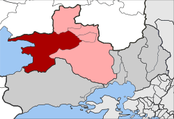 | |
| Coordinates: 38°10′N 23°20′E | |
| Country | Greece |
| Administrative region | Attica |
| Regional unit | West Attica |
| Municipality | Mandra-Eidyllia |
| • Municipal unit | 144.851 km2 (55.927 sq mi) |
| Elevation | 301 m (988 ft) |
| Population (2011)[1] | |
| • Municipal unit | 1,753 |
| • Municipal unit density | 12/km2 (31/sq mi) |
| Time zone | UTC+2 (EET) |
| • Summer (DST) | UTC+3 (EEST) |
| Postal code | 190 06 |
| Area code(s) | 22630 |
| Vehicle registration | Z |
| Website | www.vilia.org |
Geography
The municipal unit Vilia covers the mountainous northwestern part of Attica, and has a land area of 144.851 km².[4] The main mountain ranges are Cithaeron (1,409 m) in the northwest and Pastra in the northeast. In the west it stretches along the coast of the Alkyonides Gulf, a bay of the Gulf of Corinth. The village Vilia, the largest in the municipal unit, lies in the easternmost part, at the southeastern foot of Cithaeron. Vilia is 6 km south of Erythres, 7 km west of Oinoi, 10 km east of the coastal village Aigosthena, 17 km south of Thebes and 40 km northwest of Athens.
The municipal unit's largest villages are Vilia (pop. 1,269 in 2011), Kato Alepochori (220), Aigosthena (80), Veniza (52), and Agios Nektarios (40).
Subdivisions
The municipal unit Vilia consists of the following villages:
- Vilia
- Agia Paraskevi
- Agios Konstantinos
- Agios Nektarios
- Aigosthena (also Porto Germeno)
- Ano Alepochori
- Veniza
- Kato Alepochori
- Kryo Pigadi
- Loumpa
- Mytikas
- Profitis Ilias
- Psatha
Historical population
| Year | Town population | Municipal unit population |
|---|---|---|
| 1981 | 2,427 | - |
| 1991 | 1,912 | 3,412 |
| 2001 | 1,955 | 3,215 |
| 2011 | 1,269 | 1,753 |
Notable people
- Ellie Lambeti (1926–1983) actress
References
- "Απογραφή Πληθυσμού - Κατοικιών 2011. ΜΟΝΙΜΟΣ Πληθυσμός" (in Greek). Hellenic Statistical Authority.
- Kallikratis law Greece Ministry of Interior (in Greek)
- https://worldpopulationreview.com/world-cities/athens-population/
- "Population & housing census 2001 (incl. area and average elevation)" (PDF) (in Greek). National Statistical Service of Greece. Archived from the original (PDF) on 2015-09-21.
External links
- Official website (in Greek)
- West Attica
- Historical references of the town of Vilia
- Vilia (municipality) on GTP Travel Pages (in English and Greek)