Plataies
Plataies (Greek: Πλαταιές), anciently Kokhla,[2][3][4] is a village and a former municipality in Boeotia, Greece. Since the 2011 local government reform it is part of the municipality Thebes, of which it is a municipal unit.[5] The municipal unit has an area of 172.533 km2, the community 37.321 km2.[6] Population 4,908 (2011). The seat of the former municipality was in Kaparelli.

View of Plataies and surrounding area from above.

Ruins of Plataea.
Plataies Πλαταιές | |
|---|---|
 City of Plataies, near the ruins of old Plataea. Location of the 479 BCE Battle of Plataea. | |
 Plataies Location within the regional unit 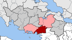 | |
| Coordinates: 38°14′N 23°13′E | |
| Country | Greece |
| Administrative region | Central Greece |
| Regional unit | Boeotia |
| Municipality | Thebes |
| • Municipal unit | 172.533 km2 (66.615 sq mi) |
| Population (2011)[1] | |
| • Municipal unit | 4,908 |
| • Municipal unit density | 28/km2 (74/sq mi) |
| Community | |
| • Population | 947 (2011) |
| • Area (km2) | 37.321 |
| Time zone | UTC+2 (EET) |
| • Summer (DST) | UTC+3 (EEST) |
| Vehicle registration | ΒΙ |
The village is next to the ruins of the ancient city of Plataea and near the site of the Battle of Plataea.
See also
References
- "Απογραφή Πληθυσμού - Κατοικιών 2011. ΜΟΝΙΜΟΣ Πληθυσμός" (in Greek). Hellenic Statistical Authority.
- Perdicaris, G. A. (1846). The Greece of the Greeks. Paine & Burgess. p. 127.
- 19th century map
- Smith, James Reuel (1922). Springs and wells in Greek and Roman literature, their legends and locations. New York, G. P. Putnam's sons. p. 198.
- Kallikratis law Greece Ministry of Interior (in Greek)
- "Population & housing census 2001 (incl. area and average elevation)" (PDF) (in Greek). National Statistical Service of Greece.
This article is issued from Wikipedia. The text is licensed under Creative Commons - Attribution - Sharealike. Additional terms may apply for the media files.