Vestvågøy
Vestvågøy is a municipality in Nordland county, Norway. It is part of the traditional district of Lofoten. The administrative centre of the municipality is the town of Leknes. Some of the villages in the municipality include Ballstad, Borg, Bøstad, Gravdal, Knutstad, Stamsund, and Tangstad. With over 11,300 inhabitants, Vestvågøy is the most populous municipality in all of the Lofoten and Vesterålen regions in Nordland county.
Vestvågøy kommune | |
|---|---|
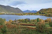
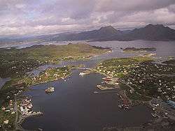 View of Ballstad in Vestvågøy | |
 Coat of arms 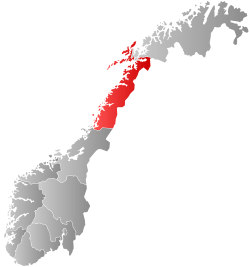 Nordland within Norway | |
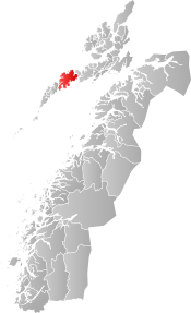 Vestvågøy within Nordland | |
| Coordinates: 68°13′17″N 13°47′04″E | |
| Country | Norway |
| County | Nordland |
| District | Lofoten |
| Established | 1 Jan 1963 |
| Administrative centre | Leknes |
| Government | |
| • Mayor (2015) | Remi Solberg (Ap) |
| Area | |
| • Total | 424.56 km2 (163.92 sq mi) |
| • Land | 406.95 km2 (157.12 sq mi) |
| • Water | 17.61 km2 (6.80 sq mi) 4.1% |
| Area rank | 232 in Norway |
| Population (2020) | |
| • Total | 11,433 |
| • Rank | 99 in Norway |
| • Density | 28.1/km2 (73/sq mi) |
| • Change (10 years) | 7.1% |
| Demonym(s) | Vestvågøyværing[1] |
| Time zone | UTC+01:00 (CET) |
| • Summer (DST) | UTC+02:00 (CEST) |
| ISO 3166 code | NO-1860 |
| Official language form | Neutral[2] |
| Website | vestvagoy |
The Lofotr museum in Borg shows a reconstructed Iron Age Viking chieftain's residence, with a house measuring 80 metres (262 ft), built of stone and turf.
The 425-square-kilometre (164 sq mi) municipality is the 232nd largest by area out of the 356 municipalities in Norway. Vestvågøy is the 99th most populous municipality in Norway with a population of 11,433. The municipality's population density is 28.1 inhabitants per square kilometre (73/sq mi) and its population has increased by 7.1% over the previous 10-year period.[3][4]
General information
The municipality of Vestvågøy was created on 1 January 1963 when the four municipalities on the island of Vestvågøya were merged into one municipality for the whole island. The old municipalities on the island were Borge (population: 4,056), Buksnes (population: 4,416), Hol (population: 3,154), and Valberg (population: 662). Initially, Vestvågøy had 12,288 residents. The borders have not changed since.[5]
Name
The municipality is named after the island of Vestvågøya. The Old Norse name of the island was Lófót (see Lofoten) - but when Lofoten became the name of the whole archipelago, the old name was replaced with Vestvågøy. Vestvågøy can be broken down into three parts: vest-våg-øy which can be roughly translated as west-bay-island.
Coat of arms
The coat of arms is from modern times; they were granted on 7 September 1984. The arms show two dried codfish in white on a blue background. This was chosen since the municipality is one of the main Norwegian exporters of (dried) cod or stockfish and has been since the Middle Ages.[6]
Churches
The Church of Norway has five parishes (sokn) within the municipality of Vestvågøy. It is part of the Lofoten prosti (deanery) in the Diocese of Sør-Hålogaland.
| Parish (Sokn) | Church Name | Location of the Church | Year Built |
|---|---|---|---|
| Borge | Borge Church | Bøstad | 1986 |
| Knutstad Chapel | Knutstad | 1915 | |
| Buksnes | Buksnes Church | Gravdal | 1905 |
| Hol | Hol Church | Leknes | 1806 |
| Stamsund | Stamsund Church | Stamsund | 1937 |
| Valberg | Valberg Church | Valberg | 1889 |
Geography
Vestvågøy municipality is among the most scenic in Norway. It encompassed the whole island of Vestvågøya with the Norwegian Sea to the north and the Vestfjorden to the south. The island has rugged cliffs and peaks facing the southeastern coast. Towards the northwest, however, the land is flat, with extensive farmlands. Most people are found in the town of Leknes and in its "twin town" Gravdal, where Nordland Hospital is located. Along the southeastern coast, one finds picturesque fishing villages like Ballstad and Stamsund, where the Hurtigruten (coastal ferry) stops.
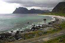
The coastline is dominated by high mountains, such as the 671-metre (2,201 ft) tall Skottinden, and on the west coast also sandy white beaches. Uttakleiv the most romantic beach in Europe, according to the British newspaper The Times, and the neighbouring Hauklandsstranden is ranked by the Norwegian newspaper Dagbladet as the best beach in Norway.
In Leknes, the sun (midnight sun) is above the horizon from May 26 until July 17, and in winter the sun does not rise from December 9 until January 4. The midnight sun is best viewed from the western beaches, such as Uttakleiv and Eggum.
Climate
| Climate data for Kvalnes, on northern Vestvågøya | |||||||||||||
|---|---|---|---|---|---|---|---|---|---|---|---|---|---|
| Month | Jan | Feb | Mar | Apr | May | Jun | Jul | Aug | Sep | Oct | Nov | Dec | Year |
| Average high °C (°F) | 1.8 (35.2) |
1.4 (34.5) |
2.1 (35.8) |
4.4 (39.9) |
8.6 (47.5) |
12.2 (54.0) |
14.1 (57.4) |
14.0 (57.2) |
10.8 (51.4) |
7.3 (45.1) |
4.2 (39.6) |
2.5 (36.5) |
7.0 (44.6) |
| Daily mean °C (°F) | −0.2 (31.6) |
−0.3 (31.5) |
0.4 (32.7) |
2.6 (36.7) |
6.5 (43.7) |
9.5 (49.1) |
11.5 (52.7) |
11.9 (53.4) |
8.9 (48.0) |
5.7 (42.3) |
2.5 (36.5) |
0.5 (32.9) |
5.0 (41.0) |
| Average low °C (°F) | −2.5 (27.5) |
−2.8 (27.0) |
−2.0 (28.4) |
0.2 (32.4) |
3.8 (38.8) |
7.2 (45.0) |
9.5 (49.1) |
9.7 (49.5) |
6.9 (44.4) |
3.5 (38.3) |
0.3 (32.5) |
−1.8 (28.8) |
2.7 (36.9) |
| Average precipitation mm (inches) | 117 (4.6) |
93 (3.7) |
89 (3.5) |
70 (2.8) |
48 (1.9) |
50 (2.0) |
71 (2.8) |
68 (2.7) |
111 (4.4) |
153 (6.0) |
126 (5.0) |
139 (5.5) |
1,135 (44.7) |
| Average precipitation days (≥ 1.0 mm) | 16.2 | 14.2 | 15.1 | 11.7 | 8.9 | 9.9 | 11.5 | 11.0 | 15.8 | 18.0 | 18.2 | 17.7 | 168.2 |
| Source: Norwegian Meteorological Institute[7] | |||||||||||||
Government
All municipalities in Norway, including Vestvågøy, are responsible for primary education (through 10th grade), outpatient health services, senior citizen services, unemployment and other social services, zoning, economic development, and municipal roads. The municipality is governed by a municipal council of elected representatives, which in turn elect a mayor.[8] The municipality falls under the Lofoten District Court and the Hålogaland Court of Appeal.
Municipal council
The municipal council (Kommunestyre) of Vestvågøy is made up of 33 representatives that are elected to four year terms. The party breakdown of the council is as follows:
| Party Name (in Norwegian) | Number of representatives | |
|---|---|---|
| Labour Party (Arbeiderpartiet) | 8 | |
| Progress Party (Fremskrittspartiet) | 5 | |
| Green Party (Miljøpartiet De Grønne) | 1 | |
| Conservative Party (Høyre) | 4 | |
| Christian Democratic Party (Kristelig Folkeparti) | 2 | |
| Red Party (Rødt) | 1 | |
| Centre Party (Senterpartiet) | 10 | |
| Socialist Left Party (Sosialistisk Venstreparti) | 2 | |
| Total number of members: | 33 | |
| Party Name (in Norwegian) | Number of representatives | |
|---|---|---|
| Labour Party (Arbeiderpartiet) | 11 | |
| Progress Party (Fremskrittspartiet) | 3 | |
| Green Party (Miljøpartiet De Grønne) | 1 | |
| Conservative Party (Høyre) | 8 | |
| Christian Democratic Party (Kristelig Folkeparti) | 2 | |
| Centre Party (Senterpartiet) | 5 | |
| Socialist Left Party (Sosialistisk Venstreparti) | 2 | |
| Liberal Party (Venstre) | 1 | |
| Total number of members: | 33 | |
| Party Name (in Norwegian) | Number of representatives | |
|---|---|---|
| Labour Party (Arbeiderpartiet) | 10 | |
| Progress Party (Fremskrittspartiet) | 4 | |
| Green Party (Miljøpartiet De Grønne) | 1 | |
| Conservative Party (Høyre) | 10 | |
| Christian Democratic Party (Kristelig Folkeparti) | 3 | |
| Centre Party (Senterpartiet) | 4 | |
| Socialist Left Party (Sosialistisk Venstreparti) | 2 | |
| Liberal Party (Venstre) | 1 | |
| Total number of members: | 35 | |
| Party Name (in Norwegian) | Number of representatives | |
|---|---|---|
| Labour Party (Arbeiderpartiet) | 8 | |
| Progress Party (Fremskrittspartiet) | 5 | |
| Conservative Party (Høyre) | 8 | |
| Christian Democratic Party (Kristelig Folkeparti) | 4 | |
| Coastal Party (Kystpartiet) | 1 | |
| Centre Party (Senterpartiet) | 6 | |
| Socialist Left Party (Sosialistisk Venstreparti) | 2 | |
| Vestvågøy list (Vestvågøylista) | 1 | |
| Total number of members: | 35 | |
| Party Name (in Norwegian) | Number of representatives | |
|---|---|---|
| Labour Party (Arbeiderpartiet) | 7 | |
| Progress Party (Fremskrittspartiet) | 6 | |
| Conservative Party (Høyre) | 3 | |
| Christian Democratic Party (Kristelig Folkeparti) | 4 | |
| Coastal Party (Kystpartiet) | 1 | |
| Centre Party (Senterpartiet) | 6 | |
| Socialist Left Party (Sosialistisk Venstreparti) | 4 | |
| Joint list of the Red Electoral Alliance (Rød Valgallianse) and the Communist Party (Kommunistiske Parti) | 1 | |
| Vestvågøy list (Vestvågøylista) | 3 | |
| Total number of members: | 35 | |
| Party Name (in Norwegian) | Number of representatives | |
|---|---|---|
| Labour Party (Arbeiderpartiet) | 7 | |
| Progress Party (Fremskrittspartiet) | 6 | |
| Conservative Party (Høyre) | 3 | |
| Christian Democratic Party (Kristelig Folkeparti) | 6 | |
| Coastal Party (Kystpartiet) | 1 | |
| Centre Party (Senterpartiet) | 6 | |
| Socialist Left Party (Sosialistisk Venstreparti) | 2 | |
| Joint list of the Red Electoral Alliance (Rød Valgallianse) and the Communist Party (Kommunistiske Parti) | 1 | |
| Vestvågøy list (Vestvågøylista) | 3 | |
| Total number of members: | 35 | |
| Party Name (in Norwegian) | Number of representatives | |
|---|---|---|
| Labour Party (Arbeiderpartiet) | 5 | |
| Progress Party (Fremskrittspartiet) | 5 | |
| Conservative Party (Høyre) | 3 | |
| Christian Democratic Party (Kristelig Folkeparti) | 6 | |
| Centre Party (Senterpartiet) | 11 | |
| Socialist Left Party (Sosialistisk Venstreparti) | 1 | |
| Vestvågøy list (Vestvågoylista) | 4 | |
| Total number of members: | 35 | |
| Party Name (in Norwegian) | Number of representatives | |
|---|---|---|
| Labour Party (Arbeiderpartiet) | 9 | |
| Progress Party (Fremskrittspartiet) | 2 | |
| Conservative Party (Høyre) | 7 | |
| Christian Democratic Party (Kristelig Folkeparti) | 5 | |
| Pensioners' Party (Pensjonistpartiet) | 1 | |
| Centre Party (Senterpartiet) | 12 | |
| Socialist Left Party (Sosialistisk Venstreparti) | 4 | |
| Hol and Valberg district list (Hol og Valberg Distriktliste) | 3 | |
| Total number of members: | 43 | |
| Party Name (in Norwegian) | Number of representatives | |
|---|---|---|
| Labour Party (Arbeiderpartiet) | 13 | |
| Progress Party (Fremskrittspartiet) | 2 | |
| Conservative Party (Høyre) | 9 | |
| Christian Democratic Party (Kristelig Folkeparti) | 6 | |
| Pensioners' Party (Pensjonistpartiet) | 1 | |
| Centre Party (Senterpartiet) | 5 | |
| Socialist Left Party (Sosialistisk Venstreparti) | 2 | |
| Hol and Valberg district list (Hol og Valberg distriktsliste) | 5 | |
| Total number of members: | 43 | |
| Party Name (in Norwegian) | Number of representatives | |
|---|---|---|
| Labour Party (Arbeiderpartiet) | 15 | |
| Progress Party (Fremskrittspartiet) | 1 | |
| Conservative Party (Høyre) | 8 | |
| Christian Democratic Party (Kristelig Folkeparti) | 5 | |
| Centre Party (Senterpartiet) | 7 | |
| Socialist Left Party (Sosialistisk Venstreparti) | 1 | |
| Liberal Party (Venstre) | 1 | |
| For the referendum (For Folkeavstemning) | 1 | |
| Hol and Valberg district list (Hol og Valberg distriktslista) | 4 | |
| Total number of members: | 43 | |
| Party Name (in Norwegian) | Number of representatives | |
|---|---|---|
| Labour Party (Arbeiderpartiet) | 15 | |
| Progress Party (Fremskrittspartiet) | 2 | |
| Conservative Party (Høyre) | 8 | |
| Christian Democratic Party (Kristelig Folkeparti) | 7 | |
| Centre Party (Senterpartiet) | 6 | |
| Socialist Left Party (Sosialistisk Venstreparti) | 1 | |
| Liberal Party (Venstre) | 1 | |
| Hol and Valberg district list (Hol og Valberg distriktsliste) | 3 | |
| Total number of members: | 43 | |
| Party Name (in Norwegian) | Number of representatives | |
|---|---|---|
| Labour Party (Arbeiderpartiet) | 16 | |
| Anders Lange's Party (Anders Langes parti) | 3 | |
| Conservative Party (Høyre) | 5 | |
| Christian Democratic Party (Kristelig Folkeparti) | 8 | |
| Centre Party (Senterpartiet) | 9 | |
| Socialist Left Party (Sosialistisk Venstreparti) | 1 | |
| Liberal Party (Venstre) | 1 | |
| Total number of members: | 43 | |
| Party Name (in Norwegian) | Number of representatives | |
|---|---|---|
| Labour Party (Arbeiderpartiet) | 18 | |
| Conservative Party (Høyre) | 5 | |
| Christian Democratic Party (Kristelig Folkeparti) | 4 | |
| Centre Party (Senterpartiet) | 8 | |
| Socialist People's Party (Sosialistisk Folkeparti) | 1 | |
| Liberal Party (Venstre) | 1 | |
| Local List(s) (Lokale lister) | 6 | |
| Total number of members: | 43 | |
| Party Name (in Norwegian) | Number of representatives | |
|---|---|---|
| Labour Party (Arbeiderpartiet) | 17 | |
| Conservative Party (Høyre) | 7 | |
| Christian Democratic Party (Kristelig Folkeparti) | 3 | |
| Centre Party (Senterpartiet) | 7 | |
| Socialist People's Party (Sosialistisk Folkeparti) | 2 | |
| Liberal Party (Venstre) | 2 | |
| Local List(s) (Lokale lister) | 5 | |
| Total number of members: | 43 | |
| Party Name (in Norwegian) | Number of representatives | |
|---|---|---|
| Labour Party (Arbeiderpartiet) | 24 | |
| Conservative Party (Høyre) | 10 | |
| Christian Democratic Party (Kristelig Folkeparti) | 4 | |
| Centre Party (Senterpartiet) | 9 | |
| Socialist People's Party (Sosialistisk Folkeparti) | 1 | |
| Liberal Party (Venstre) | 3 | |
| Local List(s) (Lokale lister) | 2 | |
| Total number of members: | 53 | |
Transportation
%2C_Vestv%C3%A5g%C3%B8y_municipality%2C_Lofoten%2C_Nordland%2C_Norway.JPG)
Leknes is the municipal and administrative centre and is situated in the geographical middle of Lofoten, approximately 68 kilometres (42 mi) west of Svolvær and 65 kilometres (40 mi) east of Å. Leknes is the trading and shopping centre of Lofoten, only rivaled by Svolvær. Leknes Airport is for smaller aircraft, with 7 daily scheduled flights to Bodø and some daily flights to Svolvær and Røst with Widerøe airlines. There is a small bus terminal which serves as a hub with bus links to the rest of Lofoten. The Leknes Havn (harbor) is one of Norway's most important and visited harbors for cruise ships. The coastal steamer has been an important means of communication for a century. It docks in Stamsund twice every night, one heading south towards Bodø the other heading north towards Svolvær.
The European route E10 highway crosses the municipality (and island) with the Sundklakkstraumen Bridge connecting to Vågan in the north and the Nappstraumen Tunnel connecting to Flakstad in the south.
International relations
Media gallery
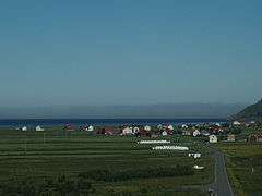 Unstad; Vestvågøy has the largest areas of lowland in Lofoten
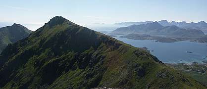 View south-west from the summit of Bulitinden
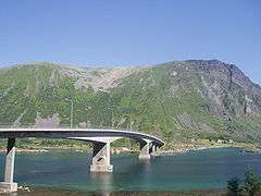 Sundklakkstraumen Bridge
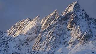 The mountain Skottinden in winter sunshine
Notable residents
- Guri Ingebrigtsen (1952–2020), politician
References
- "Navn på steder og personer: Innbyggjarnamn" (in Norwegian). Språkrådet.
- "Forskrift om målvedtak i kommunar og fylkeskommunar" (in Norwegian). Lovdata.no.
- Statistisk sentralbyrå (2020). "Table: 06913: Population 1 January and population changes during the calendar year (M)" (in Norwegian).
- Statistisk sentralbyrå (2020). "09280: Area of land and fresh water (km²) (M)" (in Norwegian).
- Jukvam, Dag (1999). "Historisk oversikt over endringer i kommune- og fylkesinndelingen" (PDF) (in Norwegian). Statistisk sentralbyrå.
- "Civic heraldry of Norway - Norske Kommunevåpen". Heraldry of the World. Retrieved 2018-12-18.
- "eKlima Web Portal". Norwegian Meteorological Institute. Archived from the original on 2004-06-14.
- Hansen, Tore, ed. (2016-05-12). "kommunestyre". Store norske leksikon (in Norwegian). Kunnskapsforlaget. Retrieved 2018-12-18.
- "Tall for Norge: Kommunestyrevalg 2019 - Nordland". Valg Direktoratet. Retrieved 2019-10-28.
- "Table: 04813: Members of the local councils, by party/electoral list at the Municipal Council election (M)" (in Norwegian). Statistics Norway.
- "Tall for Norge: Kommunestyrevalg 2011 - Nordland". Valg Direktoratet. Retrieved 2019-10-28.
- "Kommunestyrevalget 1995" (PDF) (in Norwegian). Oslo-Kongsvinger: Statistisk sentralbyrå. 1996. Retrieved 2020-03-18.
- "Kommunestyrevalget 1991" (PDF) (in Norwegian). Oslo-Kongsvinger: Statistisk sentralbyrå. 1993. Retrieved 2020-03-18.
- "Kommunestyrevalget 1987" (PDF) (in Norwegian). Oslo-Kongsvinger: Statistisk sentralbyrå. 1988. Retrieved 2020-03-18.
- "Kommunestyrevalget 1983" (PDF) (in Norwegian). Oslo-Kongsvinger: Statistisk sentralbyrå. 1984. Retrieved 2020-03-18.
- "Kommunestyrevalget 1979" (PDF) (in Norwegian). Oslo: Statistisk sentralbyrå. 1979. Retrieved 2020-03-18.
- "Kommunevalgene 1975" (PDF) (in Norwegian). Oslo: Statistisk sentralbyrå. 1977. Retrieved 2020-03-18.
- "Kommunevalgene 1972" (PDF) (in Norwegian). Oslo: Statistisk sentralbyrå. 1973. Retrieved 2020-03-18.
- "Kommunevalgene 1967" (PDF) (in Norwegian). Oslo: Statistisk sentralbyrå. 1967. Retrieved 2020-03-18.
- "Kommunevalgene 1963" (PDF) (in Norwegian). Oslo: Statistisk sentralbyrå. 1964. Retrieved 2020-03-18.
- "Twin municipalities Norway-Iceland" (in Norwegian). Norwegian government. Retrieved 24 April 2012.
External links
| Wikimedia Commons has media related to Vestvågøy. |

- Municipal fact sheet from Statistics Norway (in Norwegian)
 |
|  | |||||||||||||||||||||||||||||||||||
||
| Authority control |
|---|