Mo i Rana
Mo i Rana (Norwegian pronunciation: [ˈmuː i ˈrɑ̀ːnɑ]) is a town and the administrative centre of the municipality of Rana in Nordland county, Norway. It is located in the Helgeland region of Nordland, just south of the Arctic Circle. Some of the outlying areas of the town include the suburbs of Båsmoen and Ytteren in the north and Selfors in the east and Åga/Hauknes/Dalsgrenda in the south.
Mo i Rana Mo | |
|---|---|
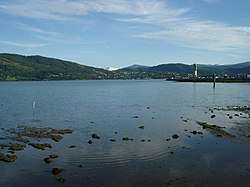 View of the town from the fjord in July 2003 | |
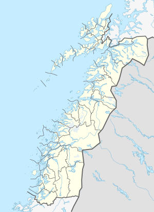 Mo i Rana Location of the town  Mo i Rana Mo i Rana (Norway) | |
| Coordinates: 66.3128°N 14.1428°E | |
| Country | Norway |
| Region | Northern Norway |
| County | Nordland |
| District | Helgeland |
| Municipality | Rana Municipality |
| Established | 1997 |
| Area | |
| • Total | 12.03 km2 (4.64 sq mi) |
| Elevation | 26 m (85 ft) |
| Population (2018)[1] | |
| • Total | 18,866 |
| • Density | 1,568/km2 (4,060/sq mi) |
| Demonym(s) | moværing |
| Time zone | UTC+01:00 (CET) |
| • Summer (DST) | UTC+02:00 (CEST) |
| Post Code | 8600 Mo i Rana |
| Former Municipality: | Mo ladested |
| Municipality ID | NO-1803 |
| Created from | Mo herred in 1923 |
| Merged into | Rana in 1964 |
| Area | 12 km2 (4.6 sq mi)[3] |
The town is called "Mo i Rana" to distinguish it from other places named Mo (including the town of Mosjøen, also in Helgeland) though locally the town is usually just called Mo. The postal address for Mo was "Mo 8600" until it was changed to "Mo i Rana 8600" in 1999.
The 12.03-square-kilometre (2,970-acre) town has a population (2018) of 18,866 and a population density of 1,568 inhabitants per square kilometre (4,060/sq mi).[1] This makes it the largest town in Helgeland and the second largest town (after Bodø) in Nordland county.
Name
The name Mo i Rana means "Mo in Rana" in Norwegian. "Mo" comes from an old farm that was situated near the modern town. The name of the farm comes from the Old Norse name Móar, which means sand or grass lowland. The name Rana probably comes from Old Norse too. Rana means quick or fast, probably because the fast water flow in the Ranfjorden outside town. The town was an old trade centre in Helgeland. Farmers have lived in the area since the Iron Age.[4]
History

Mining, building boats (Nordlands boats), and hunting/fishing used to be the main ways of life. Starting the summer 1730, there was a Sámi market in Mo. The market was held on the main church grounds until 1810. In 1860, wholesale merchant L.A. Meyer started a trade center, on license from the royal authority. Meyer traded flour, herring and tobacco, reindeer meat, skins and venison with the Swedes. The trade with Sweden increased, especially during Sweden's difficult economic years from 1892 to the start of the First World War. Many paths now used as hiking trails were originally trade paths for mountain dwellers in Sweden to Mo i Rana. One example is a path that starts in the Vindelfjällens Nature Reserve at Ammarnäs and follows the Vindel River valley then joins Vindelkroken and then crosses the Norwegian border to Mo i Rana.
The municipality is rich on iron ores, and water to produce power. This was very important in industry development. Dunderland Iron Ore Company (1902–1947) established the first mines in Storforshei (27 kilometres or 17 miles north of Mo i Rana). Rana Gruber was established in 1937, also a mining company. In 1946 the Norwegian Parliament approved plans for the construction of an Iron mill in Norway. The Parliament selected Mo i Rana. A/S Norwegian Iron Work Company was established. In 1955, the first steel was produced to Norway and other countries. The construction of the iron works took nine years.
During this period the village of Mo i Rana was changed to an industrial city. People from all over the country moved to Mo i Rana in order to obtain work. The community needed homes for thousands of new residents. Construction of houses and residential blocks started immediately. It was also established electricity and water supply to the city. In 1930, the population was 1300 people, this increased to 7,000 in 1955. In 1978 The Iron Mill employed approximately 4,500 of the 25,000 town's inhabitants.[5]
The Norwegian Parliament resolved in June 1988 to phase out state ownership of the company. Today there are 119 industrial companies at the industrial estate (Mo Industrial Park). The companies have activity in the iron and steel industry, the engineering industry, the research and development service industry and the information technology industry. In total, the companies employ approximately 1900 people.
From the end of the Second World War until the early 1990s, Mo i Rana, with the town's steel mill as its cornerstone, was dependent upon heavy industry. Following the decline of heavy industry, new service industries have now grown in the town.
Municipality
Rana Municipality was established on 1 January 1838 under the old formannskapsdistrikt law. Shortly afterwards, in 1839, the municipality was divided into Nord-Ranen and Sør-Ranen.[3] In 1844, Nord-Ranen was renamed Mo herred. On 1 January 1923, the village of Mo was designated as a ladested and so it was separated from the rest of the municipality to become a municipality of its own. The new town of Mo (population: 1,305) kept the name Mo and the rest of the old municipality became known as Nord-Rana (bringing back the old name for the area).
During the 1960s, there were many municipal mergers across Norway due to the work of the Schei Committee. On 1 January 1964, the municipality of Nord-Rana (population: 11,636) was merged with the town of Mo i Rana (population: 9,616), the part of the municipality of Sør-Rana located north of the Ranfjorden (population: 697), and the Sjona area of Nesna Municipality (population: 543) to create the large, new Rana Municipality.[6]
The "Graveyard War" in 1951
During the autumn of 1951, around "700 or 800" protesters showed up at the local graveyard as a result of a "nighttime mobilization"[7] to oppose the government's attempt to remove Soviet corpses from graves. Some 93,000 Soviet POWs had been brought to Norway between 1941 and 1945 by the Germans to work on improvements to infrastructure in Norway. A 2013 article in Dagbladet says that "the protests were so powerful that [then minister of defence] Jens Chr. Hauge personally stopped the [government's] action".[7] (Only at this locality, was the government's Operation Asphalt stopped by civilians. More than 8000 Soviet corpses were removed from other graveyards in North Norway, without the government having decided the location of a new graveyard for these corpses.[7] The protests in Mo i Rana were not mentioned in national media during the Cold War.)
Government
Mo was a municipality from 1923 until 1964, and during that time, it was self-governing as a municipality. All municipalities in Norway, including Mo, are responsible for primary education (through 10th grade), outpatient health services, senior citizen services, unemployment and other social services, zoning, economic development, and municipal roads. The municipality is governed by a municipal council of elected representatives, which in turn elects a mayor.[8]
Municipal council
The municipal council (Bystyre) of Mo was made up of representatives that were elected to four year terms. The party breakdown of the final municipal council was as follows:
| Party Name (in Norwegian) | Number of representatives | |
|---|---|---|
| Labour Party (Arbeiderpartiet) | 18 | |
| Conservative Party (Høyre) | 4 | |
| Communist Party (Kommunistiske Parti) | 4 | |
| Christian Democratic Party (Kristelig Folkeparti) | 1 | |
| Liberal Party (Venstre) | 2 | |
| Total number of members: | 29 | |
| Party Name (in Norwegian) | Number of representatives | |
|---|---|---|
| Labour Party (Arbeiderpartiet) | 15 | |
| Conservative Party (Høyre) | 4 | |
| Communist Party (Kommunistiske Parti) | 6 | |
| Liberal Party (Venstre) | 3 | |
| Local List(s) (Lokale lister) | 1 | |
| Total number of members: | 29 | |
| Party Name (in Norwegian) | Number of representatives | |
|---|---|---|
| Labour Party (Arbeiderpartiet) | 15 | |
| Conservative Party (Høyre) | 3 | |
| Communist Party (Kommunistiske Parti) | 6 | |
| Liberal Party (Venstre) | 3 | |
| Local List(s) (Lokale lister) | 1 | |
| Total number of members: | 28 | |
| Party Name (in Norwegian) | Number of representatives | |
|---|---|---|
| Labour Party (Arbeiderpartiet) | 9 | |
| Conservative Party (Høyre) | 3 | |
| Communist Party (Kommunistiske Parti) | 6 | |
| Liberal Party (Venstre) | 2 | |
| Total number of members: | 20 | |
| Party Name (in Norwegian) | Number of representatives | |
|---|---|---|
| Labour Party (Arbeiderpartiet) | 7 | |
| Communist Party (Kommunistiske Parti) | 7 | |
| Joint List(s) of Non-Socialist Parties (Borgerlige Felleslister) | 3 | |
| Local List(s) (Lokale lister) | 3 | |
| Total number of members: | 20 | |
| Party Name (in Norwegian) | Number of representatives | |
|---|---|---|
| Labour Party (Arbeiderpartiet) | 11 | |
| Joint List(s) of Non-Socialist Parties (Borgerlige Felleslister) | 8 | |
| Local List(s) (Lokale lister) | 1 | |
| Total number of members: | 20 | |
| Party Name (in Norwegian) | Number of representatives | |
|---|---|---|
| Labour Party (Arbeiderpartiet) | 9 | |
| Communist Party (Kommunistiske Parti) | 1 | |
| Liberal Party (Venstre) | 3 | |
| Local List(s) (Lokale lister) | 1 | |
| Non-Socialist Group (Borgerlig Samling) | 6 | |
| Total number of members: | 20 | |
Geography and climate
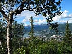
Mo i Rana is located at the head of Ranfjorden, just on the southern side of the Saltfjellet mountains with the Svartisen glacier, Norway's second largest. The river Ranelva meets the Ranfjorden in Mo i Rana. Rana and Saltfjellet are famous for their numerous caves. Two of the caves are open to the public, Grønligrotta and Setergrotta. Mo i Rana is situated about 80 kilometres (50 mi) south of the Arctic Circle.
| Nerdal/ Mo i Rana (1961–90) | ||||||||||||||||||||||||||||||||||||||||||||||||||||||||||||
|---|---|---|---|---|---|---|---|---|---|---|---|---|---|---|---|---|---|---|---|---|---|---|---|---|---|---|---|---|---|---|---|---|---|---|---|---|---|---|---|---|---|---|---|---|---|---|---|---|---|---|---|---|---|---|---|---|---|---|---|---|
| Climate chart (explanation) | ||||||||||||||||||||||||||||||||||||||||||||||||||||||||||||
| ||||||||||||||||||||||||||||||||||||||||||||||||||||||||||||
| ||||||||||||||||||||||||||||||||||||||||||||||||||||||||||||
Mo i Rana's climate is usually classified as subarctic (Köppen Dfc bordering on Dsc),[16] with long, cold winters, and short, warm summers. However it's very mild compared to Oymyakon, Russia and Verkhoyansk, Russia which are continental subarctic climates. The Norwegian Current (extension of Gulf Stream), follows the coastline of Norway all the way north. The stream has a heavy influence on the climate, helping to keep the temperatures from getting too low in the winter, despite the city being located about 70 kilometres (43 mi) from the coast line. The distance from the coast, however, does give it slightly lower temperatures in the winter than towns nearer the coast. There is much precipitation due to the mountains north of town, often with much snow in winter. The weather can be very unpredictable, and change quickly. Blizzards can go on for hours, potentially creating traffic difficulties and cancelling flights. Because of Mo i Rana's latitude, summer days are very long and winter days are very short on daylight. In the winter season, the Northern Lights can be seen on the night sky. It varies in intensity, coloured from white green to deep red, and comes in different shapes, such as beams, arches and draperies.
The summer is short; July and August are the warmest months. The 24-hr average temperature in July is 13.2 °C (55.8 °F).[17] This is based on the 1961–1990 base period; recent years have tended to be warmer in this area. There are usually two to three warm periods during the summer, when the average temperature is between 20 and 26 °C (68 and 79 °F) at daytime. The warm days may last for 2–14 days, with the temperature peaking at 31 °C (88 °F). Occasionally, the temperatures stay over 20 °C (68 °F) even at night time, a phenomenon called tropenatt in Norwegian.
Autumn begins in September. The trees lose their leaves in October, and the flowers disappear. During November, fresh water and rivers start to freeze, and the landscape is covered with snow. Only the spruce forest stays green throughout the winter. In the winter, the sun is low on the horizon, and is only visible for a few hours. Heating through sunlight is limited because of Mo i Rana's high-latitude location. Mountains block the sunlight when the sun is low on the horizon, which means that the sun is not visible at all during the month of December. There are normally two to three very cold periods in the winter with temperature dipping close to minus 30 °C. The cold periods normally last 3–7 days. But in the summer has midnight sun and there is no polar night in December at all. Average precipitation is 1400 mm/year.[17]
| Climate data for Mo i Rana (1961–90) | |||||||||||||
|---|---|---|---|---|---|---|---|---|---|---|---|---|---|
| Month | Jan | Feb | Mar | Apr | May | Jun | Jul | Aug | Sep | Oct | Nov | Dec | Year |
| Average high °C (°F) | −2.7 (27.1) |
−1.8 (28.8) |
1.6 (34.9) |
5.3 (41.5) |
11.6 (52.9) |
15.9 (60.6) |
17.7 (63.9) |
16.4 (61.5) |
11.3 (52.3) |
6.1 (43.0) |
1.2 (34.2) |
−1.1 (30.0) |
6.8 (44.2) |
| Average low °C (°F) | −8.1 (17.4) |
−7.1 (19.2) |
−4.4 (24.1) |
−0.9 (30.4) |
3.5 (38.3) |
7.8 (46.0) |
10.3 (50.5) |
9.3 (48.7) |
5.7 (42.3) |
1.9 (35.4) |
−3.5 (25.7) |
−6.4 (20.5) |
0.7 (33.2) |
| Average precipitation mm (inches) | 146 (5.7) |
117 (4.6) |
112 (4.4) |
74 (2.9) |
64 (2.5) |
70 (2.8) |
97 (3.8) |
110 (4.3) |
155 (6.1) |
186 (7.3) |
136 (5.4) |
163 (6.4) |
1,430 (56.2) |
| Source: http://met.no/Klima/Klimastatistikk/Klimadata/ | |||||||||||||
Industry
Norsk Jernverk, established in 1946, produced steel for the country until 1988, when it was divided into several new companies. The iron mill had a significant impact on the town development. In 1978, the city's population had grown from approximately 2000 to 25,000. Mo Industrial Park is one of Norway's largest industrial parks. It is important for the local society, giving work to approximately 1900 people. The iron and steel factory Jernverket consumes more power than the entire Oslo municipality. The National Library of Norway has a division in Mo i Rana. HelgelandsKraft supplies electric power to the Helgeland region. NRK (Norwegian Broadcasting Corporation) has a division in Mo i Rana. Rana Blad and Rana No Are the towns local newspapers. Radio 3 Rana is the local radio station.
Transport
Mo i Rana has a regional airport, Mo i Rana Airport, Røssvoll, situated 10 kilometres (6.2 mi) north of the city in Røssvoll. The airport is a part of the Norwegian STOLport network. Mo i Rana is connected to the Nordland Line railway. This is a railway line between Trondheim and Bodø. The main north-south road in Norway, European route E6, passes through the city. The European route E12 begins in Mo i Rana and connect the city to Sweden and Finland. A bus network runs throughout most of the city and its suburbs.
An international tourist route Blue Highway (in Norwegian: Blå vegen) begins in Mo i Rana. The route goes via Sweden and Finland to Russia.
Culture
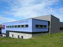
Havmann (English: The Man from the Sea) is a sculpture made from Arctic granite located in the Ranfjord. It was made in 1995 by the English sculptor Antony Gormley. It is a part of Artscape Nordland, which can be seen from the city centre. The festival Havmanndagene is held in the town every year in May. Nordland Theater is a regional theater that tours in Nordland. It was established in 1979, and is situated in a new theater building with three stages. Rana Museum, department of Helgeland Museum, is situated in the city centre. The main exhibit focuses on everyday life in the town in the 20th century. It has a photo gallery with about 80,000 images, and a folk music archive. The museum also contains a miniature model of the city from around 1930. Natural History museum is situated in the old part of town, known as Moholmen. It focuses on exhibitions of the animal life in the region. The county library of Nordland is situated in Mo i Rana. Arctic Circle Raceway is a motorsports and road racing track, situated 30 kilometres (19 mi) north of Mo i Rana.
Churches
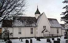
Mo Church is the oldest building in Mo i Rana. Built in 1724, it is made of wood and has 400 seats. The church was built on the initiative of Thomas von Westen, a Norwegian priest and missionary who worked among the Sami. Numerous victims of World War II are buried in the graveyard, which receives visitors from the entire world in search of relatives. Gruben Church is another church in Mo i Rana. It was built in 1965 to serve the growing town.
International relations
Twin towns – Sister cities
Mo i Rana is twinned with:


See also
- Blue Highway, tourist route
References
- Statistisk sentralbyrå (1 January 2018). "Urban settlements. Population and area, by municipality".
- "Mo i Rana, Rana (Nordland)". yr.no. Retrieved 9 February 2019.
- Thorsnæs, Geir, ed. (18 September 2016). "Nord-Rana". Store norske leksikon (in Norwegian). Kunnskapsforlaget. Retrieved 16 September 2018.
- Rygh, Oluf (1905). Norske gaardnavne: Nordlands amt (in Norwegian) (16 ed.). Kristiania, Norge: W. C. Fabritius & sønners bogtrikkeri. p. 13.
- no:Norsk Jernverk
- Jukvam, Dag (1999). "Historisk oversikt over endringer i kommune- og fylkesinndelingen" (PDF) (in Norwegian). Statistisk sentralbyrå.
- "60 års taushet og tristesse". Dagbladet. 4 July 2013.
- Hansen, Tore, ed. (12 May 2016). "kommunestyre". Store norske leksikon (in Norwegian). Kunnskapsforlaget. Retrieved 2 February 2020.
- "Kommunevalgene og Ordførervalgene 1959" (PDF) (in Norwegian). Oslo: Statistisk sentralbyrå. 1960. Retrieved 18 March 2020.
- "Kommunevalgene og Ordførervalgene 1955" (PDF) (in Norwegian). Oslo: Statistisk sentralbyrå. 1957. Retrieved 18 March 2020.
- "Kommunevalgene og Ordførervalgene 1951" (PDF) (in Norwegian). Oslo: Statistisk sentralbyrå. 1952. Retrieved 18 March 2020.
- "Kommunevalgene og Ordførervalgene 1947" (PDF) (in Norwegian). Oslo: Statistisk sentralbyrå. 1948. Retrieved 18 March 2020.
- "Kommunevalgene og Ordførervalgene 1945" (PDF) (in Norwegian). Oslo: Statistisk sentralbyrå. 1947. Retrieved 18 March 2020.
- "Kommunevalgene og Ordførervalgene 1937" (PDF) (in Norwegian). Oslo: Statistisk sentralbyrå. 1938. Retrieved 18 March 2020.
- "Kommunevalgene og Ordførervalgene 1934" (PDF) (in Norwegian). Oslo: Statistisk sentralbyrå. 1935. Retrieved 18 March 2020.
- "World map of Köppen-Geiger climate classification". climate.gi.alaska.edu. University of Melbourne. Archived from the original on 25 March 2009. Retrieved 10 April 2009.
- met.no: Normaler for Rana Archived 11 March 2007 at the Wayback Machine
External links
| Wikimedia Commons has media related to Mo i Rana. |
- Rana municipality web pages
- Tourist information about the Arctic Circle area
- Image gallery of Mo i Rana
- moirana.com – local portal for Mo i Rana
As of 1 January 2019, according to Statistics Norway | ||||||||
|  | |||||||
|
|  | |||||||||||||||||||||||||||||||||||
||
| Authority control |
|
|---|