Veghel
Veghel (Dutch pronunciation: [ˈvɛɣəl] (![]()
Veghel | |
|---|---|
Town and Former municipality | |
    _War_memorial.JPG)   From top down, left to right: market square of Veghel, former cantonal court and town hall, Klondike villa, Sacred Heart statue, Wiebenga silo, Airborne Monument, Saint Lambert Church, former Synagogue of Veghel | |
 Flag Coat of arms | |
.svg.png) Location in North Brabant | |
| Coordinates: 51°37′N 5°33′E | |
| Country | Netherlands |
| Province | North Brabant |
| Incorporated | 1310 |
| Market rights | 1719 |
| Area | |
| • Town | 78.92 km2 (30.47 sq mi) |
| • Land | 78.16 km2 (30.18 sq mi) |
| • Water | 0.76 km2 (0.29 sq mi) |
| Elevation | 10 m (30 ft) |
| Population | |
| • Town | 32,015 |
| • Urban | 53,680 |
| • Urban density | 2,272/km2 (5,880/sq mi) |
| • Metro region | 161,900 |
| Demonym(s) | Veghelaar |
| Time zone | UTC+1 (CET) |
| • Summer (DST) | UTC+2 (CEST) |
| Postcode | 5460–5469 |
| Area code | 0413 |
| Website | www |


History
The first settlements date back to Roman times and were established near the River Aa. The oldest written record of Veghel dates from 1225. It is a document of the Abbey of Berne, written in Latin on a piece of parchment, and describes several properties owned by the abbey. Among those is an estate located in the settlement of "Vehchele".
In 1310, John II of Brabant granted the inhabitants the right to use common grounds. For some decades in the 16th and 17th century the municipality was ruled by the Lords Van Erp, residing at their castle of Frisselsteijn in Veghel.
In 1648 Veghel became part of the Republic of the Seven United Netherlands. As a former part of the Duchy of Brabant, Veghel is situated in the Meierij of 's-Hertogenbosch. As a Catholic town, Veghel (like all the other areas of Brabant and Limburg which were transferred to the Netherlands by the Peace of Westphalia) suffered economic and religious oppression from the Protestant Dutch and was part of the military buffer zone of the Dutch Republic.
In 1719 Veghel became a market town, when it was granted market rights by the States General of the Netherlands, receiving the privilege of holding weekly markets and four annual fairs. However, it was not until the French wars of 1795 that Veghel formally received freedom of religion again and received a guarantee of full common rights from the Dutch government. In 1810 Veghel became part of the Kingdom of the Netherlands. From the middle of the 19th century the agrarian market town began developing into an industrial town as a consequence of the opening of the South Willem's Canal. The construction of large-scale buildings like the neogothic church by Pierre Cuypers and the neoclassical town hall dates from that period. Monastic orders made Veghel a regional centre of health care and education, which it remains to this day.
In 1940 Veghel was occupied by German troops. With the beginning of Operation Market Garden in 1944 Veghel was one of the dropping-places for Allied paratroops owing to its strategic location.
The period since the 1950s has seen much growth, with the development of new industries and the establishment in Veghel of several international companies (e.g. Mars, Incorporated, FrieslandCampina, DMV International, Agrifirm, Kuehne + Nagel, DHL Supply Chain, Alliance Healthcare, ThyssenKrupp and Vanderlande Industries). Its shopping centre and marketplace earned the town the name of "Pearl of the Meierij". Veghel is an educational centre for the surrounding district with several secondary schools, a senior secondary vocational school, and one of the oldest higher vocational schools in the area: the Pedagogic Academy, which was founded in 1872.
Since 1994, Veghel and the neighbouring town of Erp have formed a single municipality.
Demographics
Towns
Population figures as of 1 January 2015, ranked by size:[7]
| Town | Population | Density |
| Veghel (nl) | 31,032 | 730/km2 |
| Erp | 6,743 | 189/km2 |
Population centres
Population figures as of 1 January 2015, ranked by size:[7]
| Urban core | Population | Density |
| Veghel | 26,491 | 1063/km2 |
| Erp | 4,761 | 239/km2 |
| Zijtaart | 1,727 | 173/km2 |
| Mariaheide | 1,449 | 355/km2 |
| Eerde | 1,365 | 387/km2 |
| Keldonk | 1,204 | 112/km2 |
| Boerdonk | 778 | 157/km2 |
Language
The spoken language by the native population is North Meierijs (an East Brabantian dialect, which is very similar to colloquial Dutch).[8]
Nationalities
Compared to other towns in the region, the ethnic makeup of Veghel is relatively diverse.[9] More than 22% of the town's population, or 17% of the municipality's population, is of foreign origin.[10] In total, Veghel is home to people of more than a hundred different nationalities.[11] About 90% of the municipality's total foreign population lives inside the town proper of Veghel.[12]
| Largest foreign ethnic groups (2015)[10][11] | |
| Nationality | Population |
|---|---|
| 1,457 | |
| 806 | |
| 662 | |
| 585 | |
| 526 | |
| 372 | |
| 181 | |
| 167 | |
| 149 | |
| 139 | |
| 121 | |
| 100 | |
Local festivals
Every November sees the celebration of the entry of St Nicholas (Sinterklaas). Every two year in June or July The Slokdarmfestival takes place. On 1 September the harbour festival takes place. In February or March the traditional carnival is held.
Attractions
- The neogothic church of St Lambert and its graveyard containing war graves
- The neorenaissance former town hall
- The neogothic former synagogue (recently rebuilt)
- The Protestant church
- The monastery of the order of the Franciscans with its gardens and church
Notable residents
- Anky van Grunsven, Dressage champion.
- Dillianne van den Boogaard, Former Netherlands international field hockey player.
- Earnie Stewart, Former United States international soccer player.
- Theo Lucius, Former professional footballer for PSV Eindhoven and Feyenoord.
- Theo Maassen, Comedian and actor.
Gallery
 Town Hall of Veghel
 Villa Klondike, former headquarters of the 501st Parachute Infantry Regiment (101st Airborne Division)
 Statue of the Sacred Heart of Jesus at the marina square
 Franciscan Sisters nunnery
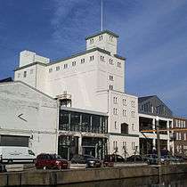
 Inland port of Veghel
 Inland port of Veghel
 Boxtel-Wesel railway
.JPG) Railroad crossing the Aa river
Railroad crossing the Aa river
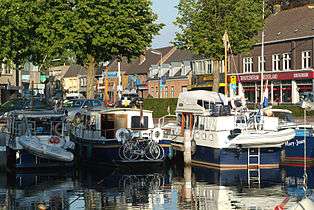 Marina of Veghel
 Marina of Veghel during the entry parade of Sinterklaas, 16 November 2014
References
- "Kerncijfers wijken en buurten" [Key figures for neighbourhoods]. CBS Statline (in Dutch). CBS. 2 July 2013. Retrieved 12 March 2014.
- "Postcodetool for 5461KN". Actueel Hoogtebestand Nederland (in Dutch). Het Waterschapshuis. Retrieved 6 June 2014.
- "Bevolkingsontwikkeling; regio per maand" [Population growth; regions per month]. CBS Statline (in Dutch). CBS. 1 January 2019. Retrieved 1 January 2019.
- "Kerncijfers wijken en buurten 2010" [Key figures for neighbourhoods 2010]. CBS Statline; Urban area (in Dutch). CBS. 1 January 2010. Retrieved 10 December 2014.
- "Kerncijfers wijken en buurten 2014" [Key figures for neighbourhoods 2014]. CBS Statline; Metro region (in Dutch). CBS. 1 January 2014. Retrieved 2 September 2015.
- CBS. "In twintig jaar bijna 240 gemeenten minder". www.cbs.nl (in Dutch). Retrieved 2016-12-30.
- "Population per centre as of 01-01-2015". Municipality of Veghel. 1 January 2015. Retrieved 24 April 2015.
- Jos & Cor Swanenberg: Taal in stad en land: Oost-Brabants, ISBN 9012090105
- "1e + 2e generatie allochtonen (incl. Westerse) per duizend inwoners" [1st & 2nd-generation immigrants (inc. Westerners) per capita]. Brabant databank (in Dutch). Province of North Brabant. 1 January 2014. Retrieved 1 January 2015.
- "Kerncijfers voor bevolking; leeftijd, herkomstgroepering, geslacht en regio" [Key figures for population; age, ethnic background, gender and region]. CBS Statline (in Dutch). CBS. 1 January 2015. Retrieved 14 August 2015.
- "Buitenlandse nationaliteiten in Veghel per 01-01-2015" [Foreign nationalities in Veghel by 1/1/2015] (in Dutch). Municipality of Veghel. 1 January 2015. Retrieved 1 January 2016.
- "Kerncijfers wijken en buurten 2015" [Key figures for neighbourhoods 2015]. CBS Statline (in Dutch). CBS. 1 January 2015. Retrieved 30 November 2015.
External links

- Official website
Places adjacent to Veghel | |
|---|---|