Eerde
Eerde is a village in the Dutch province of North Brabant. It is part of the municipality of Veghel, located about 500 m west of the built-up area of Veghel and 3 km southwest of the town centre of Veghel.[2] During Operation Market Garden, in September 1944, it changed hands several times between German and American forces but ended up in American hands; the village was severely damaged in the process.
%2C_church%2C_front_view.JPG)
St. Anthony Abbot Church in Eerde
Eerde | |
|---|---|
_church%2C_side_view.JPG) 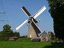 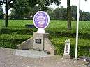 From top down, left to right: St. Anthony Abbot Church St. Anyhony Mill, Airborne monument 'Geronimo' | |
 Eerde | |
| Coordinates: 51°36′12.3″N 5°29′51.2″E | |
| Country | Netherlands |
| Province | North Brabant |
| Municipality | Veghel |
| Population (2015)[1] | |
| • Village | 1,050 |
| • Statistical area • Density | 1,365 387/km2 (1,000/sq mi) |
| • Post town • Density | 31,032 730/km2 (1,900/sq mi) |
| Time zone | UTC+1 (CET) |
| • Summer (DST) | UTC+2 (CEST) |
| Post town (BAG) | Veghel |
| Postcode | 5460 |
| Area code | 0413 |
| Major roads | A50, N622 |
References
- "Population per centre as of 01-01-2015". Municipality of Veghel. 1 January 2015. Retrieved 24 April 2015.
- ANWB Topografische Atlas Nederland, Topografische Dienst and ANWB, 2005.
This article is issued from Wikipedia. The text is licensed under Creative Commons - Attribution - Sharealike. Additional terms may apply for the media files.