Valbondione
Valbondione (Bergamasque: Valbundiù) is a comune (municipality) in the Province of Bergamo in the Italian region of Lombardy, located about 90 kilometres (56 mi) northeast of Milan and about 45 kilometres (28 mi) north of Bergamo. It is surrounded by the Orobie Alps. As of 31 December 2004, it had a population of 1,156 and an area of 95.0 square kilometres (36.7 sq mi).[3]
Valbondione | |
|---|---|
| Comune di Valbondione | |
 Valbondione | |
Location of Valbondione 
| |
 Valbondione Location of Valbondione in Italy 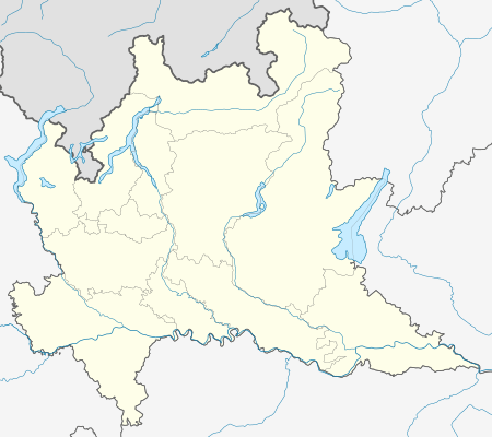 Valbondione Valbondione (Lombardy) | |
| Coordinates: 46°6′N 9°47′E | |
| Country | Italy |
| Region | Lombardy |
| Province | Province of Bergamo (BG) |
| Frazioni | Fiumenero, Lizzola Alta , Lizzola Bassa , Bondione, Maslana , Gavazzo , Dossi |
| Area | |
| • Total | 95.0 km2 (36.7 sq mi) |
| Elevation | 900 m (3,000 ft) |
| Population (Dec. 2004)[2] | |
| • Total | 1,156 |
| • Density | 12/km2 (32/sq mi) |
| Demonym(s) | Valbondionesi |
| Time zone | UTC+1 (CET) |
| • Summer (DST) | UTC+2 (CEST) |
| Postal code | 24020 |
| Dialing code | 0346 |

Aerial view of Valbondione
The municipality of Valbondione contains the frazioni (subdivisions, mainly villages and hamlets) Fiumenero, Lizzola Alta, Lizzola Bassa, Bondione, Maslana, Gavazzo, and Dossi.
Valbondione borders the following municipalities: Carona, Gandellino, Gromo, Piateda, Ponte in Valtellina, Teglio, Vilminore di Scalve.
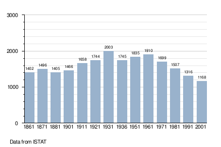
Demographic evolution
References
- "Superficie di Comuni Province e Regioni italiane al 9 ottobre 2011". Istat. Retrieved 16 March 2019.
- "Popolazione Residente al 1° Gennaio 2018". Istat. Retrieved 16 March 2019.
- All demographics and other statistics: Italian statistical institute Istat.
This article is issued from Wikipedia. The text is licensed under Creative Commons - Attribution - Sharealike. Additional terms may apply for the media files.