Val-Morin, Quebec
Val-Morin is a municipality in the Laurentides region of Quebec, Canada, part of the Les Laurentides Regional County Municipality.
Val-Morin | |
|---|---|
Municipality | |
 | |
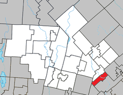 Location within Les Laurentides RCM | |
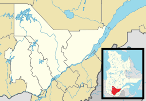 Val-Morin Location in central Quebec | |
| Coordinates: 46°00′N 74°11′W[1] | |
| Country | |
| Province | |
| Region | Laurentides |
| RCM | Les Laurentides |
| Settled | 1850s |
| Constituted | June 27, 1922 |
| Government | |
| • Mayor | Serge St-Hilaire |
| • Federal riding | Laurentides—Labelle |
| • Prov. riding | Bertrand |
| Area | |
| • Total | 41.00 km2 (15.83 sq mi) |
| • Land | 39.41 km2 (15.22 sq mi) |
| Elevation | 309 m (1,014 ft) |
| Population (2011)[3] | |
| • Total | 2,772 |
| • Density | 70.3/km2 (182/sq mi) |
| • Pop 2006-2011 | |
| • Dwellings | 1,963 |
| Time zone | UTC−5 (EST) |
| • Summer (DST) | UTC−4 (EDT) |
| Postal code(s) | J0T 2R0 |
| Area code(s) | 819 |
| Highways | |
| Website | www |
Geography
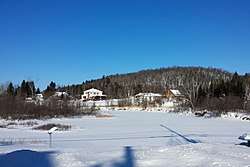
Val-Morin is located in the Laurentian Mountains, along the Rivière du Nord and on the shores of Lake Raymond at an elevation of 309 metres (1,014 ft), about 15 kilometres (9.3 mi) south-east of Sainte-Agathe-des-Monts. Its territory includes numerous lakes such as La Salle, Lavallée, Bélair in the east, and Beauvais, Normand, and Valiquette in the west.[4]
History
The geographic area now called Val-Morin was likely inhabited by First Nations people either Montagnais-Naskapi, Algonkin or Cree prior to European settlement.[5]
In 1852, the Morin Township was formed. It was named after its founder and 19th-century politician Augustin-Norbert Morin (1803-1865) who already had a huge farm of more than 3 square kilometres (1.2 sq mi) on the banks of the Rivière du Nord, built around 1850-1860 and included a home, saw mill, and flour mill.[6] Morin was among the first residents and helped many settlers to settle here. In 1887, the Val-Morin Post Office opened, and in 1922, the Municipality of Val-Morin was established.[4]
Originally farmers, residents of Val-Morin have turned to the development of Alpine ski resorts and outdoor activities in recent times.[4]
Demographics
Population trend:[7]
- Population in 2011: 2772 (2006 to 2011 population change: 0.6%)
- Population in 2006: 2756
- Population in 2001: 2216
- Population in 1996: 2043
- Population in 1991: 1366
Private dwellings occupied by usual residents: 1298 (total dwellings: 1963)
Mother tongue:
- English as first language: 6.5%
- French as first language: 91.1%
- English and French as first language: 0.4%
- Other as first language: 2.0%
Economy
Val-Morin benefits from its close proximity to Montreal and the much traveled Highway 15. The "Le Petit Train du Nord" bike path and cross country ski trail and linear park cuts through Val-Morin bringing many cyclists and cross-country skiers through its territory. The Parc Dufresne regional park also attracts many hikers and cross-country skiers.
Education
Sainte Agathe Academy (of the Sir Wilfrid Laurier School Board) in Sainte-Agathe-des-Monts serves English-speaking students in this community for both elementary and secondary levels.[8]
References
- Reference number 64913 of the Commission de toponymie du Québec (in French)
- Geographic code 78005 in the official Répertoire des municipalités (in French)
- "(Code 2478005) Census Profile". 2011 census. Statistics Canada. 2012.
- "Val-Morin (Municipalité)" (in French). Commission de toponymie du Québec. Retrieved 2009-03-24.
- Jenifer S. H. Brown and C. Roderick Wilson (1986). "The Eastern Subarctic - A Regional Overview." In R. Bruce Morrison and C. Roderick Wilson (eds.) Native Peoples The Canadian Experience. Ontario: McClelland & Stewart Inc.
- "Morin-Heights (Municipalité)" (in French). Commission de toponymie du Québec. Retrieved 2009-03-16.
- Statistics Canada: 1996, 2001, 2006, 2011 census
- "About Us." Saint Agathe Academy. Retrieved on September 4, 2017. See Elementary zone map and Secondary zone map - Note that all areas covered in the elementary map are also covered in the secondary one.
External links

Places adjacent to Val-Morin, Quebec | ||||||||||
|---|---|---|---|---|---|---|---|---|---|---|
| ||||||||||
| Cities/towns | |
|---|---|
| Municipalities | |
| Townships | |
| Parishes | |
| Villages | |
| |