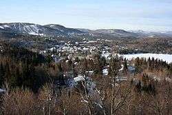
Saint-Faustin–Lac-Carré, Quebec
Saint-Faustin–Lac-Carré (French pronunciation: [sɛ̃ fostɛ̃ lak kaʁe]) is a municipality in the Laurentides region of Quebec, Canada, part of the Les Laurentides Regional County Municipality.
Saint-Faustin–Lac-Carré | |
|---|---|
Municipality | |
 | |
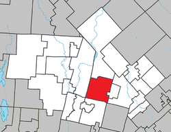 Location within Les Laurentides RCM. | |
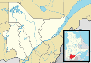 Saint-Faustin–Lac-Carré Location in central Quebec. | |
| Coordinates: 46°07′N 74°29′W[1] | |
| Country | |
| Province | |
| Region | Laurentides |
| RCM | Les Laurentides |
| Constituted | January 3, 1996 |
| Government | |
| • Mayor | Pierre Poirier |
| • Federal riding | Laurentides—Labelle |
| • Prov. riding | Labelle |
| Area | |
| • Total | 129.30 km2 (49.92 sq mi) |
| • Land | 121.28 km2 (46.83 sq mi) |
| Population (2011)[3] | |
| • Total | 3,467 |
| • Density | 28.6/km2 (74/sq mi) |
| • Pop 2006-2011 | |
| • Dwellings | 2,407 |
| Time zone | UTC−5 (EST) |
| • Summer (DST) | UTC−4 (EDT) |
| Postal code(s) | J0T 1J2 |
| Area code(s) | 819 |
| Highways | |
| Website | www.municipalite. stfaustin.qc.ca |
Demographics
Population trend:[4]
- Population in 2011: 3467 (2006 to 2011 population change: 16.1%)
- Population in 2006: 2985
- Population in 2001: 2790
- Population in 1996: 2470
- Lac-Carré: 861
- Saint-Faustin: 1609
- Population in 1991:
- Lac-Carré: 801
- Saint-Faustin: 1410
Private dwellings occupied by usual residents: 1558 (total dwellings: 2407)
Mother tongue:
- English as first language: 15.5%
- French as first language: 80.9%
- English and French as first language: 0.8%
- Other as first language: 3.7%
Education
Sainte Agathe Academy (of the Sir Wilfrid Laurier School Board) in Sainte-Agathe-des-Monts serves English-speaking students in this community for both elementary and secondary levels.[5]
See also
References
- Reference number 312947 of the Commission de toponymie du Québec (in French)
- Geographic code 78047 in the official Répertoire des municipalités (in French)
- "(Code 2478047) Census Profile". 2011 census. Statistics Canada. 2012.
- Statistics Canada: 1996, 2001, 2006, 2011 census
- "About Us." Saint Agathe Academy. Retrieved on September 4, 2017. See Elementary zone map and Secondary zone map - Note that all areas covered in the elementary map are also covered in the secondary one.
Places adjacent to Saint-Faustin–Lac-Carré, Quebec | ||||||||||
|---|---|---|---|---|---|---|---|---|---|---|
| ||||||||||
| Cities/towns | |
|---|---|
| Municipalities | |
| Townships | |
| Parishes | |
| Villages | |
| |
This article is issued from Wikipedia. The text is licensed under Creative Commons - Attribution - Sharealike. Additional terms may apply for the media files.