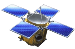
VERITAS (spacecraft)
VERITAS (Venus Emissivity, Radio Science, InSAR, Topography, and Spectroscopy) is a proposed mission concept by NASA's Jet Propulsion Laboratory (JPL) to map with high resolution the surface of planet Venus. The combination of topography, near-infrared spectroscopy, and radar image data would provide knowledge of Venus' tectonic and impact history, gravity, geochemistry, the timing and mechanisms of volcanic resurfacing, and the mantle processes responsible for them.
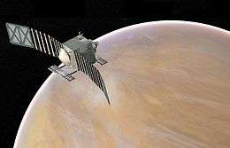 Artist's concept of Veritas at Venus | |
| Mission type | Reconnaissance |
|---|---|
| Operator | NASA's JPL |
| Mission duration | 3 years (proposed) |
| Start of mission | |
| Launch date | 2026 (proposed) |
| Venus orbiter | |
VERITAS was one of dozens of proposals submitted in 2015 to potentially become Mission #13 of NASA’s Discovery Program, with Suzanne Smrekar of NASA's Jet Propulsion Laboratory (JPL) to serve as the Principal Investigator, and JPL to manage the project. On September 30, 2015 VERITAS was selected as one of five finalists.[1] On January 4, 2017, two proposals to study small bodies, Lucy and Psyche, were selected as the 13th and 14th Discovery missions, respectively.[2]
VERITAS was again proposed for the Discovery Program in 2019 and was selected for Phase A funding on February 13, 2020.[3] Its Concept Study Report will be submitted in November of 2020. NASA expects to announce the next Discovery class mission selection in April of 2021.[4]
VERITAS Objectives and Goals
VERITAS would produce global, high-resolution topography and imaging of Venus' surface and produce the first maps of deformation and global surface composition,[5] thermal emissivity, and gravity field.[6] It would also attempt to determine if Venus hosted ancient aqueous environments. Also, current data are highly suggestive of recent and active volcanism and this mission could determine if current volcanism is limited to mantle plume heads or is more widespread.[6]
High-resolution imagery would be obtained by using an X band radar configured as a single pass interferometric synthetic aperture radar (InSAR)[7] coupled with a multispectral near-infrared (NIR) emissivity mapping capability. VERITAS would map surface topography with a spatial resolution of 250 m and 5 m vertical accuracy, and generate radar imagery with 30 m spatial resolution.[5][7][8]
VERITAS Scientific Payload
The primary mission goals, accomplished by seven objectives, require two instruments and a gravity science investigation over a 2-year orbital mission.[8]
- VEM (Venus Emissivity Mapper) would map surface emissivity using six spectral bands in five atmospheric windows that see through the clouds.[8] It would be provided by the German Aerospace Center (DLR)[9]. VEM also carries eight atmospheric bands for calibration and detection of near-surface water vapor.
- VISAR (Venus Interferometric Synthetic Aperture Radar) would generate global data sets for topography (250 m horizontal by 5 m vertical accuracay).[7] and SAR imaging at 30 m resolution with targeted resolution at 15 m. It will create the first planetary active surface deformation map (1.5 cm vertical).
- Gravity science would investigate variations in Venus' gravitational field. The spacecraft's telecom system will be used to map gravity strength at Venus' surface, providing uniform resolution of better than 160 km.[10][11] The data will provide the first estimate of Venus' core size and information about topographic features that lie underneath the planet's surface.[12]
References
- "Small Bodies Dominate NASA's Latest Discovery Competition". SpaceNews.com. Retrieved 2016-03-04.
- "NASA Selects Two Missions to Explore the Early Solar System". January 4, 2017. Retrieved January 4, 2017.
- Brown, Katherine (13 February 2020). "NASA Selects 4 Possible Missions to Study Secrets of the Solar System". NASA.
- "Discovery 2019 Announcement of Opportunity" (PDF). NASA Solicitation and Proposal Integrated Review and Evaluation System. NASA.
- Hensley, S.; Smrekar, S. E (2012). "VERITAS: A Mission Concept for the High Resolution Topographic Mapping and Imaging of Venus". American Geophysical Union, Fall Meeting. NASA. Bibcode:2012AGUFM.P33C1950H.
- Smrekar, S. E.; Elkins-Tanton, L. T; Hensley, S.; Campbell, B. A, B. A. (2014). VERITAS: A mission to study the highest priority Decadal Survey questions for Venus. American Geophysical Union - Fall Meeting 2014. NASA. Bibcode:2014AGUFM.P21B3912S.
- Paller, M.; Figueroa, H.; Freeman, A.; et al. (2015). VISAR: A Next Generation Interferometric Radar for Venus Exploration (PDF). Venus Lab and Technology Workshop (2015). Universities Space Research Association.
- Freeman, A.; Smrekar, S. (9 June 2015). VERITAS – a Discovery-class Venus surface geology and geophysics mission (PDF). 11th Low Cost Planetary Missions Conference. Berlin, Germany.
- Helbert, J. (19 September 2013). Observing the surface of Venus after VIRTIS on VEX: new concepts and laboratory work. Infrared Remote Sensing and Instrumentation XXI. San Diego, USA. doi:10.1117/12.2025582.
- Freeman, Anthony; Smrekar, Susan E; Hensley, Scott; Wallace, Mark; Sotin, Christophe; Darrach, Murray; Xaypraseuth, Peter; Helbert, Joern; Mazarico, Erwan (2016). "VERITAS – a Discovery-class Venus surface geology and geophysics mission" (PDF).
- Andrews-Hanna, J.C.; Smrekar, S.; Mazarico, E. (2016). Venus Gravity Gradiometry: Plateaus, Chasmata, Coronae, and the Need for a Better Global Dataset (PDF). 47th Lunar and Planetary Science Conference.
- Mazarico, E.; Iess, L.; Breuer, D. (2019). P34A-02 - Exploring the Interior of Venus with the VERITAS Gravity Science Investigation (Invited). American Geophysical Union Fall Meeting 2019.
| Active missions |
|    | |||||||||||
|---|---|---|---|---|---|---|---|---|---|---|---|---|---|
| Past missions |
| ||||||||||||
| Planned missions |
| ||||||||||||
| Proposed missions |
| ||||||||||||
| Cancelled / concepts | |||||||||||||
| Program overviews | |||||||||||||
| Related | |||||||||||||
| |||||||||||||
| ||||||||||||||||||
| ||||||||||||||||||
| ||||||||||||||||||
| ||||||||||||||||||