Upperthird
Upperthird or Upper Third[1] (Irish: Uachtar Tíre[2]) is a barony in County Waterford, Republic of Ireland.
Upperthird Uachtar Tíre (Irish) | |
|---|---|
_-_geograph.org.uk_-_1269881.jpg) Boulder field at Lake Coumshingaun, Comeragh Mountains, in the Upperthird barony. | |
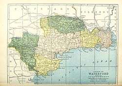 Barony map of County Waterford, 1900; Upperthird is coloured green, in the north. | |
| Sovereign state | Republic of Ireland |
| Province | Munster |
| County | Waterford |
| Area | |
| • Total | 258.38 km2 (99.76 sq mi) |
Etymology
Upperthird was originally called Uachtar Tíre, "upper country", referring to its high altitude (by Irish standards). Tír became "third" presumably by analogy with Middle Third; "third" is commonly used to indicate Irish divisions of land, without any region being actually divided in three.
Geography
Upperthird is located in the Waterford uplands to the south of the River Suir and north of the River Nier, containing most of the Comeragh Mountains and the Clodiagh River valley. It also contains two large lakes, Coumshingaun Lough and Crotty's Lake.[3][4]
History
This part of the Suir valley was the traditional territory of the O'Flanagan of Upperthird (Ó Flannagáin Uachtar Tíre). It contains Mothel Abbey, an ecclesiastical centre from the 6th to 16th centuries AD.
Abraham Ortelius's map of 1602 shows the land belonging to the Aylward family (an Anglo-Norman surname, in Irish Aighleart).[6][7]
The barony was seized in the post-Cromwellian confiscations (1652) and formed part of the Down Survey (1655–56).[8] It was granted to the La Poer family, later known as "Power."[9] The region (together with parts of Middle Third) was known as "Powers' Country."[10]
Upperthird was traditionally productive farmland. The region is famous as the home of Kilmeadan cheddar cheese.[11]
List of settlements
Below is a list of settlements in Upperthird barony:
- Carrickbeg (formerly part of County Waterford, now moved to County Tipperary as part of Carrick-on-Suir)
- Portlaw
- Rathgormack
References
- O'Laughlin, Michael C. (19 December 1994). "The Master Book of Irish Placenames: Placename Locator and Master Atlas of Ireland". Irish Roots Cafe – via Google Books.
- "Uachtar Tíre/Upperthird". Logainm.ie.
- "Uachtar Tíre/Upperthird". Logainm.ie.
- "Waterford City & County Council : DECIES - No.47". www.waterfordcouncil.ie.
- Smith, Charles (19 December 1774). The Ancient and Present State of the County and City of Waterford. W. Wilson. p. 74 – via Internet Archive.
upperthird.
- O'Laughlin, Michael C. (19 December 2018). "County Waterford, Ireland: Genealogy and Family History Notes". Irish Roots Cafe – via Google Books.
- "Sloinne". www.sloinne.ie.
- http://snap.waterfordcoco.ie/collections/ejournals/100769/100769_2.pdf
- "O'Flanagan of Upperthird – Ó Flannagáin Uachtar Tíre - Clans of Ireland". www.clansofireland.ie.
- Smith, Charles (19 December 1774). The Ancient and Present State of the County and City of Waterford. W. Wilson. p. 303 – via Internet Archive.
upper third waterford.
- Nolan, William; Power, Thomas P. (1 January 1992). "Waterford History & Society: Interdisciplinary Essays on the History of an Irish County". Geography – via Google Books.
| ||
| ||
Places in County Waterford | ||
|---|---|---|
| Towns |  | |
| Villages and Townlands |
| |
| ||