Decies-without-Drum
Decies-without-Drum (/ˈdeɪʃə/; Irish: Na Déise lasmuigh den Drom[1]) is a barony in County Waterford, Republic of Ireland.[2][3]
Decies-without-Drum Na Déise lasmuigh den Drom (Irish) | |
|---|---|
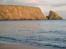 St John's Island at sunset, Ballydowane Bay | |
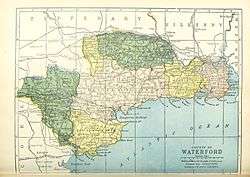 Barony map of County Waterford, 1900; Decies-without-Drum is coloured pink, in the centre. | |
| Sovereign state | Republic of Ireland |
| Province | Munster |
| County | Waterford |
| Area | |
| • Total | 525.66 km2 (202.96 sq mi) |
Etymology
Decies (Déisi Muman) north of the Drum Hills (Drom Fhinín). "Without" is used with the meaning of "beyond" or "outside."
Geography
Decies-without-Drum is located in the centre of County Waterford, including the coast between Dungarvin and Dunbrattin Head. It is divided from Decies-within-Drum by the Drum Hills.[4][5] It is mostly upland, and is bordered to the west by the Munster Blackwater, and contains most of the River Bricky and Colligan River.[6]
History
Déisi Muman were an ancient Gaelic Irish tribe that occupied this territory; their name means "Vassals of Mumu." and they are believed by some historians to have Gaulish origin.[7] Drumlohan Souterrain and Ogham Stones is an important historic site (AD 400–900).
The origin Decies barony was divided into two halves some time between 1654 and 1774.[6]
Various branches of the Power / La Poer family owned land in the region before the Cromwellian settlement.[8] Some of it also belonged to the Welsh/Walsh family.[9]
List of settlements
Below is a list of settlements in Decies-without-Drum barony:
References
- "Na Déise lasmuigh den Drom/Decies-without-Drum". Logainm.ie.
- "Traveller's New Guide Through Ireland, Containing a New and Accurate Description of the Roads". Longman. 21 December 2018 – via Google Books.
- Walsh, Thomas (21 December 2018). "History of the Irish Hierarchy, with the Monasteries of Each County, Biographical Notices of the Irish Saints, Prelates and Religious". Sadlier – via Google Books.
- "Maps of lands in the baronies of Decies-within-Drum, Decies-without-Drum-Gaultiere and Waterford Co. Borough, Co. Waterford by John Brownrigg and John Longfield. 1792 - 1834". sources.nli.ie.
- "Decies Without Drum IrlBarony through time - Census tables with data for the Barony". www.visionofireland.org.
- "The Parliamentary Gazetteer of Ireland: Adapted to the New Poor-law, Franchise, Municipal and Ecclesiastical Arrangements, and Compiled with a Special Reference to the Lines of Railroad and Canal Communication as Existing in 1843-44; Illustrated by a Series of Maps, and Other Plates; and Presenting the Results, in Detail, of the Census of 1841, Compared with that of 1831". A. Fullarton. 21 December 2018 – via Google Books.
- "The Decies - Early Waterford History - Waterford County Museum". www.waterfordmuseum.ie.
- "Estate Record: Power (Decies-without-Drum)". landedestates.nuigalway.ie.
- http://www.landedestates.ie:8080/LandedEstates/jsp/estate-show.jsp?id=3458
| ||
| ||
Places in County Waterford | ||
|---|---|---|
| Towns | 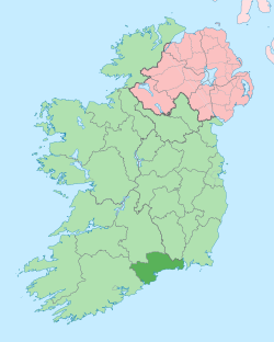 | |
| Villages and Townlands |
| |
| ||