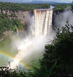
Potaro-Siparuni
Potaro-Siparuni (Region 8) is a region of Esequiban Guyana, a territory in dispute by Guyana and Venezuela. Venezuela claims the territory as part of Bolívar state. Unlike a south section of the region who is located east of Essequibo river, which means is out of the dispute.
Potaro-Siparuni Region 8 | |
|---|---|
Administrative Region | |
 | |
 Flag | |
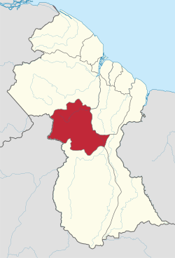 Map of Guyana showing Potaro-Siparuni region | |
| Country | |
| Regional Capital | Mahdia |
| Area | |
| • Total | 20,051 km2 (7,742 sq mi) |
| Population (2012 census) | |
| • Total | 10,190 |
| • Density | 0.51/km2 (1.3/sq mi) |
| [2] | |
It borders the region of Cuyuni-Mazaruni to the north, the regions of Upper Demerara-Berbice and East Berbice-Corentyne to the east, the region of Upper Takutu-Upper Essequibo to the south and Brazil to the west.
The main towns in the region are Kangaruma, Orinduik, Potaro Landing, Mahdia, Saveretik and Tumatumari.
Population
The Government of Guyana has administered three official censuses since the 1980 administrative reforms, in 1980, 1991 and 2002.[3] In 2012, the population of Potaro-Siparuni was recorded at 10,190 people.[4] Official census records for the population of Potaro-Siparuni are as follows:

- 2012 : 10,190
- 2002 : 10,095
- 1991 : 5,616
- 1980 : 4,485
Communities
(including name variants):
- Arnik Village
- Campbelltown
- Chenapou (Chenapowu Village)
- El Paso
- Enaruko Village
- Holmia
- Ipichau (Ipishau, Ipisháu, Ipisiau Village)
- Itabac
- Kamana Village
- Kanapang Village
- Kangaruma
- Karisparu Village
- Kato (Kato Village, Karto)
- Kopinang Mission
- Kukuieng (Kukui-Eng Village)
- Kurikebaru (Kurikebary, Kurukabaru, Kurukabaru Village)
- Mahdia
- Maicobi
- Maipuri Landing
- Makari
- Monkey Mountain
- Orinduik
- Owenteik
- Paramakatoi (Paramahatoi)
- Potaro Landing
- Princeville
- Puwa (Puwa Village)
- Saint Mary (Saint Mary's)
- Saveretik
- Sisipelin (Sisipelin Village)
- Taruka
- Tumatumari
- Tumatumari Landing
- Velgrad
- Waipa Village
- Wandaik (Wandaik Village)
- Wandapa (Wandapa Village, Waudapa Village)
- Wiapri
See also
References
- "Official Announcements". Archived from the original on 8 September 2016. Retrieved 28 July 2016.
- Macmillan Publishers (2009). "Administrative Regions - 8, 9 and 10". Macmillan Junior Atlas: Guyana. Oxford: Macmillan Caribbean. p. 37. ISBN 9780333934173.
- Beaie, Sonkarley Tiatun (19 September 2007). "Chapter 3: National Redistribution and Internal Migration" (PDF). 2002 Population and Housing Census - Guyana National Report. Bureau of Statistics. p. 51. Archived from the original (PDF) on 24 November 2007. Retrieved 29 August 2012.
- Beaie, Sonkarley Tiatun (19 September 2007). "National Population Trends: Size, Growth and Distribution" (PDF Download). 2002 Population and Housing Census - Guyana National Report. Bureau of Statistics. p. 25. Retrieved 29 August 2012.