University of California Natural Reserve System
The University of California Natural Reserve System (UCNRS) is a system of protected areas throughout California.[1]
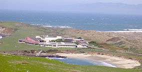
Bodega Marine Lab, Bodega Marine Reserve
List of reserves
| Reserve | Campus | Area (ha) | Area (Acre) | Coordinates | Web | Notes | |
|---|---|---|---|---|---|---|---|
| Angelo Coast Range Reserve | Berkeley | 3,166 | 7,915 | 39°43′45″N 123°38′40″W | [2] | On the South Fork of the Eel River. Protected by The Nature Conservancy (TNC). | |
| Año Nuevo Island Reserve | Santa Cruz | 10 | 25 | 37°6′30″N 122°20′10″W | [3] | On Año Nuevo Island. UC manages site within the larger Año Nuevo State Reserve, owned and operated by California State Parks. | |
| Blue Oak Ranch Reserve | Berkeley | 1,319 | 3,260 | 37°22′53″N 121°44′14″W | [4] | In the Diablo Range, northwest of Mount Hamilton. | |
| Bodega Marine Reserve | Davis | 176 | 436 | 38°18′25″N 123°3′54″W | [5] | On Bodega Bay. | |
| Box Springs Reserve | Riverside | 65 | 160 | 33°59′31″N 117°17′43″W | [6] | Adjacent to the Riverside campus. | |
| Philip L. Boyd Deep Canyon Desert Research Center | Riverside | 6,749 | 16,873 | 33°35′N 116°20′W | [7] | In the Santa Rosa Mountains, near Palm Desert. | |
| Burns Piñon Ridge Reserve | Irvine | 124 | 306 | 34°8′20″N 116°27′10″W | [8] | In the Mojave Desert, near Joshua Tree National Park. | |
| Carpinteria Salt Marsh Reserve | Santa Barbara | 93 | 230 | 34°24′N 119°31′W | [9] | In Carpinteria. | |
| Chickering American River Reserve | Berkeley | 695 | 1,720 | 39°14′48″N 120°19′31″W | [10] | In the headwaters basin of the North Fork of the American River, Sierra Nevada. | |
| Coal Oil Point Natural Reserve | Santa Barbara | 68 | 170 | 34°25′N 119°52′W | [11] | Adjacent to the Santa Barbara campus. | |
| Dawson Los Monos Canyon Reserve | San Diego | 93 | 230 | 33°8′30″N 117°15′20″W | [12] | In the northwestern Laguna Mountains. | |
| Elliott Chaparral Reserve | San Diego | 43 | 107 | 32°52′6″N 117°8′33″W | [13] | At former Camp Kearny, on the Kearny Mesa. | |
| Emerson Oaks Reserve | Riverside | 102 | 255 | 33°28′N 117°2′W | [14] | In the Temecula Valley, southern Riverside County. Protected by TNC. | |
| Fort Ord Natural Reserve | Santa Cruz | 242 | 606 | 36°40′N 121°46′W | [15] | At the former Fort Ord, near Monterey Bay. | |
| Hastings Natural History Reservation | Berkeley | 932 | 2,392 | 36°12′30″N 121°33′30″W | [16] | In the Santa Lucia Mountains, upper Carmel Valley. | |
| James San Jacinto Mountains Reserve | Riverside | 12 | 29 | 33°48′30″N 116°46′40″W | [17] | In the San Jacinto Mountains. Satellite site Oasis de los Osos (west end of the Coachella Valley) protected by TNC. | |
| Jenny Pygmy Forest Reserve | Berkeley | 28 | 70 | 39°17′N 123°45′W | [18] | Above the coast in Mendocino County. Protected by TNC. | |
| Jepson Prairie Reserve | Davis | 634 | 1,566 | 38°16′N 121°49′W | [19] | In the Central Valley. Protected by TNC and the Solano Land Trust. | |
| Kendall-Frost Mission Bay Marsh Reserve | San Diego | 7 | 16 | 32°47′N 117°13′W | [20] | On Mission Bay. | |
| Kenneth S. Norris Rancho Marino Reserve | Santa Barbara | 200 | 500 | 35°31′41″N 121°4′35″W | [21] | In the Santa Lucia Mountains, near Cambria. | |
| Landels-Hill Big Creek Reserve | Santa Cruz | 1,584 | 3,911 | 36°4′N 121°35′W | [22] | In the Santa Lucia Mountains, along the Big Sur coast. TNC involved in the protection of this site. | |
| McLaughlin Natural Reserve | Davis | 2,800 | 7,050 | 38°52′N 122°24′W | [23] | Within the Blue Ridge Berryessa Natural Area. | |
| Motte Rimrock Reserve | Riverside | 289 | 715 | 33°48′45″N 117°15′30″W | [24] | In western Perris Valley, Peninsular Ranges. | |
| Quail Ridge Reserve | Davis | 784 | 1,937 | 38°28′59″N 122°8′58″W | [25] | Near the Blue Ridge Berryessa Natural Area. QuRiNet deployed here. | |
| Sagehen Creek Field Station | Berkeley | 183 | 452 | 39°25′57″N 120°14′13″W | [26] | In the Northern Sierra Nevada, north of Lake Tahoe. Operated by the University of California under a long-term special-use permit from the U.S. Forest Service. | |
| San Joaquin Marsh Reserve | Irvine | 82 | 202 | 33°39′30″N 117°51′30″W | [27] | Upper Newport Bay. | |
| Santa Cruz Island Reserve | Santa Barbara | 18,624 | 46,020 | 34°0′N 119°44′W | [28] | Santa Cruz Island. Protected, owned, and managed by TNC. | |
| Scripps Coastal Reserve | San Diego | 342 | 844 | 32°52′30″N 117°15′15″W | [29] | Adjacent to the UC San Diego Scripps Institution of Oceanography. | |
| Sedgwick Reserve | Santa Barbara | 2,358 | 5,896 | 34°42′N 120°1′W | [30] | In the Santa Ynez Valley and the foothills of the San Rafael Mountains. | |
| Sierra Nevada Research Station—Yosemite Field Station | Merced | 37°32′23″N 119°39′29″W | [31] | Yosemite National Park, Sierra Nevada. | |||
| Stebbins Cold Canyon Reserve | Davis | 233 | 583 | 38°30′32″N 122°5′50″W | [32] | Within the Blue Ridge Berryessa Natural Area. | |
| Steele Burnand Anza-Borrego Desert Research Center | Irvine | 248,882 | 615,000 | 33°14′N 116°23′W | [33] | An agreement with Anza-Borrego Desert State Park and the Anza-Borrego Foundation makes the park, which is managed by California State Parks, available to field station users. | |
| Stunt Ranch Santa Monica Mountains Reserve | Los Angeles | 126 | 310 | 34°6′N 118°39′W | [34] | In Los Angeles County, within the Santa Monica Mountains National Recreation Area. | |
| Sweeney Granite Mountains Desert Research Center | Riverside | 3,600 | 9,000 | 34°48′20″N 115°39′50″W | [35] | In the Granite Mountains, within the Mojave National Preserve. | |
| Valentine Eastern Sierra Reserve | Santa Barbara | 87 | 205 | 37°37′30″N 118°59′30″W | [36] | In the high Sierra Nevada and the upper Owens Valley. Includes Valentine Camp and the Sierra Nevada Aquatic Research Laboratory (SNARL). | |
| White Mountain Research Center | Los Angeles | 18 | 45 | 37°21′41″N 118°19′36″W | [37] | Five research facilities ranging from the Owens Valley to the highest point of the White-Inyo Mountains east of the town of Bishop. | |
| Younger Lagoon Reserve | Santa Cruz | 10 | 26 | 36°57′3″N 122°3′57″W | [38] | The northwest edge of Monterey Bay on the west side of the city of Santa Cruz. |
References
- "University of California Natural Reserve System—UCNRS". The Regents of the University of California. Retrieved 8 April 2013.
- Angelo Coast Range Reserve
- Año Nuevo Island Reserve
- Blue Oak Ranch Reserve
- Bodega Marine Reserve
- Box Springs Reserve Archived 2009-10-22 at the Wayback Machine
- Philip L. Boyd Deep Canyon Desert Research Center
- Burns Piñon Ridge Reserve
- Carpinteria Salt Marsh Reserve
- Chickering American River Reserve Archived 2008-05-16 at the Wayback Machine
- Coal Oil Point Natural Reserve
- Dawson Los Monos Canyon Reserve
- Elliott Chaparral Reserve
- Emerson Oaks Reserve
- Fort Ord Natural Reserve
- Hastings Natural History Reservation
- James San Jacinto Mountains Reserve
- Jenny Pygmy Forest Reserve
- Jepson Prairie Reserve
- Kendall-Frost Mission Bay Marsh Reserve
- Kenneth S. Norris Rancho Marino Reserve
- Landels-Hill Big Creek Reserve
- McLaughlin Natural Reserve
- Motte Rimrock Reserve
- Quail Ridge Reserve
- Sagehen Creek Field Station
- San Joaquin Freshwater Marsh Reserve
- Santa Cruz Island Reserve
- Scripps Coastal Reserve
- Sedgwick Reserve
- Yosemite Field Station
- Stebbins Cold Canyon Reserve
- Steele Burnand Anza-Borrego Desert Research Center
- Stunt Ranch Santa Monica Mountains Reserve
- Sweeney Granite Mountains Desert Research Center
- Valentine Eastern Sierra Reserve
- White Mountain Research Center
- Younger Lagoon Reserve
- Harrison, S., Waddell, S. M. and Boucher, V. L. 2004. UC Davis Natural Reserve System-Four-Year Report (1999-2003) . UC Davis Natural Reserve System.
- Herring, Margaret. 2000. Studying Nature in Nature: The History of the University of California Natural Reserve System . Reprinted from Chronicle of the University of California, No. 3 (Spring 2000).
- University of California Office of the President (2007-07-30). "Natural Reserve System". Retrieved 2007-09-08.
External links
This article is issued from Wikipedia. The text is licensed under Creative Commons - Attribution - Sharealike. Additional terms may apply for the media files.