Tievebaun Mountain
Tievebaun Mountain, also known as Taobh Bán ("grassy slope") in Irish,[2] is a mountain located in County Leitrim. Its classifications include: "Arderin" & "Vandeleur-Lynam". The height of the mountain is 611 m (2,005 ft).[3] The mountain is most notable for its cliffs as well as the pinnacles which are located on the eastern and northern sides. The pinnacle known as Eagles Rock is actually the mountain's main summit.
| Tievebaun Mountain | |
|---|---|
| Taobh Bán | |
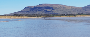 Tievebaun viewed from Mullaghmore | |
| Highest point | |
| Elevation | 611 m (2,005 ft) |
| Prominence | 106 m (348 ft) |
| Coordinates | 54°23′50″N 8°21′26″W [1] |
| Naming | |
| Language of name | Irish |
| Geography | |
 Location in Ireland | |
| Location | County Leitrim, Republic of Ireland |
| Parent range | Dartry Mountains |
Tievebaun Mountain is the third highest mountain in the Dartry Mountains range, and ranked as the 254th highest mountain in Ireland. Tievebaun Mountain is the highest independent peak in County Leitrim; however, the mountain's summit is only the second highest point in the county, as the southeast ridge of Truskmore Mountain lies within Leitrim, at 631 m (2,070 ft) above sea-level.
References
- http://mountainviews.ie/summit/253
- "Tievebaun Mountain (Taobh Ban) Hill Details + GPS Waypoint (#20210)". Haroldstreet.org.uk. Retrieved 2014-05-12.
- http://mountainviews.ie/summit/253/comment/2376