Thornton, Cape Town
Thornton is a southern suburb of Cape Town, South Africa. Thornton is situated only 10 kilometres (6 mi) east of the city centre, adjacent to Pinelands. Like Pinelands, Thornton is a mainly residential suburb with an abundance of trees. It is bordered by the Elsieskraal River, Pinelands, Viking Way, and the M7 Jakes Gerwel Drive. Many of the streets in Thornton are named after Viking themes, such as Thor Circle, Odin Drive and Viking Way. Others are named after trees, such as Poplar Avenue and Sipres Avenue.
Thornton Thorntonite | |
|---|---|
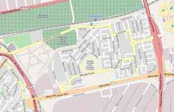 Street map of Thornton | |
 Thornton Street map of Thornton  Thornton Thornton (South Africa) | |
| Coordinates: 33°55′25″S 18°32′07″E | |
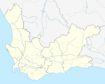
| Country | South Africa |
| Province | Western Cape |
| Municipality | City of Cape Town |
| Main Place | Pinelands |
| Government | |
| • Councillor | Brian Watkyns (DA) |
| Area | |
| • Total | 1.89 km2 (0.73 sq mi) |
| Population (2011)[1] | |
| • Total | 4,707 |
| • Density | 2,500/km2 (6,500/sq mi) |
| Racial makeup (2011) | |
| • Black African | 23.9% |
| • Coloured | 49.0% |
| • Indian/Asian | 3.7% |
| • White | 20.4% |
| • Other | 3.0% |
| First languages (2011) | |
| • English | 72.4% |
| • Afrikaans | 12.1% |
| • Xhosa | 8.0% |
| • Tswana | 1.1% |
| • Other | 6.5% |
| Time zone | UTC+2 (SAST) |
| Postal code (street) | 7460 |
| PO box | 7485 |
| Area code | 021 |
Demographics
According to the 2011 Census, Thornton has a population of 5,862 people,[2] with 94% of the labour force (aged 15 to 64) being employed. The predominant language spoken in Thornton is English.
Geography
Thornton, like Pinelands, is in the Southern Suburbs of Cape Town, sitting close to the border delineating the Northern and Southern Suburbs. There are many trees lining the roads of Thornton, and there are green spaces with wild flowers.
Education
The College of Cape Town has a Thornton Campus for Civil and Mechanical Engineering. There is also the Thornton Primary School.
Sports
The Santos Sports Fields are in Thornton. There are also children's play parks within Thornton.
Amenities
There are two shopping centres in Thornton, including two convenience stores and shops such as a locksmith, barber, pet shop and electronics store. There are also churches in Pinelands, including the N.G. Kerk Thornton.
References
- "Sub Place Thornton". Census 2011.
- "Thornton" (PDF). Census 2011. City of Cape Town. Retrieved 16 August 2016.
Communities of City of Cape Town Metropolitan Municipality, Western Cape | ||
|---|---|---|
Seat: Cape Town | ||
| Atlantic Seaboard | .svg.png) City of Cape Town within South Africa | |
| Blaauwberg | ||
| Cape Flats | ||
| City Centre | ||
| Helderberg | ||
| Northern Suburbs | ||
| Southern Suburbs | ||
| South Peninsula | ||