Thorndale, Pennsylvania
Thorndale is a census-designated place in Chester County, Pennsylvania, United States. The population was 3,407 at the 2010 census. Thorndale is the commercial and administrative center of Caln Township. The community's main street is U.S. Route 30 Business. Many of Thorndale's old houses fell into disrepair from the late 1990s to present and have been torn down and replaced with new businesses. Thorndale is historically notable for containing a summer house of US President James Buchanan, which still stands and has been incorporated into a golf course and turned into a restaurant. The community contains the Thorndale Fire Station and Caln Elementary School, part of the Coatesville Area School District. Thorndale sits along SEPTA's Paoli/Thorndale Line and is currently the last station stop on that line. It is also served by the Rover bus system.
Thorndale | |
|---|---|
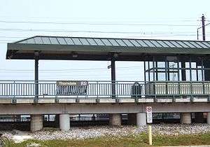 Thorndale SEPTA Station | |
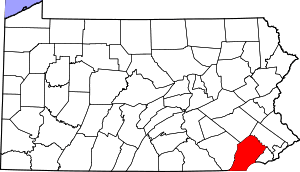
 Location in Chester County and the U.S. state of Pennsylvania. | |
| Coordinates: 39°59′47″N 75°45′06″W | |
| Country | United States |
| State | Pennsylvania |
| County | Chester |
| Township | Caln |
| Area | |
| • Total | 1.8 sq mi (5 km2) |
| • Land | 1.8 sq mi (5 km2) |
| • Water | 0.0 sq mi (0 km2) |
| Elevation | 344 ft (105 m) |
| Population (2010) | |
| • Total | 3,407 |
| • Density | 1,900/sq mi (730/km2) |
| Time zone | UTC-5 (EST) |
| • Summer (DST) | UTC-4 (EDT) |
| ZIP code | 19372 |
| Area code(s) | 610 and 484 |
Geography
Thorndale is located at 39°59′47″N 75°45′6″W (39.996456, -75.751606).[1]
According to the United States Census Bureau, the CDP has a total area of 1.8 square miles (4.7 km2), of which 0.55% is water. It is part of Caln Township, with students attending school in either the Coatesville Area School District or the Downingtown Area School District.
Demographics
At the 2000 census there were 3,561 people, 1,347 households, and 952 families in the CDP. The population density was 1,953.2 people per square mile (755.4/km²). There were 1,418 housing units at an average density of 777.8/sq mi (300.8/km²). The racial makeup of the CDP was 82.65% White, 10.98% African American, 0.22% Native American, 2.33% Asian, 0.11% Pacific Islander, 2.13% from other races, and 1.57% from two or more races. Hispanic or Latino of any race were 4.32%.[2]
There were 1,347 households, 36.8% had children under the age of 18 living with them, 57.2% were married couples living together, 9.3% had a female householder with no husband present, and 29.3% were non-families. 22.3% of households were made up of individuals, and 5.4% were one person aged 65 or older. The average household size was 2.63 and the average family size was 3.12.
The age distribution was 26.1% under the age of 18, 7.9% from 18 to 24, 36.1% from 25 to 44, 21.1% from 45 to 64, and 8.7% 65 or older. The median age was 35 years. For every 100 females, there were 94.8 males. For every 100 females age 18 and over, there were 95.2 males.
The median household income was $61,830 and the median family income was $70,781. Males had a median income of $45,573 versus $35,096 for females. The per capita income for the CDP was $25,376. About 4.4% of families and 6.4% of the population were below the poverty line, including 9.9% of those under age 18 and 14.5% of those age 65 or over.
References
| Wikivoyage has a travel guide for Thorndale. |
- "US Gazetteer files: 2010, 2000, and 1990". United States Census Bureau. 2011-02-12. Retrieved 2011-04-23.
- "U.S. Census website". United States Census Bureau. Retrieved 2008-01-31.
| Authority control |
|---|