The Equator monument
The Equator monument is located on the equator in Pontianak, Indonesia. It marks the division between the northern and southern hemispheres.
History
- First monument built in 1928 by a Dutch geographer.
- 1930 completed, in form of bollard radially and dart.
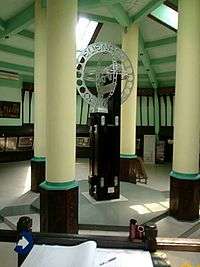
- 1938 rebuilt with completion by architect Silaban. The original monument is still visible in the interior.
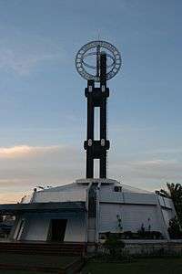
- 1990 renovated with the addition of a dome to protect the original monument and also making of duplicate of monument of the size five times bigger than its original size.
- Its grand opening on 1991 September 21.
Construction
The monument consists of four iron wood poles, each with a diameter of about 0,30 metre, with frontage bollard height is two pieces as high as 3,05 radian place backside bollard and the signpost dart as high as 4,40 metres.
Location
Its location is in Jalan Khatulistiwa literally translated into Equator Road, North Pontianak, about 3 kilometres from the city centre of Pontianak.
The equator monument is not on the equator any more. The equator has moved slightly southwards and there is another line outside the monument, that shows the recorded position in 2005. The position of the equator in 2010 is even further south and in the river, as a GPS device can confirm.