Texas State Highway 349
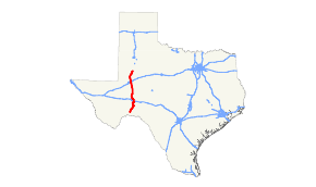
State Highway 349 or SH 349 is a 194.43-mile-long (312.90 km) state highway in the western part of Texas, United States.
| ||||
|---|---|---|---|---|
 | ||||
| Route information | ||||
| Maintained by TxDOT | ||||
| Length | 194.427 mi[1] (312.900 km) | |||
| Existed | 1943–present | |||
| Major junctions | ||||
| South end | ||||
| North end | ||||
| Location | ||||
| Counties | Terrell, Pecos, Crockett, Upton, Midland, Martin, Dawson | |||
| Highway system | ||||
| ||||

History
The original formation of the highway on August 3, 1943 included only the section from Rankin to Midland, replacing FM 9.[2] On April 30, 1947, FM 306 and FM 177 were redesignated to form the segment of SH 349 from Midland to near Lamesa. The section from Sheffield to Rankin was added on October 24, 1956 by redesignating part of SH 51.

The part of SH 349 south of Sheffield was Farm to Market Road 1217, which was designated on July 14, 1949 from Dryden northward 5 miles (8 km).[3] FM 1217 was extended to the northeast 3.2 miles (5.1 km) on May 23, 1951, 7.0 miles (11.3 km) on December 18, 1951, 14.0 miles (22.5 km) on December 17, 1952, and 2.3 miles (3.7 km) on April 24, 1954. The designation was extended 10.0 miles (16.1 km) on September 29, 1954 to the end of FM 1749, which was cancelled and combined with FM 1217, adding 17.8 miles (28.6 km) and bringing its southern terminus to Sheffield. On December 13, 1956, FM 1217 was signed, but not designated, as part of SH 349. In 1990, FM 1217 was officially designated as SH 349, and FM 1217 was cancelled. On July 31, 2003, SH 349 was rerouted around Midland.
In December 2014, the Texas Transportation Commission approved an extension of the SH 349 designation south of Lamesa, from the current northern terminus at SH 137 eastward to US 87. As of January 2015, this segment has not been constructed.[4] Construction of the extension started in May 2017 and was completed just over two years later in mid-2019.[5]
Route description
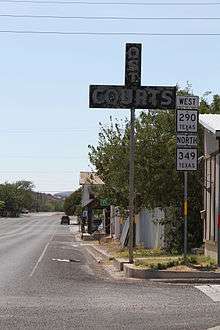
SH 349 runs generally northward from its originating junction with U.S. Highway 90 at the tiny town of Dryden (population 13) near the Rio Grande, the southern border of the state. The road passes west of the Fort Lancaster State Historical Park to Sheffield and a junction with Interstate 10. SH 349 then runs along the Pecos River to Iraan, where it is co-routed for a few miles with U.S. Highway 190. The road then proceeds northward to a junction and brief co-routing with U.S. Highway 67 at Rankin. SH 349 continues northward to the relatively heavily populated area of Midland.
SH 349 formerly bisected Midland directly through the city center. However, the highway has been redesignated to loop around Midland to the west, by co-routing it with portions of Interstate 20 (and State Highway 158) and Farm to Market Road 1788. A new section of highway, a so-called "reliever route", was opened on December 10, 2009, and was named the Nadine and Tom Craddick Highway after State Rep. Tom Craddick and his wife, who played a large role in creating the highway.[6] (This new section of SH 349 is part of the "La Entrada al Pacifico Corridor" trade route from west Texas to Mexico). The portion of SH 349 that ran directly through Midland was redesignated as Business State Highway 349-C (BS 349-C) in 2003.[7] North of Midland, SH 349 proceeds generally northward to its final junction with State Highway 137, just south of Lamesa. Counties traversed by the highway include Terrell, Pecos, Crockett, Upton, Midland, Martin and Dawson. With the exception of the metropolitan area of Midland, most of the terrain covered by the highway is sparsely populated ranch country.[8]
Business routes
| |
|---|---|
| Location | Martin and Midland counties |
| Length | 8.758 mi[9] (14.095 km) |
| Existed | 2003–present |
SH 349 has one business route.
Business State Highway 349-C is a business loop that runs on the former routing of SH 349 through Midland. The route was designated in 2003 when SH 349 was re-routed around the city.[9]
- Junction list
The entire route is in Midland.
| County | mi | km | Destinations | Notes | |
|---|---|---|---|---|---|
| Midland | 0.0 | 0.0 | I-20 exit 136 | ||
| 1.1 | 1.8 | Former Bus. SH 158 east | |||
| 1.7 | 2.7 | Wall Street | Former Bus. SH 158 west | ||
| 4.9 | 7.9 | Interchange | |||
| Martin | 8.8 | 14.2 | |||
| 1.000 mi = 1.609 km; 1.000 km = 0.621 mi | |||||
Junction list
| County | Location | mi | km | Destinations | Notes | |||
|---|---|---|---|---|---|---|---|---|
| Terrell | Dryden | 0.0 | 0.0 | Southern terminus | ||||
| | 29.5 | 47.5 | ||||||
| | 47.9 | 77.1 | ||||||
| Pecos | Sheffield | 58.9 | 94.8 | South end of SH 290 overlap | ||||
| | 63.6 | 102.4 | North end of SH 290 overlap; I-10 exit 325 | |||||
| Iraan | 76.9 | 123.8 | South end of US 190 overlap | |||||
| | 81.4 | 131.0 | North end of US 190 overlap | |||||
| Crockett |
No major junctions | |||||||
| Upton | | 99.7 | 160.5 | South end of US 67 overlap | ||||
| Rankin | 103.3 | 166.2 | ||||||
| 103.8 | 167.0 | North end of US 67 overlap | ||||||
| | 104.7 | 168.5 | ||||||
| | 110.7 | 178.2 | ||||||
| | 125.2 | 201.5 | ||||||
| Midland | | 137.4 | 221.1 | |||||
| | 138.4 | 222.7 | ||||||
| | 151.6 | 244.0 | ||||||
| Midland | 156.8 | 252.3 | South end of I-20 overlap; I-20 exit 136 | |||||
| see I-20 | ||||||||
| 166.2 | 267.5 | North end of I-20 overlap; South end of FM 1788 overlap; I-20 exit 125 | ||||||
| 167.0 | 268.8 | Interchange | ||||||
| 167.4 | 269.4 | |||||||
| 167.7 | 269.9 | |||||||
| | 170.8 | 274.9 | Interchange | |||||
| | 173.0 | 278.4 | North end of FM 1788 overlap | |||||
| | 174.6 | 281.0 | Interchange | |||||
| Martin | Midland | 185.5 | 298.5 | |||||
| | 201.5 | 324.3 | Interchange | |||||
| Dawson | Patricia | 220.2 | 354.4 | |||||
| | 220.5 | 354.9 | ||||||
| | 221.6 | 356.6 | ||||||
| | 226.8 | 365.0 | ||||||
| | 230.5 | 371.0 | South end of FM 2052 overlap | |||||
| | 230.6 | 371.1 | North end of FM 2052 overlap | |||||
| | 232.6 | 374.3 | Northern terminus | |||||
1.000 mi = 1.609 km; 1.000 km = 0.621 mi
| ||||||||
See also


References
- Transportation Planning and Programming Division (n.d.). "State Highway No. 349". Highway Designation Files. Texas Department of Transportation. Retrieved March 21, 2008.
- Transportation Planning and Programming Division (n.d.). "Farm to Market Road No. 9". Highway Designation Files. Texas Department of Transportation. Retrieved January 3, 2011.
- Transportation Planning and Programming Division (n.d.). "Farm to Market Road No. 1217". Highway Designation Files. Texas Department of Transportation. Retrieved July 30, 2010.
- "Minute Order 114180" (PDF). Texas Transportation Commission. December 18, 2014. Retrieved January 9, 2015.
- "State Highway 349 Extension Project Begins Monday, May 15 in Lamesa". KAMC. May 14, 2017. Retrieved November 30, 2019.
- https://twitter.com/TxDOTOdessa/statuses/6542677029
- Transportation Planning and Programming Division (n.d.). "Business State Highway No. 349-C". Highway Designation Files. Texas Department of Transportation. Retrieved July 3, 2017.
- Google (March 21, 2008). "overview map of SH 349" (Map). Google Maps. Google. Retrieved March 21, 2008.
- Transportation Planning and Programming Division (n.d.). "Business State Highway No. 349-C". Highway Designation Files. Texas Department of Transportation.
External links
![]()
- Texas official travel map at the Texas Department of Transportation (enlargement required for legibility)
- Construction notice for new portion of SH 349 to complete loop to the western side of Midland