Tábor
Tábor (Czech pronunciation: [ˈtaːbor]; German: Tabor) is a town in the South Bohemian Region of the Czech Republic, 100 kilometres (62 miles) south of the capital Prague. It lies on the river Lužnice. The town's name translates to "camp" or "encampment" in Czech.[2] The town gave its name to the Taborites, a radical wing of the Hussites.
Tábor | |
|---|---|
Town | |
 Aerial view of the old town | |
 Flag  Coat of arms | |
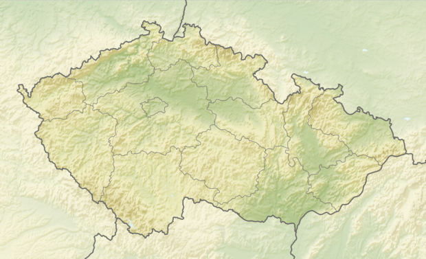 Tábor Location in the Czech Republic | |
| Coordinates: 49°24′52″N 14°39′28″E | |
| Country | |
| Region | South Bohemian |
| District | Tábor |
| Founded | 1420 |
| Government | |
| • Mayor | Štěpán Pavlík |
| Area | |
| • Total | 62.22 km2 (24.02 sq mi) |
| Elevation | 437 m (1,434 ft) |
| Population (2020-01-01[1]) | |
| • Total | 34,277 |
| • Density | 550/km2 (1,400/sq mi) |
| Time zone | UTC+1 (CET) |
| • Summer (DST) | UTC+2 (CEST) |
| Postal code | 390 01 |
| Website | http://www.taborcz.eu/ |
History
The town was founded in the spring of 1420 by Petr Hromádka of Jistebnice and Jan Bydlínský of Bydlín from the most radical wing of the Hussites, who soon became known as the Taborites. In the following years the town flourished as an egalitarian peasant commune. This spirit is celebrated in Smetana's "Song of Freedom", made famous in the English-speaking world by Paul Robeson's recording in Czech and English.
The historical part of the town is situated on the summit of an isolated hill separated from the surrounding country by the Lužnice river and by an extensive lake, to which the Hussites gave the biblical name of Jordan. This lake, founded 1492, is the oldest reservoir of its kind in Central Europe. The historical importance of the city of Tábor ceased only when it was captured by King George of Poděbrady in 1452.
Until 1918, the post town "Tabor – Tábor" was part of the Austrian monarchy (the Austrian side after the compromise of 1867), in the district with the same name, one of the 94 Bezirkshauptmannschaften in Bohemia.[3]
A post office was opened in the railway station in 1895.
Geography
The town is 437 m above sea level, the highest point is the Hýlačka observation tower and the lowest is the surface of the river. The area of the town is 62.22 km². The historical old town is situated on a hill above the river, which was used for the protection of the city. In the middle of the city lies the Jordán reservoir, which was created in 1492. It was originally used for storage of water, but nowadays it is mainly used for recreation. It is the oldest reservoir in Central Europe.[4]
Geology
Tábor is located in the geomorphological area called the Tábor Uplands. On the east edge of the town, there is a rock formation called "Granátová skála". The rock is a deposit of red garnets that can be as large as hazelnuts. The majority of the rock was mined and used as construction material. There is also geological exposition along the river called "Geologická expozice Pod Klokoty".
Sights
Though a large part of the ancient fortifications has been demolished, Tábor (or Hradiště Hory Tábor, the castle of the Tábor Hill, as it was called in the Hussite period) still preserves many memorials of its past fame. In the centre of the city is Žižka Square. Only very narrow streets lead to it; this rendered the approach to the square more difficult in times of war. Under the houses and streets is a labyrinth of tunnels. The townspeople dug cellars under their houses and these were subsequently interconnected; an approximately 500 m-long section of the tunnel system is open to the public and is a part of the Hussite museum.[5]
In the centre of the square there is a statue of Jan Žižka, the greatest of the Hussite leaders, the Dean Church of the Lord's Conversion on Mount Tabor, built in 1516 in the style of the Bohemian Renaissance, and the town hall, in connection with which a museum has been founded, which contains interesting relics of the Hussite period, such as the Altar Wings of Roudníky and farm carts which doubled as battle wagons. Major parts of the ancient fortifications and the ancient Kotnov tower and gate of Bechyně near the tower still exist.
Other sights:
- The first electric railway in Austria-Hungary which led from Tábor to Bechyně
- Měšice Castle – former Renaissance fortress, later rebuilt in Baroque style
- Church of the Assumption of the Virgin Mary – 600-year-old Roman Catholic church
- Chapel of St. Anna
- Tábor Zoo
Parks and nature
Park Pod Kotnovem
This park is placed next to Bechyňská gate and Kotnov tower – near the Old Town. Originally, it was an old cemetery but in the 19th century, it was converted into a park. Some of the gravestones remained here until present.
Husův park
The park started to form in 1871, after the train station was built. It was not reconstructed until 1991, along with some other buildings in the surroundings. The ceremonial opening of the newly reconstructed park was in 1997. At one part of this park, there stands a big monument (headstone) called "Mistr Jan Hus" by Czech sculptor František Bílek. It was built in 1928. The headstone is built from a granite base with a bronze statue of Jan Hus on it (3 meters tall), and a bronze relief board with Hus's life events and also an imitation of Kozí Hrádek (the place where Hus preached). On the other side of the park, nearer to the train station, there is a fountain called Girl with a jug, made in 1920.
Park U Popraviště
This park is the biggest park in Tábor. As the name suggests, the park is built around a former gallows, which was used during World War II. In 1942, 156 patriots were executed by the nationalists. For these victims, a monument was built (in 1945–1950), which includes a bronze board with lions and bronze relief board with figures. The rest of the park rose at the end of 20th century. It contains sculptures, fountains, tree alleys, benches, flower patches and a playground.
Botanical garden
This botanical garden was founded in 1866, which makes it the second oldest in the Czech Republic. After its establishment, it was much bigger – about 3600 m2. It belongs to the secondary school of agriculture, which is in front of it. It contains more than 4,000 different flowers and plants. The seeds from there are sent to more than 400 places in the world. Most of the garden is occupied by an arboretum. There is a small lake and a rock garden. The three glasshouses contains cacti, succulents, orchids, carnivorous plants and many other exotic plants. The entrance is for free, only the glasshouses are paid. During the year, special exhibitions of plants are organized.
Holečkovy sady
This park was founded in the 1930s. This green ring around the historic core of Tábor is named after a famous writer and translator Josef Holeček. The look of the park is atypical. It is on a hill and it has many paths and stairs made from rocks, lined with large trees. Some smaller monuments are also there – a memorial to Josef Holeček, a white gazebo, cross and two small chapels.
Transport
Tábor is a significant transport hub. It lies on the mainline railway linking Prague with České Budějovice and Linz and local branch lines to Bechyně and Pelhřimov. The town also lies on the European route E55 and it will be connected with Prague, České Budějovice and the Czech–Austrian border with a highway after the building of the planned D3 motorway is finished.
Sports
After the 2018–19 season, the local football club FC MAS Táborsko was relegated into the third-level Bohemian Football League.
Tábor is also equipped with a winter stadium. The local ice hockey club, HC Tábor, plays in the third-level ice hockey league.
Other sport facilities in Tábor include a swimming pool and the Komora sports complex.
Notable people
- Johan Peter Wotapek von Ritterwald (1676–1763), judge
- Jiří Balík (born 1953), agroscientist
- Helena Fuchsová (born 1965), 400m track and field athlete
- Joseph Gelinek (1758–1825), Catholic theologian, musician and composer
- Jakub Navrátil (born 1984), footballer
- Oskar Nedbal (1874–1930), violinist, composer and conductor
- Jana Sedláčková (born 1993), footballer
- Jan Šimák (born 1978), footballer
- Jiří Traxler (1912–2011), Czech-Canadian jazz pianist and composer
International relations
Twin towns – sister cities


Tábor is also part of the Commonwealth of towns with hussite past and tradition, along with other 11 Czech and 6 German municipalities.[7]
Administrative parts
- Čekanice
- Čelkovice
- Hlinice
- Horky
- Klokoty
- Měšice
- Náchod
- Smyslov
- Stoklasná Lhota
- Tábor
- Větrovy
- Všechov
- Zahrádka
- Záluží
- Zárybničná Lhota
Gallery
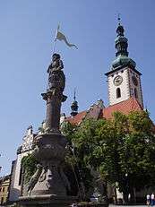 Church and statue of Roland
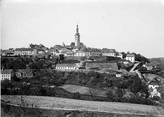 View of Tábor from the north, end of the 19th century, with well-visible city fortification, Ignác Šechtl
 Square of Jan Žižka with city hall and church, 1895, Ignác Šechtl
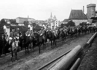 Kotnov tower with Sokol parade, 1902, Šechtl and Voseček
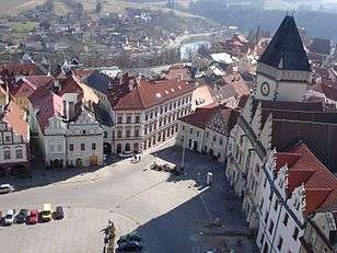 Southwest corner of Žižka Square as viewed from the church tower
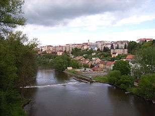 View of Tábor from the river Lužnice
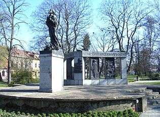 Monument to Jan Hus by sculptor František Bílek (made in 1928)
 Cloister Klokoty
 Old Town, Šechtl and Voseček
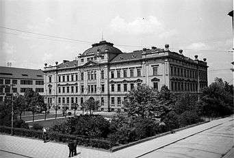 School of Agriculture, approx. 1935, Josef Jindřich Šechtl
References
| Wikisource has several original texts related to: Tábor |
- "Population of Municipalities – 1 January 2020". Czech Statistical Office. 30 April 2020.
- Profous, Antonín (1957). Místní jména v Čechách: Jejich vznik, původní význam a změny; part 4, S-Ž. Prague, Czechoslovakia: Czechoslovak Academy of Sciences.
- Die postalischen Abstempelungen auf den österreichischen Postwertzeichen-Ausgaben 1867, 1883 und 1890, Wilhelm KLEIN, 1967
- "The Lake Jordán". visittabor.eu. Retrieved 5 June 2019.
- "Underground Tunnels". visittabor.eu. Retrieved 5 June 2019.
- "Partnerská města" (in Czech). Město Tábor. Retrieved 27 June 2020.
- http://www.husitskamesta.net/mesta.html
- Augusta, Pavel / Klínková, Hana: TÁBOR, ISBN 80-86098-18-4 (Tábor 2001).
External links
| Wikimedia Commons has media related to Tábor. |
| Wikivoyage has a travel guide for Tábor. |
- Official website
- Historical photographs of the town
- the Hussite Museum in Tabor
- A website for tourists
- Timetables of local transport in Tabor
| Authority control |
|
|---|