Ratibořské Hory
Ratibořské Hory (German: Bergstädtel) is a village and municipality (obec) in Tábor District in the South Bohemian Region of the Czech Republic.
Ratibořské Hory | |
|---|---|
Municipality | |
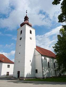 Saint Adalbert Church | |
 Ratibořské Hory | |
| Coordinates: 49°27′45″N 14°46′12″E | |
| Country | |
| Region | South Bohemian |
| District | Tábor |
| Area | |
| • Total | 21.13 km2 (8.16 sq mi) |
| Elevation | 418 m (1,371 ft) |
| Population (2006) | |
| • Total | 747 |
| • Density | 35/km2 (92/sq mi) |
| Postal code | 391 42 to 391 43 |
The municipality covers an area of 21.13 square kilometres (8.16 sq mi), and has a population of 747 (as at 2 October 2006).
Ratibořské Hory lies approximately 10 kilometres (6 mi) north-east of Tábor, 59 km (37 mi) north of České Budějovice, and 74 km (46 mi) south of Prague.
History
The municipality was founded in 1527 and further developed during the 16th century because of growing mining activities - the silver ores were found around the village Ratibořice and mineworkers were coming from Krušné hory area. After the thirty years war a new rise in silver mining occurred after 1737 under lordship of the Schwarzenbergs and at the end of the 18th century the population reached its peak of over 1000.