Sveagruva
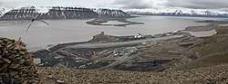
Sveagruva (meaning Swedish Mine), or simply Svea, is a mining settlement in the Norwegian archipelago of Svalbard, lying at the head of Van Mijenfjord. It is the third largest settlement in the archipelago (after Longyearbyen and Barentsburg). Currently, around 300 workers living in Longyearbyen commute to Sveagruva for work on a daily or weekly basis. Sveagruva has no permanent inhabitants. The mine was operated by Store Norske Spitsbergen Kulkompani. There is no road to Longyearbyen or other settlement, so travel is done through air from Svea Airport and coal transport by ship from a port 5 kilometres (3.1 mi) southwest.
Sveagruva | |
|---|---|
 | |
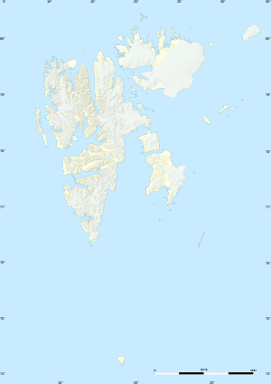 Sveagruva Location of Sveagruva and Svalbard | |
| Coordinates: 77°54′00″N 16°43′50″E | |
| Country | |
| Region | Svalbard |
| Founded | 1917 |
| Population (2007) | |
| • Total | 300 (commuting) |
History
The town was established in 1917 by Swedes.[1] It was thereafter destroyed in 1944, but quickly re-established after World War II. The mining activity ceased in 1949, and was not re-established until 1970. Mining was suspended for a short period in 1987. In the 1990s, the town nearly vanished, as mines in Longyearbyen proved more productive and accessible. In 2005, a mine fire erupted, lasting uninterrupted for more than five weeks, and causing 700 million Norwegian kroner worth of damage.
Sveagruva holds the most productive coal mine of Svalbard, the Svea Nord longwall mine. Opened in 2001, the mine produces up to 4 million metric tons of coal annually,[2] making it one of the largest underground coal mines in Europe.
Sveagruva closed in 2017 due to economic conditions.[3]
Weather and Climate
| Climate data for Sveagruva | |||||||||||||
|---|---|---|---|---|---|---|---|---|---|---|---|---|---|
| Month | Jan | Feb | Mar | Apr | May | Jun | Jul | Aug | Sep | Oct | Nov | Dec | Year |
| Average high °C (°F) | −13 (9) |
−13 (9) |
−13 (9) |
−9 (16) |
−3 (27) |
3 (37) |
7 (45) |
6 (43) |
2 (36) |
−4 (25) |
−8 (18) |
−11 (12) |
−3 (27) |
| Daily mean °C (°F) | −16.5 (2.3) |
−17 (1) |
−16.5 (2.3) |
−12.5 (9.5) |
−5 (23) |
1 (34) |
5 (41) |
4 (39) |
−0.5 (31.1) |
−6.5 (20.3) |
−11 (12) |
−14.5 (5.9) |
−6 (21) |
| Average low °C (°F) | −20 (−4) |
−21 (−6) |
−20 (−4) |
−16 (3) |
−7 (19) |
−1 (30) |
3 (37) |
2 (36) |
−3 (27) |
−9 (16) |
−14 (7) |
−18 (0) |
−9.5 (14.9) |
| Average precipitation mm (inches) | 22 (0.9) |
28 (1.1) |
29 (1.1) |
16 (0.6) |
13 (0.5) |
18 (0.7) |
24 (0.9) |
30 (1.2) |
25 (1.0) |
19 (0.7) |
22 (0.9) |
25 (1.0) |
271 (10.7) |
| Source: Sveagruva Climate Guide[4] | |||||||||||||
References
- "Svea Nord". Archived from the original on 2012-03-15.
- "Important dates in Store Norske's history". Archived from the original on 2016-01-29.
- Stange, Rolf (2019-02-15). "Lunckefjellet: the end of an arctic coal mine". Spitsbergen | Svalbard. Retrieved 2020-01-28.
- "Sveagruva Climate Guide, Svalbard". Weather2Travel.
Historic mines and processing operations of Norway | ||
|---|---|---|
|  | |