Suzu, Ishikawa
Suzu (珠洲市, Suzu-shi) is a city located in Ishikawa Prefecture, Japan. As of 31 January 2018, the city had an estimated population of 14,716 in 6231 households, and a population density of 60.0 persons per km², in 29,304 households.[1] The total area of the city was 247.20 square kilometres (95.44 sq mi).
Suzu 珠洲市 | |
|---|---|
 Suzu City Hall | |
 Flag  Seal | |
 Location of Suzu in Ishikawa Prefecture | |
 Suzu | |
| Coordinates: 37°26′10.8″N 137°15′37.7″E | |
| Country | Japan |
| Region | Chūbu (Hokuriku) |
| Prefecture | Ishikawa Prefecture |
| Government | |
| • - Mayor | Izumiya Masuhiro |
| Area | |
| • Total | 247.20 km2 (95.44 sq mi) |
| Population (January 31, 2018) | |
| • Total | 14,716 |
| • Density | 60/km2 (150/sq mi) |
| Time zone | UTC+9 (Japan Standard Time) |
| City symbols | |
| -Tree | Japanese red pine |
| -Flower | Camellia |
| -Bird | Japanese bush-warbler |
| Phone number | 0768-82-2222 |
| Address | 1-6-2, Uedomachi Kitagata, Suzu-shi, Ishikawa-ken 927–1295 |
| Website | www |
Etymology
Suzu is thought to have been named after Suzu Shrine, an ancient Shinto shrine located in the Awazu area of the city. The name "Suzu" appears in Nara period records; however, the kanji for Suzu (珠洲) is not thought to have been in use until the early Wadō era (713 AD). There is also the theory that the name originates from the Ainu language, as with several other place names in the Noto area.
Geography
Suzu occupies the northeastern tip of the Noto Peninsula and is bordered by the Sea of Japan on three sides. Parts of the city are within the borders of the Noto Hantō Quasi-National Park.
Demographics
Per Japanese census data,[2] the population of Suzu has declined over the past 40 years.
| Census Year | Population |
|---|---|
| 1970 | 29,224 |
| 1980 | 27,351 |
| 1990 | 23,471 |
| 2000 | 19,852 |
| 2010 | 16,300 |
Climate
Suzu has a humid subtropical climate (Köppen Cfa) characterized by mild summers and cold winters with heavy snowfall. The average annual temperature in Suzu is 13.0 °C. The average annual rainfall is 2234 mm with September as the wettest month. The temperatures are highest on average in August, at around 25.4 °C, and lowest in January, at around 2.4 °C.[3]
| Climate data for Suzu (1981–2010) | |||||||||||||
|---|---|---|---|---|---|---|---|---|---|---|---|---|---|
| Month | Jan | Feb | Mar | Apr | May | Jun | Jul | Aug | Sep | Oct | Nov | Dec | Year |
| Average high °C (°F) | 5.7 (42.3) |
6.1 (43.0) |
9.6 (49.3) |
15.7 (60.3) |
20.5 (68.9) |
23.8 (74.8) |
27.7 (81.9) |
29.8 (85.6) |
25.7 (78.3) |
20.4 (68.7) |
14.6 (58.3) |
9.1 (48.4) |
17.4 (63.3) |
| Daily mean °C (°F) | 2.5 (36.5) |
2.4 (36.3) |
5.0 (41.0) |
10.3 (50.5) |
15.2 (59.4) |
19.3 (66.7) |
23.5 (74.3) |
25.2 (77.4) |
21.1 (70.0) |
15.3 (59.5) |
9.9 (49.8) |
5.3 (41.5) |
12.9 (55.2) |
| Average low °C (°F) | −0.8 (30.6) |
−1.2 (29.8) |
0.4 (32.7) |
4.7 (40.5) |
10.1 (50.2) |
15.3 (59.5) |
19.9 (67.8) |
21.2 (70.2) |
17.1 (62.8) |
10.6 (51.1) |
5.3 (41.5) |
1.6 (34.9) |
8.7 (47.7) |
| Average precipitation mm (inches) | 229.7 (9.04) |
149.6 (5.89) |
130.0 (5.12) |
103.9 (4.09) |
112.4 (4.43) |
151.7 (5.97) |
186.2 (7.33) |
144.9 (5.70) |
203.5 (8.01) |
146.4 (5.76) |
213.4 (8.40) |
256.9 (10.11) |
2,028.6 (79.85) |
| Average snowfall cm (inches) | 110 (43) |
92 (36) |
25 (9.8) |
1 (0.4) |
0 (0) |
0 (0) |
0 (0) |
0 (0) |
0 (0) |
0 (0) |
1 (0.4) |
39 (15) |
268 (104.6) |
| Mean monthly sunshine hours | 57.6 | 78.4 | 130.5 | 186.3 | 207.1 | 156.7 | 157.3 | 202.9 | 138.5 | 144.2 | 99.2 | 65.9 | 1,624.6 |
| Source: Japan Meteorological Agency | |||||||||||||
History
In ancient times, Suzu prospered as a gateway for trade by sea, establishing connections with places such as Izumo, Sado and Ezo. In turn, Suzu was introduced to ironware culture from a considerably early period in the Izumo era, and even gained crucial agricultural influence and knowledge to develop an agricultural society. In fact, it is thought that such ancient Noto culture originated and spread outwards from the tip of the Noto Peninsula.
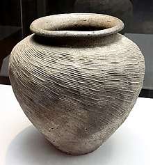
In the second year of the Yōrō (718), Noto Province consisting of the 4 districts of Suzu, Fugeshi, Hakui and Noto was established. For a short period of time, the land was claimed as part of Etchū Province. During this period the famous Ōtomo no Yakamochi recited a poem about the picturesque scenery of Suzu Bay, which would later be included in the famous poetry anthology Man'yōshū. Later in the Kōji period (1143), Noto Provincial Governor Minamoto no Toshikane established Wakayama shōen which grew to become the largest estate in Noto, expanding territory to take over the majority of land in Suzu. Around this time, production of Suzu ware began, which was exported as far as Hokkaido. The area was also noted from ancient times for the production of salt.
During the Sengoku period (1467–1568), the area was contested between the Hatakeyama clan, Uesugi clan and Maeda clan, with the area becoming part of Kaga Domain under the Edo-period Tokugawa shogunate. Following the Meiji Restoration, the area was organised into one town (Iida) and 14 villages in 1889. These municipalities merged on 15 July 1954 to form the city of Suzu.
Government
Suzu has a mayor-council form of government with a directly elected mayor and a unicameral city legislature of 14 members.
Economy
Industries
- Agriculture: (Wet-land rice, Matsutake mushrooms, charcoal, and other crops)
- Commercial fishing: Processing of marine goods
- Livestock: Noto Beef, a regionally renowned brand
- Ceramics: Portable stoves called shichirin and Suzu ware are the chief ceramic goods produced in the city. Also, diatomaceous earth is found almost anywhere within the city limits, and it has been used for ceramics since the Edo period.
- Salt: Salt is still manufactured traditionally with evaporation ponds, particularly through the Agehama method of artificially flooded saltpans
- Sake: There are several sake producers in the area, including the Sougen Sake Brewery
More recently, Suzu has become known for its production of specialized charcoal for use in the Japanese tea ceremony.
Education
Suzu has seven public elementary schools and four middle schools operated by the city government, and one public high school operated by the Ishikawa Prefectural Board of Education. The prefectural also operates one special education school.
Mass Media
Newspapers
- Hokuriku Chunichi Shimbun (Chunichi Shimbun Co.), Suzu Correspondence Division
- Hokkoku Shimbun, Suzu Branch Office
Cable television
- Nouetsu Cablenet
Local attractions
Places
- Suzu Shrine
- Mitsukejima, also called "Battleship Rock"
- Rokkozaki Lighthouse
- Suzu-yaki Museum
- Godzilla Rock
Festivals
- Iida-machi Toroyama Festival (Established by the city as an important intangible folk culture asset in 1996)
- Houryuu Tanabata Kiriko Festival
- Held on the first Saturday of August in Ukai, Houryuu-machi. A 14 meter tall kiriko is carried by a group of young people on their shoulders around the Ukai area in Houryuu-machi. Although the kiriko in Jike, Misaki-machi is recognized as being the biggest in Japan, the kiriko used in this festival is the largest among kiriko that are carried on the shoulders. In the final stages of the festial, with fireworks in the background, the kiriko is pushed towards the sea and the participants do boisterous dance in the sea around pine torches.
External links
| Wikimedia Commons has media related to Suzu, Ishikawa. |
- Official website (in Japanese)
Kanazawa (capital) | ||
| Core city |
| |
| Cities | ||
| Districts | ||
| Authority control |
|
|---|