Stow Bedon
Stow Bedon /ˌstoʊ ˈbɛdən/ is a village of 290 inhabitants in the Breckland district of the English county of Norfolk.
| Stow Bedon | |
|---|---|
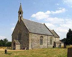 St Botolph, Stow Bedon | |
 Stow Bedon Location within Norfolk | |
| Area | 13.68 km2 (5.28 sq mi) |
| Population | 290 (2011 census)[1] |
| • Density | 21/km2 (54/sq mi) |
| OS grid reference | TL955963 |
| District |
|
| Shire county | |
| Region | |
| Country | England |
| Sovereign state | United Kingdom |
| Post town | ATTLEBOROUGH |
| Postcode district | NR17 |
| Dialling code | 01953 |
| Police | Norfolk |
| Fire | Norfolk |
| Ambulance | East of England |
| UK Parliament | |
The Domesday Book mentions Stow Bedon, but in limited detail. The Inclosure Act, however, mentions Stow Bedon as a 'Free Village' and mentions how the village "maintained an independent spirit". Further records show that during Queen Victoria's Jubilee, instead of the traditional roasting of an ox, Stow Bedon only roasted a pig.
Kelly's Directory for 1883 records that Stow Bedon had a population of 324 with a total of 35 dwellings. It has been assumed in recent times, however, that the true number of houses during this period would have been greater.
Stow Bedon adjoins the hamlet of Lower Stow Bedon although the two often appear to be considered one village and the church of Breckles St Margaret is nearby. The village fete is held annually in June, and the village church, St Botolphs, holds a flower festival.
A station at Stow Bedon, on the Thetford & Watton Railway, opened in October 1869, and closed with the line in June 1964.[2] The Great Eastern Pingo Trail, a 13-kilometre circular walk, starts and finishes in the village. Parking is on the A1075, in the former railway station yard.
Stow Bedon is closely connected to the towns of Watton, Attleborough and Thetford.
Notes
- "Civil Parish population 2011". Neighbourhood Statistics. Office for National Statistics. Retrieved 8 August 2016.
- "Station Name:Stow Bedon". Disused Stations. Retrieved 19 December 2017.
| Wikimedia Commons has media related to Stow Bedon. |