Foxley
Foxley is a village and civil parish in the English county of Norfolk. The village is about 15 miles (24 km) north-west of Norwich and 9 miles (14 km) south-east of Fakenham. It covers an area of 6.66 km2 (2.57 sq mi) and had a population of 279 in 113 households at the 2001 census,[2] increasing slightly to a population of 285 in 125 households at the 2011 Census. For the purposes of local government, it falls within the Upper Wensum Ward of Breckland District Council and the Elmham and Mattishall Division of Norfolk County Council.
| Foxley | |
|---|---|
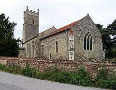 St Thomas, Foxley | |
 Foxley Location within Norfolk | |
| Area | 6.66 km2 (2.57 sq mi) |
| Population | 285 (2011)[1] |
| • Density | 43/km2 (110/sq mi) |
| OS grid reference | TG039218 |
| Civil parish |
|
| District |
|
| Shire county | |
| Region | |
| Country | England |
| Sovereign state | United Kingdom |
| Post town | DEREHAM |
| Postcode district | NR20 |
| Police | Norfolk |
| Fire | Norfolk |
| Ambulance | East of England |
The village is effectively divided into East and West Foxley by the A1067 road that was built as a bypass of it and the nearby village of Bawdeswell. The nearest rail station is at Norwich while the nearest major shopping complex is located in Holt, roughly 14 miles north of the village.
Much of the nearby northern sea coast is part of the Norfolk Coast AONB (Area of Outstanding Natural Beauty). The community of Cromer, on the coast, is approximately 40 minutes from Foxley by automobile; Hunstanton, also on the coast (but further north), is a slightly longer drive.[3][4]
Notes
- "Civil Parish population 2011". Neighbourhood Statistics. Office for National Statistics. Retrieved 4 August 2016.
- Census population and household counts for unparished urban areas and all parishes. Office for National Statistics & Norfolk County Council (2001). Retrieved 20 June 2009.
- Foxley Lodge
- Norfolk AREA OF OUTSTANDING NATURAL BEAUTY
- Parish Summary: Foxley
- Foxley Norfolk
- Foxley War Memorial
- Foxley Lodge, Other nearby listed buildings
- The country home of Percy Bysshe Shelley and his family comes up for sale, along with 111 rolling acres of Sussex
- See inside this period rectory for sale for £1.195m
- Parish Summary: Foxley
- CHURCH OF ST THOMAS
- http://www.heritage.norfolk.gov.uk/record-details?MNF7221-St-Thomas%27-Church-Foxley&Index=6587&RecordCount=57338&SessionID=4fbf0223-d445-454b-a0a5-9da707ce7ee1 St Thomas' church]
- [https://www.achurchnearyou.com/church/10054/ Church of England, Diocese of Norwich, Foxley, St Thomas]
- Visit Foxley Wood
- "Foxley Wood National Nature Reserve" (PDF). Natural England. Archived from the original (PDF) on 11 January 2011. Retrieved 31 December 2010.