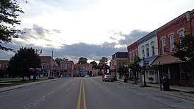
Stockbridge, Michigan
Stockbridge is a village in Stockbridge Township, Ingham County in the U.S. state of Michigan, and lies 36.4 miles (58.6 km) from downtown Lansing. The population was 1,218 at the 2010 census.
Stockbridge, Michigan | |
|---|---|
 | |
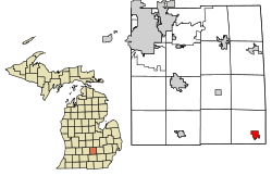 Location of Stockbridge, Michigan | |
 Stockbridge Location within the state of Michigan | |
| Coordinates: 42°26′56″N 84°10′42″W | |
| Country | United States |
| State | Michigan |
| County | Ingham |
| Area | |
| • Total | 1.52 sq mi (3.94 km2) |
| • Land | 1.50 sq mi (3.89 km2) |
| • Water | 0.02 sq mi (0.04 km2) |
| Elevation | 938 ft (286 m) |
| Population | |
| • Total | 1,218 |
| • Estimate (2018)[3] | 1,253 |
| • Density | 821.69/sq mi (317.18/km2) |
| Time zone | UTC-5 (Eastern (EST)) |
| • Summer (DST) | UTC-4 (EDT) |
| ZIP code | 49285 |
| Area code(s) | 517 |
| FIPS code | 26-76560[4] |
| GNIS feature ID | 0638853[5] |
| Website | Official website |
Geography
According to the United States Census Bureau, the village has a total area of 1.53 square miles (3.96 km2), of which 1.51 square miles (3.91 km2) is land and 0.02 square miles (0.05 km2) is water.[6] The westernmost trailhead of Lakelands Trail State Park is located within Stockbridge at 42°26′43″N 84°10′47″W and travels 26 miles (42 km) east to Hamburg Township.
| Historical population | |||
|---|---|---|---|
| Census | Pop. | %± | |
| 1880 | 160 | — | |
| 1890 | 497 | 210.6% | |
| 1900 | 677 | 36.2% | |
| 1910 | 663 | −2.1% | |
| 1920 | 749 | 13.0% | |
| 1930 | 715 | −4.5% | |
| 1940 | 852 | 19.2% | |
| 1950 | 1,098 | 28.9% | |
| 1960 | 1,097 | −0.1% | |
| 1970 | 1,190 | 8.5% | |
| 1980 | 1,213 | 1.9% | |
| 1990 | 1,202 | −0.9% | |
| 2000 | 1,260 | 4.8% | |
| 2010 | 1,218 | −3.3% | |
| Est. 2018 | 1,253 | [3] | 2.9% |
| U.S. Decennial Census[7] | |||
2010 census
As of the census[2] of 2010, there were 1,218 people, 481 households, and 328 families living in the village. The population density was 806.6 inhabitants per square mile (311.4/km2). There were 552 housing units at an average density of 365.6 per square mile (141.2/km2). The racial makeup of the village was 96.7% White, 0.2% African American, 0.9% Native American, 0.2% Asian, 0.1% from other races, and 1.8% from two or more races. Hispanic or Latino of any race were 3.1% of the population.
There were 481 households of which 39.9% had children under the age of 18 living with them, 46.4% were married couples living together, 17.0% had a female householder with no husband present, 4.8% had a male householder with no wife present, and 31.8% were non-families. 27.9% of all households were made up of individuals and 12.3% had someone living alone who was 65 years of age or older. The average household size was 2.53 and the average family size was 3.09.
The median age in the village was 36.8 years. 29.4% of residents were under the age of 18; 8.2% were between the ages of 18 and 24; 23.4% were from 25 to 44; 26.6% were from 45 to 64; and 12.3% were 65 years of age or older. The gender makeup of the village was 46.8% male and 53.2% female.
2000 census
As of the census[4] of 2000, there were 1,260 people, 480 households, and 322 families living in the village. The population density was 866.1 per square mile (335.5/km²). There were 510 housing units at an average density of 350.6 per square mile (135.8/km²). The racial makeup of the village was 97.70% White, 0.79% Native American, 0.24% Asian, 0.48% from other races, and 0.79% from two or more races. Hispanic or Latino of any race were 1.03% of the population.
There were 480 households out of which 35.8% had children under the age of 18 living with them, 52.5% were married couples living together, 10.8% had a female householder with no husband present, and 32.9% were non-families. 29.6% of all households were made up of individuals and 14.0% had someone living alone who was 65 years of age or older. The average household size was 2.53 and the average family size was 3.17.
In the village, the population was spread out with 28.0% under the age of 18, 7.9% from 18 to 24, 30.5% from 25 to 44, 18.4% from 45 to 64, and 15.2% who were 65 years of age or older. The median age was 35 years. For every 100 females, there were 83.1 males. For every 100 females age 18 and over, there were 80.3 males.
The median income for a household in the village was $38,456, and the median income for a family was $47,250. Males had a median income of $40,625 versus $26,250 for females. The per capita income for the village was $17,614. About 8.3% of families and 11.6% of the population were below the poverty line, including 17.0% of those under age 18 and 7.6% of those age 65 or over.
References
- "2017 U.S. Gazetteer Files". United States Census Bureau. Retrieved Jan 3, 2019.
- "U.S. Census website". United States Census Bureau. Retrieved 2012-11-25.
- "Population and Housing Unit Estimates". Retrieved February 9, 2020.
- "U.S. Census website". United States Census Bureau. Retrieved 2008-01-31.
- "US Board on Geographic Names". United States Geological Survey. 2007-10-25. Retrieved 2008-01-31.
- "US Gazetteer files 2010". United States Census Bureau. Archived from the original on January 12, 2012. Retrieved 2012-11-25.
- "Census of Population and Housing". Census.gov. Retrieved June 4, 2015.
External links
Municipalities and communities of Ingham County, Michigan, United States | ||
|---|---|---|
| Cities | 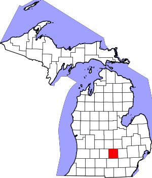 Map of Michigan highlighting Ingham County | |
| Villages | ||
| Charter townships | ||
| General law townships | ||
| CDPs | ||
| Other unincorporated communities | ||
| Footnotes | ‡This populated place also has portions in an adjacent county or counties | |
| Authority control |
|
|---|