Stanovoy Range
The Stanovoy Range (Russian: Станово́й хребе́т, Stanovoy khrebet; simplified Chinese: 外兴安岭; traditional Chinese: 外興安嶺; pinyin: Wài Xīng'ān Lǐng), is a mountain range located in the southern Sakha Republic, Far Eastern Federal District. It is also known as Sükebayatur and Sükhbaatar in Mongolian, Stanovoy Mountains, or Outer Khingan Range. The range was first studied and scientifically described by Russian researcher Alexander von Middendorff.[1]
| Stanovoy Range | |
|---|---|
| Outer Khingan | |
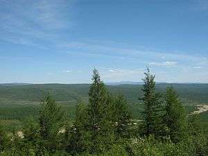 View of some larch woods in the range. | |
| Highest point | |
| Peak | Mount Skalisty |
| Elevation | 2,412 metres (7,913 ft) |
| Coordinates | 56°20′N 126°00′E |
| Dimensions | |
| Length | 720 km (450 mi) SW/NE |
| Width | 180 km (110 mi) NW/SE |
| Geography | |
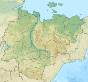 Stanovoy Range Location in the Sakha Republic (Yakutia) | |
| Country | Russia |
| Federal subject | Sakha Republic, Far Eastern Federal District |
| Parent range | South Siberian Mountains |
| Geology | |
| Type of rock | Shale, gneiss and granite intrusions |
Geography
The range runs south-west to north-east for almost 800 km, from the Olyokma River in the west, to the Uchur River in the east.[2] almost to the Sea of Okhotsk. It separates the watershed of the Arctic Ocean (via the Lena) from that of the Pacific Ocean (via the Amur). For this reason, it was the border between Russia and China from 1689 (Treaty of Nerchinsk) to 1858 (Treaty of Aigun). The Aldan Highlands are located to the north of the range and the Yankan – Tukuringra – Soktakhan – Dzhagdy group of mountain ranges to the south.
The highest point of the range is Mount Skalisty at 2,412 meters (7,913 ft). The range has many glaciers, which are the main source of the Lena River.
The Yablonovy Range may be considered a southwestern extension of the Stavonoy. Before the 20th century, Stanavoy could also refer to a somewhat mythical range along the west coast of the Sea of Okhotsk.
References
- Stanovoy Range - article from the Great Soviet Encyclopedia.
- The Mountains of Southern Siberia
External links