Stanovoy Highlands
The Stanovoy Highlands (Russian: Станово́е наго́рье) or Stanovoy Uplands is a mountain range in the Transbaikal region of Siberia, Russia.[1]
| Stanovoy Highlands | |
|---|---|
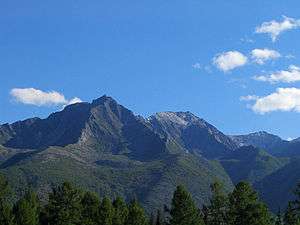 View of the Northern Mui, a subrange of the highlands | |
| Highest point | |
| Peak | Pik BAM |
| Elevation | 3,072 m (10,079 ft) |
| Coordinates | 56°51′54.85″N 117°34′47.32″E |
| Dimensions | |
| Length | 700 km (430 mi) ENE-WSW |
| Geography | |
 | |
| Country | Russia |
| Federal subject | Buryatia |
| Range coordinates | 56°5′0″N 114°30′0″E |
| Parent range | South Siberian Mountains |
Geography
Stanovoy Highlands is a mountainous area stretching roughly in a WSW / ENE direction between the northern part of Lake Baikal in the west to the Olyokma River in the east. There are large intermontane basins of the Baikal type, such as the Verkhne-Angar at altitudes ranging between 500 m (1,600 ft) and 1,000 m (3,300 ft).
Subranges
The system of the Stanovoy Highlands comprises a group of subranges, including the following:[2]
- Southern Mui Range (Южно-Муйский хребет), highest point Muisky Gigant, 3,067 metres (10,062 ft)
- Northern Mui Range (Северо-Муйский хребет), highest point 2,537 metres (8,323 ft)
- Kodar Range (Кодар), highest point Pik BAM, 3,072 metres (10,079 ft)
- Udokan Range (Удокан ), highest point 2,561 metres (8,402 ft)
- Kalar Range, highest point Skalisty Golets, 2,519 metres (8,264 ft)
- Synnyr Massif
- Delyun-Uran
References
- Кулаков, В.С.; Юргенсон, Г.А. "Становое нагорье" [Stanovoy Highlands] (in Russian). Энциклопедия Забайкалья. Retrieved 29 August 2015.
- Oleg Leonidovič Kryžanovskij, A Checklist of the Ground-beetles of Russia and Adjacent Lands. p. 15
This article is issued from Wikipedia. The text is licensed under Creative Commons - Attribution - Sharealike. Additional terms may apply for the media files.