Aldan Highlands
The Aldan Highlands, or Aldan Plateau (Russian: Алданское нагорье, tr. Aldanskoye Nagorye; Yakut: Алдан үрдэлэ)[2] are a mountainous area in the Sakha Republic, Far Eastern Federal District, Russia.
| Aldan Highlands | |
|---|---|
| Алданское нагорье / Алдан үрдэлэ | |
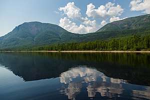 View of Lake Bolshoye Toko | |
| Highest point | |
| Elevation | 2,306 m (7,566 ft) |
| Dimensions | |
| Length | 600 km (370 mi) |
| Width | 300 km (190 mi) |
| Geography | |
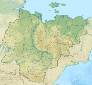 Location in the Sakha Republic, Russia | |
| Country | Russia |
| Federal subject | Sakha Republic |
| Range coordinates | 57°0′N 128°0′E |
| Parent range | South Siberian System |
| Geology | |
| Age of rock | Precambrian[1] and Late Archaean |
| Type of rock | Gneiss, slate and Granulite, amphibolite |
| Climbing | |
| Easiest route | from Aldan |
The Olyokma Nature Reserve is a protected area located on the northwestern side, partly within the neighboring Lena Plateau.[3]
History
The area of the Aldan and the Yudoma-Maya highlands, between the basins of the Aldan River and the Yudoma, was uncharted territory well until the 1930s. It was first surveyed in 1934 by geologist Yuri Bilibin (1901—1952) together with mining engineer Evgeny Bobin (1897—1941) in the course of an expedition sent by the government of the USSR. Bilibin and Bobin made a thorough topographic survey of the mountainous region leading separate research parties.[4]
Geography
The Aldan Highlands are located at the southern end of the Sakha Republic, between the Aldan River and the Uchur River. The Aldan partly crosses the uplands in the north, in the same manner as the Amga River in the west. The highlands are limited by the Stanovoy Range to the southwest, south and southeast, and by the Olyokma River in the northwest, beyond which lies the Lena Plateau. Besides the Aldan and the Amga, the rivers of the highlands include the Buotama, the Amedichi, the Elkon, the Ulu, the Bolshoy Nimnyr, the Timpton and the Tuolba.[5]
Aldan town and Tommot are located in the northern area of the highlands and Chulman in the south.[6]
Subranges
The system of the Aldan Highlands comprises a number of subranges. Mountains are of middle height and their relief is usually smooth. The highest point is an unnamed 2,306 m (7,566 ft) summit. The ranges within the uplands include the following:[7]
- Western Yangi Range, highest point Mount Evota 1,603 metres (5,259 ft)
- Sunnagyn Range (Aldan-Uchur), highest point 2,246 metres (7,369 ft)
- Ket-Kap Range, highest point 1,493 metres (4,898 ft)
- Tommot Range, highest point 1,616 metres (5,302 ft)
- Killakh Range, a low mountain chain rising on the side of the Aldan River.
_-_panoramio.jpg) The Aldan River flowing across the highlands. |
.jpg) A bend in the Chulman River. |
Geology
The highlands are composed of Archean crystalline slates and gneisses. The Aldan Highlands coincide geographically with the Aldan Shield, a geological region that is an exposed part of the Siberian Craton. Together with the Anabar Shield further to the northwest, the Aldan Shield is one of the main features of the craton.[8]
Flora
The mountains of the highlands are covered by larch taiga up to elevations between 1,100 and 1,300 m and by rocky tundra at higher altitudes.[5]
References
- The tectonics and metallogeny of the Precambrian of the Aldan-Stanovoy Shield
- Геоморфология России (Geomorphology of Russia)
- "Olyokma Zapovednik (Official Site)" (in Russian). Ministry of Natural Resources and Environment (Russia). Archived from the original on 22 May 2013. Retrieved 15 November 2019.
- Essays on the History of Geographical Discoveries (in Russian)
- Алданское нагорье / Great Russian Encyclopedia; in 35 vol.] / Ch. ed. Yu.S. Osipov . - M .: Great Russian Encyclopedia, 2004—2017.
- Google Earth
- Oleg Leonidovič Kryžanovskij, A Checklist of the Ground-beetles of Russia and Adjacent Lands. p. 15
- Archean crustal evolution of the Aldan Shield, Siberia: Geochemical and Isotopic Constraints