Stanley Mission
Stanley Mission is a First Nations settlement in the boreal forest northern Saskatchewan, Canada. Its location is on the banks of the Churchill River, 80 km (50 mi)s north east of the town of La Ronge, 305 km (190 mi) north of Prince Albert. Access is provided by Highway 915.
Stanley Mission | |
|---|---|
Community | |
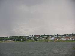 Stanley Mission across the Churchill River | |
 Stanley Mission Location of Stanley Mission  Stanley Mission Stanley Mission (Canada) | |
| Coordinates: 55°24′45″N 104°34′08″W | |
| Country | Canada |
| Province | Saskatchewan |
| Founded | 1851 |
| Government | |
| • Type | Canadian First Nation (Indian band) |
| • Chief | Tammy Cook-Searson |
| Elevation | 377 m (1,237 ft) |
| Time zone | UTC−06:00 (CST) |
| Postal code | S0J 2P0 |
| Area code(s) | 306 |
| Website | http://www.stanleymission.com/ |
The community consists of the northern settlement of Stanley Mission with a population of 124[1] and Stanley 157, IRI a reserve of the Lac La Ronge Indian Band band government with a population of 1,634.[2]
History
People have lived in the area for several thousands of years. Across the river at the original site of Stanley Mission is Holy Trinity Anglican Church, built between 1854 and 1860. It is the oldest standing building in Saskatchewan.
The community was founded in 1851.[3] The name was derived from Stanley Park, a now-former manor house in Selsley, Gloucestershire, England, which had been the home of the wife of the Rev. Robert Hunt, an Anglican missionary.[4]
Attractions
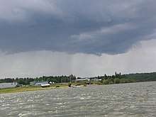
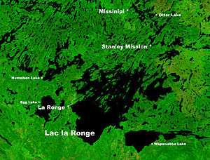
The community has two stores, a band office, a health office, elementary and high schools, a post-secondary learning centre, a community hall, arena (ice skating and hockey), other services. It is an access point to the northern parts of Lac La Ronge Provincial Park, several tourist fishing camps, and a major recreational canoe route, formerly part of the voyageurs trade routes used by the Hudson's Bay Company and North West Company. It is the closest road access to Nistowiak Falls, one of the tallest in Saskatchewan. There are ancient pictograph sites in the vicinity. Otter Rapids 5 km (3.1 mi) north of the settlement of Missinipe (Missinipi) are the next landmarks and community along Highway 102, to the north on the Churchill River (Missinipeis also the Woodland Cree name for the Churchill River).
Notable people
References
- "Search for Municipal Information". Government of Saskatchewan. Retrieved April 7, 2014.
- "Statistics Canada (Community profiles)". Retrieved 2014-05-25.
- Crean, Frank Joseph Patrick (1910). New northwest exploration. Ottawa: Government Printing Bureau for Department of the Interior. pp. 40–42.
- Barry, Bill (September 2005). Geographic Names of Saskatchewan. Regina, Saskatchewan: People Places Publishing, Ltd. p. 400. ISBN 1-897010-19-2.
External links
- Stanley Mission (Lac La Ronge Indian Band website
- Holy Trinity Anglican Church information
- Historic aerial photos of Stanley Mission, Saskatchewan Council for Archives and Archivists
- Lac La Ronge Provincial Park
- Encyclopedia of Saskatchewan
| Subdivisions | |
|---|---|
| Communities | |
| Cities | |
| Topics |
|
| |
