St Austell railway station
St Austell station is a Grade II listed[1] station which serves the town of St Austell, Cornwall, England. It is 286 miles (460 km) from London Paddington via Bristol Temple Meads. The station is operated by Great Western Railway, as is every other station in Cornwall.
| St Austell | |
|---|---|
 | |
| Location | |
| Place | St Austell |
| Local authority | Cornwall |
| Coordinates | 50.3397°N 4.79028°W |
| Grid reference | SX016525 |
| Operations | |
| Station code | SAU |
| Managed by | Great Western Railway |
| Number of platforms | 2 |
| DfT category | C2 |
| Live arrivals/departures, station information and onward connections from National Rail Enquiries | |
| Annual rail passenger usage* | |
| 2014/15 | |
| 2015/16 | |
| 2016/17 | |
| 2017/18 | |
| 2018/19 | |
| History | |
| Original company | Cornwall Railway |
| Pre-grouping | Great Western Railway |
| Post-grouping | Great Western Railway |
| 1859 | Opened |
| 1931 | Level crossing closed |
| 2001 | Main building rebuilt |
| Listed status | |
| Listed feature | St Austell Railway Station and Footbridge |
| Listing grade | Grade II listed |
| Entry number | 1268442[1] |
| Added to list | 29 May 1988 |
| National Rail – UK railway stations | |
| |
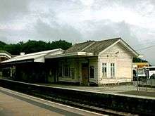
The station is situated on the hillside just above the town. The main buildings were rebuilt in 2001 and face the town's bus station.
The station is served by both local and long-distance trains, including the Night Riviera sleeper service.[2]
History
St Austell opened with the Cornwall Railway on 4 May 1859.[3] A report when the station opened stated that
- the departure station is an ornamental wooden structure, having projecting verandahs at each side, waiting room, ticket office, &c., similar to the corresponding building at Lostwithiel. Nearly opposite is the arrival station, which is built of stone, with projecting verandah over the platform and having convenient waiting, porters', and lamp rooms. To the south of this is the goods shed, a stone building of the same dimensions as the goods shed at Lostwithiel, and the provision has been made here, for the accommodation of the heavy goods traffic that is anticipated from the district. Amongst other arrangements adopted, with the view of preventing collisions and inconvenience, it has been determined that the passenger traffic shall pass to the station through a street in front of the post office, and the goods traffic by Menacuddle Hill, in front of the Town Hall.[4]
The goods shed was adjacent to the road which passed over the line on a level crossing. This was not authorised by the original Act of Parliament but was deemed unavoidable unless the road was given a very steep bridge to climb over the line. Palace Road was built along the back of the station in 1862 to make it possible for traffic from the east of the town to avoid the level crossing.[5] The level crossing was finally closed on 21 September 1931.[6] Road traffic now needs to cross the line on the bridge at the other end of the station, but a footbridge allows foot traffic to still cross the line at the old place.
A large warehouse was added on the town side of the line in 1862 (where St Austell Bus Station now stands), financed by selling the land to a third party who then leased it back to the company. It was replaced by a large new goods depot (200 feet long by 40 feet wide) a short distance east of the station on 2 November 1931. For many years the original goods yard was used by Motorail trains which carried cars to Cornwall from London and many other places in England.
As well as the general traffic for a busy town, the station handled large volumes of china clay from the surrounding district, and of fish from Mevagissey. The steep hill from the town to the station caused problems for the horses hauling heavy wagons.
The Cornwall Railway was amalgamated into the Great Western Railway on 1 July 1889. The Great Western Railway was nationalised into British Railways from 1 January 1948 which was in privatised in the 1990s.
A listed GWR covered footbridge which dated from 1882 linked the platforms[1] but was superseded by an accessible bridge in 2015. The old bridge remained in place but out of use until February 2019 when it was given to the Helston Railway by Network Rail.[7]
| Preceding station | Historical railways | Following station | ||
|---|---|---|---|---|
| Par | Great Western Railway | Burngullow | ||
Signalling

St Austell was a passing place from the opening of the Cornwall Railway and rudimentary signalling was provided operated, as was usual at the time, by men who had to walk between the different signals and points, and the level crossing at the west end of the platform. A signal box was eventually provided at the west end of the station on the south side of the line.[8]
The line was doubled towards Par on 15 October 1893 and towards Burngullow on 26 March 1899. Around 1905 a new Great Western Railway Type 7C signal box was built on the opposite side of the line. A new goods yard was opened east of the station and the level crossing was closed on 2 November 1931 when a new 43-lever frame was provided in the signal box.[9]
The signal box closed on 22 March 1980 when control of trains through the station was transferred to the signal box at Par.
Description

The main building is on the south side of the line, nearest the town centre and facing the bus station. It was built in 2001 to a design by Lacie Hickie Caley.[10] and contains a booking office and shop. The south side is Platform 1 which is used by trains running from east to west so it is the arrival platform for services from London Paddington and Plymouth and departure platform for Truro and Penzance.
Platform 2 is used by trains running from west to east. The wooden building on this platform dates from Great Western Railway days. The station car park is situated behind this platform. An accessible footbridge links the two platforms.
At the east end of the platform is a road bridge carrying Carlyon Road over the line and beyond this is a small cutting which is spanned by a footbridge. The original bridge survived for almost 150 years; it was extended when the extra line was laid in 1931 to the new goods yard, but both sections have now been replaced by Network Rail's prototype modular fibre reinforced polymer footbridge.[11]
Passenger volume
St Austell is the fourth busiest station in Cornwall after Truro, Penzance and St Ives. Comparing the year April 2011 to March 2012 with that which started in April 2002, passenger numbers increased by 75%.[12]
| 2002-03 | 2004-05 | 2005-06 | 2006-07 | 2007-08 | 2008-09 | 2009-10 | 2010-11 | 2011-12 | |
|---|---|---|---|---|---|---|---|---|---|
| Entries | 132,408 | 136,333 | 138,787 | 156,885 | 181,063 | 220,504 | 197,611 | 218,220 | 233,355 |
| Exits | 134,268 | 138,724 | 142,758 | 157,728 | 179,421 | 220,504 | 197,611 | 218,220 | 233,355 |
| Total | 266,676 | 275,056 | 281,545 | 314,613 | 360,484 | 441,008 | 395,222 | 436,440 | 466,710 |
The statistics cover twelve month periods that start in April.
Services

St Austell is served by all Great Western Railway trains on the Cornish Main Line between Penzance and Plymouth with one train per hour in each direction. Some trains run through to or from London Paddington station via Exeter St Davids, including the Night Riviera overnight sleeping car service. There are a limited number of CrossCountry trains providing a service to destinations such as Birmingham New Street, Wolverhampton, Manchester Piccadilly, Leeds, York, Edinburgh and Glasgow Central in the morning and returning in the evening.[13]
| Preceding station | Following station | |||
|---|---|---|---|---|
| Truro | Great Western Railway Cornish Main Line |
Par | ||
| CrossCountry Cornish Main Line |
||||
Viaducts
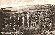
Just to the west of St Austell are two viaducts, both originally built on stone piers with timber tops, they were rebuilt in stone in 1898 - 1899. The first is known as St Austell Viaduct. It is 720 feet long and crosses 115 feet above the Trenance valley. The second is Gover Viaduct, 95 feet high and 690 feet long on 10 piers.[14]
References
- Historic England, "St Austell Railway Station and Footbridge (1268442)", National Heritage List for England, retrieved 4 January 2017
- Table 135 National Rail timetable, May 2016
- Clinker, CR (1963). The Railways of Cornwall 1809 - 1963. Dawlish: David and Charles.
- West Briton and Cornwall Advertiser, Railway Special Edition, 1859
- Records of the Cornwall Railway in The National Archives at Kew
- Bennett, Alan (1988). The Great Western Railway in Mid Cornwall. Southampton: Kingfisher Railway Publications. ISBN 0-946184-53-4.
- "St Austell's Victorian footbridge finds new home at Helston heritage railway". Network Rail Media Centre. Retrieved 28 August 2019.
- Cooke, RA (1977). Track Layout Diagrams of the GWR and BR WR, Section 11: East Cornwall. Harwell: RA Cooke.
- Pryer, GA (2000). Signal Box Diagrams of the Great Western & Southern Railways, Volume 16: GWR Lines in West Cornwall. Weymouth: GA Pryer. ISBN 0-9532460-5-1.
- Beacham, Peter; Pevsner, Nikolaus (2014). The Buildings of England. Cornwall. Yale University Press. p. 499. ISBN 9780300126686.
- Ford, Roger (2008). "Network Rail – the future is modular". Modern Railways. Ian Allan Publishing. 65 (215): 59–63. ISSN 0026-8356.
- "Estimates of station usage". Office of Rail Regulation. Retrieved 26 July 2013.
- Table 51 National Rail timetable, May 2016
- Binding, John (1993). Brunel's Cornish Viaducts. Penryn: Atlantic Transport Publishing/Historical Model Railway Society. ISBN 0-906899-56-7.
External links
| Wikimedia Commons has media related to St Austell railway station. |
Cornwall Portal | |
| Unitary authorities | |
| Major settlements |
|
| Rivers | |
| Topics | |