Lelant railway station
Lelant railway station is on the waterfront of the Hayle estuary below the village of Lelant in Cornwall, United Kingdom. It is 322 miles (518 km) from London Paddington via Bristol Temple Meads. It was opened in 1877 and trains now call on request only.
| Lelant | |
|---|---|
 | |
| Location | |
| Place | Lelant |
| Local authority | Cornwall |
| Coordinates | 50.184°N 5.437°W |
| Grid reference | SW547372 |
| Operations | |
| Station code | LEL |
| Managed by | Great Western Railway |
| Number of platforms | 1 |
| DfT category | F2 |
| Live arrivals/departures, station information and onward connections from National Rail Enquiries | |
| Annual rail passenger usage* | |
| 2014/15 | |
| 2015/16 | |
| 2016/17 | |
| 2017/18 | |
| 2018/19 | |
| History | |
| Original company | Great Western Railway |
| Opened | 1877 |
| National Rail – UK railway stations | |
| |
History
The station was opened by the Great Western Railway on 1 June 1877 on their new branch line from St Erth to St Ives. No goods sidings were ever provided at the station, but a line was laid from the station out to sidings on Lelant Wharf where traffic could be transferred between railway wagons and boats. The St Ives branch was laid using 7 ft (2,134 mm) broad gauge, but in October 1888 a third rail was added to the line from St Erth to allow 4 ft 8 1⁄2 in (1,435 mm) standard gauge goods trains to reach the wharf. The last broad gauge train ran on Friday 20 May 1892; since the following Monday all trains have been standard gauge.[1]
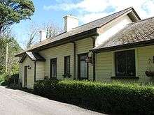
Goods traffic was withdrawn in May 1956[2] and the station is now unstaffed. The original wooden station building is now a private dwelling and has been extended in a sympathetic style. The village is at the top of the road that climbs the hill opposite the station entrance. The Old Station house was renovated in July 2009 and serves cream teas. A level crossing at the St Erth end of the platform gave access to a slipway with the crossing gates hung on granite pillars in the local style. Three of these pillars still stand by the line.
Description
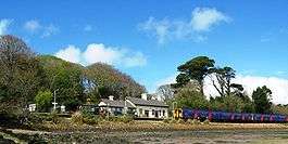
The station is 1 mile (1.6 km) north of St Erth and faces the Hayle Estuary. There is just a single platform, which is on the left of trains arriving from St Erth.[3]
Limited car parking is available, adjacent to the platform. The village is at the top of the road that climbs the hill opposite the station entrance.
Services
For several years up to May 2019, the station was served by a limited service of trains running between St Erth and St Ives. Since then, due to the reduction of services at Lelant Saltings, the station has a more regular service but still with gaps of up to two hours between services.
Lelant is a request stop. This means passengers wanting to join the train need to signal to the driver, and those who wish to alight need to inform the conductor.
| Preceding station | Following station | |||
|---|---|---|---|---|
| St Erth | Great Western Railway St Ives Bay Line |
Carbis Bay | ||
References
| Wikimedia Commons has media related to Lelant railway station. |
- MacDermot, E T (1931). History of the Great Western Railway. 2 (1863-1921) (1 ed.). London: Great Western Railway. ISBN 0-7110-0411-0.
- Jenkins, Stanley C (1992). "the St Ives Branch". Great Western Railway Journal. Wild Swan Publications Ltd (Cornish Special Issue): 2–34.
- Jacobs, Gerald (2005). Railway Track Diagrams Book 3: Western. Bradford-on-Avon: Trackmaps. ISBN 0-9549866-1-X.
| This station offers access to the South West Coast Path | |
|---|---|
| Distance to path | 0.25 miles (0.40 km) |
| Next station anticlockwise | Carbis Bay 1 mile (1.6 km) |
| Next station clockwise | Lelant Saltings 0.25 miles (0.40 km) |