Wadebridge
Wadebridge (/ˈweɪdbrɪdʒ/; Cornish: Ponswad[1]) is a town and civil parish in north Cornwall, England, United Kingdom. The town straddles the River Camel 5 miles (8.0 km) upstream from Padstow.[2] The permanent population was 6,222 in the census of 2001, increasing to 7,900 in the 2011 census.[3] There are two electoral wards in the town (East and West). Their total population is 8,272[4][5]
Wadebridge
| |
|---|---|
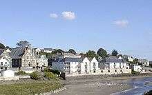
 The Platt in Wadebridge looking at the Clock Tower | |
 Wadebridge Location within Cornwall | |
| Population | 7,900 (2011) |
| OS grid reference | SW990725 |
| Civil parish |
|
| Unitary authority | |
| Ceremonial county | |
| Region | |
| Country | England |
| Sovereign state | United Kingdom |
| Post town | WADEBRIDGE |
| Postcode district | PL27 |
| Dialling code | 01208 |
| Police | Devon and Cornwall |
| Fire | Cornwall |
| Ambulance | South Western |
| UK Parliament | |
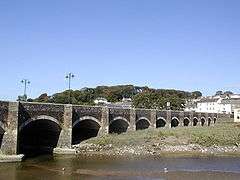
Originally known as Wade, it was a dangerous fording point across the river until a bridge was built here in the 15th century, after which the name changed to its present form. The bridge was strategically important during the English Civil War, and Oliver Cromwell went there to take it. Since then, it has been widened twice and refurbished in 1991.
Wadebridge was served by a railway station between 1834 and 1967; part of the line now forms the Camel Trail, a recreational route for walkers, cyclists and horse riders. The town used to be a road traffic bottleneck on the A39 road until it was bypassed in 1991, and the main shopping street, Molesworth Street, is now pedestrianised.
The town has a secondary school where several notable sports-people were educated. The Royal Cornwall Show is a three-day agricultural show held at the nearby Royal Cornwall Showground every June, and the 5-day Cornwall Folk Festival takes place around the August Bank Holiday.
History
Early history
The initial settlement of Wade (the name of Wadebridge before the bridge was built)[6] came about due to a ford in the River Camel (Camel probably meaning "crooked one"[7]). The early crossing had a chapel on each side of the river, "King's" chapel on the north side and "St Michael's" on the south side. People would pray for a safe crossing at one of the chapels before wading across at low tide, once they had made it the other side they would give thanks to God in the other chapel. In 1312 a licence was granted for a market at Wade. Wade was part of the parish of St Breock and the river separated it from the neighbouring parish of Egloshayle.
At some time the ford was supplemented by a ferry[8] until the Reverend Thomas Lovibond (the vicar of Egloshayle) became distressed at the number of humans and animals that died during the crossing of the River Camel so he planned the building of a bridge which was completed in 1468. Wade was now known as Wadebridge. When John Leland travelled through Cornwall in the early 16th century he wrote that the piers were resting on packs of wool.[9] Begun in 1468 and completed in 1485, the bridge was traditionally known as the "Bridge on Wool" because it was reputedly built on wool sacks. In fact, however, it has been proven to be founded directly on the underlying bedrock.[10]
The bridge was a strategic position in the English Civil War as in 1646 Oliver Cromwell came with 500 Dragoons and 1,000 horsemen to take the bridge.[11] When the bridge was first completed tolls were charged for its maintenance. In 1853 it was widened from 3 to 5 metres (9.8 to 16.4 ft). A second widening took place in 1952[8] and then in 1963 it was again widened taking it to 12 metres (39 ft).
Railway
The Bodmin and Wadebridge Railway from Wadebridge to Wenfordbridge with branch lines to Bodmin and Ruthernbridge[12] was built at a cost of £35,000 following a study commissioned in 1831 by local landowner Sir William Molesworth of Pencarrow. The line was intended to carry sand from the Camel Estuary to inland farms for use as fertiliser. It was opened on 30 September 1834 with the locomotive Camel pulling a train load of 400 passengers (one of the first railways in Britain to carry passengers). When the company ordered its second locomotive it came with a name plate already affixed. It had been named the Elephant as the makers had failed to realise that the first engine had been named after the river and not an animal.[13]
The last passenger train left Wadebridge railway station in 1967 following railway cutbacks. The railway has been transformed into the Camel Trail, and the Bodmin and Wenford Railway heritage railway runs on part of the route.
Quays
Wadebridge was the highest navigable point on the River Camel providing the main trade route before the building of the railway, and coasters would bring goods from Bristol and coal from South Wales. Timber was also imported from the Baltic,[14] while stone from inland was sent to destination throughout England. The first locomotives used on the railway were also imported through the quay, being manufactured by Neath Abbey Ironworks,[13] and the railway initially linked with river traffic well, having been designed to distribute sand from the river to the local farms. This commodity, brought up from Padstow in barges, had previously been taken as far as Michaelstow and Blisland.[15]
In 1880 there were quays on both sides of the river below the bridge, that on the west bank being served by the railway.[16] There was also a "sand dock" constructed upstream of the bridge at the point where the Treguddick Brook (Polmorla Brook) flows into the River Camel, although this had been filled in by 1895[14]
In the 1900s vessels such as the M.V. Florence brought cargos such as slag (for fertiliser), grain and coal. Flour was also a regular cargo brought from Ranks at Avonmouth. However, in the 1950s the river silted badly so that the ketch Agnes was possibly the last vessel to bring cargo to Wadebridge in 1955.[14]
Eddystone Road
In 1877, after cracks appeared in the rock on which the Eddystone Lighthouse was positioned, a new lighthouse was commissioned from James Nicholas Douglass. Granite quarried from De Lank quarry was brought down to Wadebridge where stonemasons dovetailed each segment of stone not only to each other but also to the courses above and below. As each layer was completed and checked to fit with the layer above, it was sent out to the Eddystone rocks by sea. The lighthouse was completed in 1882. This resulted in the road where the masons worked being called Eddystone Road.
World War 1
During World War 1 Wadebridge was home to refugees from the Netherlands and Belgium. In order to support them, a property in Park Street was converted into a Calvinist chapel.[17]
World War 2
Despite the rural nature of the area and the lack of military installations, during World War 2 there was a single recorded air raid when three bombs were dropped on the hill above Fernleigh Road. Residents report hearing the bombs whistling as they fell and landed in a field above the nearest houses. There were no casualties and only minor damage.[18]
Government
Wadebridge is in the constituency of North Cornwall which is currently held by the Conservative MP Scott Mann. The main offices of the former North Cornwall District Council were at Trenant Road in the town.
Historically Wadebridge was part of St Columb Rural District Council until the creation of Wadebridge Urban District Council in April 1898.[14]
Geography and transport
The town straddles the River Camel 5 miles (8.0 km) upstream from Padstow[2] the town centre being on the left bank of the river.
For many years Wadebridge was a traffic-congested town (through which the route of the A39 trunk road passed) but in 1991 the Wadebridge bypass was opened together with the Egloshayle bypass causing the two settlements to regain much of their former charm. The main shopping street in Wadebridge (Molesworth Street) has subsequently been pedestrianized through construction of an inner link road, allowing traffic-free shopping.
On St Swithin's day 1965 there was a flood in Wadebridge town after five and a half inches of rain fell in four and a half hours around high tide. The Swan Hotel on The Platt was flooded to a depth of one and a half feet.[15]
Culture and community
The Molesworth Arms is one of the oldest Inns in Wadebridge. Previously known as The Fox, The King's Arms and The Fountain, this coaching Inn got its current name in 1817.
Since 2014 the first of the annual events in and around Wadebridge has been the MayPlay festival, a weekend of free children's activities.
The Royal Cornwall Agricultural Show is held at the Royal Cornwall Showground, 1.5 miles (2.4 km) west of Wadebridge over three days in early June each year. The show began in 1793 at Bodmin and was then held every year in East and West Cornwall alternately until 1960 when it came to its present site. The showground, run by the Royal Cornwall Agricultural Association, is used for many different functions from Scout Jamborees to point-to-point horse racing.
The Big Lunch, organised by the local chamber of commerce, is a free street party in the pedestrianised part of Molesworth St in the centre of Wadebridge, where around 500–750 people get together to share food, chat, and enjoy music and other entertainment. The idea grew out of a project by the Eden Project, and was started by a former local councillor, Harriet Wild. In 2012 it also served as a celebration of the Queen's Jubilee.
Later in June, the Wadebridge Lions organise a Beer Festival, with brews from across Cornwall, and plenty of live music.
July sees the Rock Oyster Festival on fields just outside the town on the Camel River. Oysters are, of course, on the menu, along with bands from the local area, the South West and further afield.
Wadebridge Carnival is held annually in August, with a Carnival Queen. In August there is the Eglos Craft Fayre at Egloshayle Church, and the Cornwall Folk Festival,[19] one of the UK's longest-running folk festivals started in 1973, now runs for five days around the August Bank Holiday. The focus is on contemporary folk music, bluegrass music, Americana (music), celtic music and acoustic music, with the likes of Nashville Songwriters Hall of Fame inductee Gretchen Peters, Scotland's Eddi Reader MBE and Dougie Maclean OBE, The Unthanks, Martyn Carthy MBE and Irish singer Cara Dillon rubbing shoulders with Cornish bands. The "musician's musician" Wiz Jones and father of the Lakeman clan Geoff Lakeman are the festival's patrons.
Depending on the tides, the Camel River Festival is held around August or September. The main attraction is a set of raft races on the river, with bar, food, stalls and more live music.
In October, The Bikelights procession through the town centre showcases decorated bicycles and involves many youngsters.
In November the Prime Stock Show and the Garden Produce Association and Chrysanthemum Show are held.
A footbridge called the Challenge Bridge links the Egloshayle playing fields to the Jubilee fields on the other side of the river. The bridge was constructed in 1991 by Anneka Rice and her team for the TV series "Challenge Anneka". Locally, the bridge is known as Anneka's Bridge, but its real name is the Bailey Bridge.
The newspaper is a local edition of the weekly Cornish Guardian.
The town is twinned with Langueux (Langaeg) in Brittany, France.[20]
In April 2013 Wadebridge was short-listed as one of Britain's top eco-towns[21] and is home to Wadebridge Renewable Energy Network a grass roots enterprise aiming to make the town the first solar powered and renewable energy powered town in the UK.[22]
Demographics
The town has two primary schools which have academy status, Wadebridge Primary Academy which OfSTED graded as a ‘GOOD’ school in November 2012 and St. Breock Primary School. There is also a Secondary School, Wadebridge School which has a sixth form.
There are two health care practices: the Wadebridge and Camel Estuary Practice and the Bridge Medical Centre. There has been a group practice in Wadebridge since the early 20th century; many of the early doctors had their surgeries operating from their homes.
In the 1901 census the population of Wadebridge was 3470,[14] while in 2001 the population was 6222[23]
Sport
Wadebridge is home to sporting clubs including Wadebridge Town Football Club who play at Bodieve park, Wadebridge Camels, who play at the Molesworth Field in Egloshayle, and Wadebridge Cricket Club, whose main ground has been in Egloshayle Park since the 1950s. The town has a leisure centre with a programme of sports and pursuits including Cornish wrestling.
The Camel estuary offers a range of water sports, including sailing, water skiing, windsurfing, surfing and kite surfing. Golf courses close by include Trevose and Saint Enodoc and St Kew.
Notable people
The gentleman scientist and surgeon Sir Goldsworthy Gurney, who invented the Bude-Light, lived in Wadebridge from 1814 to 1820. A street (Goldsworthy Way) has been named after him. Francis Hurdon (1834–1914), a prominent figure in Canadian politics, was educated in the town.
In media, Michael White, journalist, associate editor and former political editor of The Guardian was born here in 1945.[24] Andrew Ridgeley, member of the pop music duo, Wham! and now ex his partner Keren Woodward, from the group Bananarama, lived in a converted farmhouse near the town.
Sergeant Steven Roberts, the first soldier to die in the 2003 invasion of Iraq, was born in Wadebridge.[25]
In sport, Olly Barkley, the England rugby union international player, was raised in the town, as was Michaela Breeze, the Commonwealth weightlifting champion. Both were educated at Wadebridge School, as was Annabel Vernon, the 2007 World Rowing Champion Women's Quad Sculls.
References
- "List of Place-names agreed by the MAGA Signage Panel" (PDF). Cornish Language Partnership. May 2014. Archived from the original (PDF) on 29 July 2014. Retrieved 11 January 2015.
- Ordnance Survey: Landranger map sheet 200 Newquay & Bodmin ISBN 978-0-319-22938-5
- "Town population 2011". Archived from the original on 5 February 2015. Retrieved 15 February 2015.
- "Wadebridge West population 2011". Archived from the original on 15 February 2015. Retrieved 15 February 2015.
- "Wadebridge east population 2011". Archived from the original on 15 February 2015. Retrieved 15 February 2015.
- Mills, A. D. (1996). The Popular Dictionary of English Place-Names. Parragon Book Service Ltd and Magpie Books. p. 342. ISBN 0-7525-1851-8.
- Mills, A. D. (1996). The Popular Dictionary of English Place-Names. Parragon Book Service Ltd and Magpie Books. p. 65. ISBN 0-7525-1851-8.
- Kentley, Eric. Cornwall's Bridge & Viaduct Heritage. Twelveheads Heritage. Truro: Twelveheads Press. ISBN 090629458-4.
- Pevsner, N. (1970) Cornwall; 2nd ed., revised by Enid Radcliffe. Harmondsworth: Penguinl p. 238
- "Wadebridge cycle the Camel Trail to Padstow". www.cornishlight.co.uk. Archived from the original on 15 August 2010.
- Kestrel. "Wadebridge North Cornwall". www.thisisnorthcornwall.com. Archived from the original on 28 October 2006.
- Fairclough, Tony (1970). The Story of Cornwall's Railways. Truro: Tor Mark Press. p. 12.
- Fairclough, Tony; Alan, Wills (1979). Southern Branch Line special No. 1: Bodmin and Wadebridge 1834–1978. Truro: D Bradford Barton. ISBN 0 85153 343 4.
- Wroe, David (1995). An Illustrated History of the North Cornwall Railway. Caernarfon: Irwell Press. ISBN 1-871608-63-5.
- Duxbury, Brenda; Williams, Michael (1987). The River Camel. St Teath: Bossiney Books. ISBN 0 948158 26 3.
- Mitchell, Vic; Smith, Keith (1996). Branch Lines Around Bodmin. Midhurst: Middleton Press. ISBN 1 873793 83 9.
- Hambly, Hilda (1992). North Cornwall Reflections. Bossiney Books. p. 82. ISBN 0 948158 79 4.>
- Hambly, Hilda (1992). North Cornwall Reflections. Bossiney Books. p. 87. ISBN 0 948158 79 4.>
- "Cornwall Folk Festival, Wadebridge, August 2018". www.cornwallfolkfestival.com. Archived from the original on 14 May 2008.
- "Twinning". Archived from the original on 4 May 2009. Retrieved 25 May 2009.
- "Wadebridge short-listed as top eco-towns | West Country (W) - ITV News". itv.com. 2013. Archived from the original on 27 April 2013. Retrieved 27 April 2013.
- "Cornish town aims to be UK's first to adopt solar power - struggle becomes YouTube series - Environment". The Independent. 27 May 2011. Archived from the original on 6 June 2011. Retrieved 7 July 2011.
- "Table KS01 Usual resident population". Office for National Statistics. 17 June 2004. Archived from the original on 22 October 2012. Retrieved 5 December 2015.
- "Michael White's political blog: February 7". The Guardian. London. 7 February 2008. Archived from the original on 30 June 2007. Retrieved 27 May 2010.
- "BBC NEWS | England | Bradford | Kit delays led to soldier's death". BBC News. London: BBC. 18 December 2006. Archived from the original on 7 September 2017. Retrieved 12 May 2013.
Bibliography
- Tuthill, Peter (2004) A Brief History of Wadebridge
- History of Wadebridge Town and Police; by Peter Tuthill
External links
| Wikimedia Commons has media related to Wadebridge. |
| Wikivoyage has a travel guide for Wadebridge. |
- Wadebridge at Curlie
- Wadebridge Town Council
- Cornwall Record Office Online Catalogue for Wadebridge
- Wadebridge history; IntoCornwall.com
Cornwall Portal | |
| Unitary authorities | |
| Major settlements |
|
| Rivers | |
| Topics | |
| Authority control |
|
|---|